Google Map |
Rockies :: Canmore and Bow Valley ::McConnell Point - Razor Edge |
GPS Track |
 
Old Tools Shed at McConnell Point, looking east. Summit is center left, just out of picture |
|||
| Trip Summary | |||
Multiple Dates, Last May 6, 2023
Semi-forested ridge on the south side as Trans-Canada makes left turn entering Bow Valley couple of km west of Seebe/Exshaw 1x Junction. Over the years several names have been associated with highpoint, most frequently used one being "McConnell Point". Other one is "Engagement Peak" - presumably due to several engagement proposals on the "summit"! Normal approach described in Daffern K-Country Trail Guide utilizes Quaite Creek Valley, and this is how I initially hiked the peak during first ascent in 2014. In spring 2023 I learned of more direct, west ridge route that avoids rather boring travel in Quaite Creek. There are several options for return - same way (shortest), loop via Quaite Creek and descent via Razor Edge MTB trail, last one being most scenic and recommended.
Trailhead is at pull-out in eastbound lane of Trans-Canada Highway ~1km before Heart Creek, and almost opposite to Exshaw cement plant at north side of the valley. It is unmarked, but fairly obvious as there is always someone parked there. If in doubt use GPS (download on top of page - Waypoint "1 - Trailhead". Do not confuse with Waypoint "5 - Trans Canada, as this is Razor Edge endpoint). If coming from Calgary, do a U-turn at Heart overpass then drive back. West ridge direct route (a.k.a "Engagement Trail") branches off Quaite Creek almost immediately on the left (east) side - cairn, Waypoint 1. Trail initially rises moderately passing MTB trail along the way, but after ~15 min makes a sharp left and ascends much more steeply, then traverses beneath some rock slabs. At one point 2m slab crossing with short scrambling is required, this part should be dry. Eventually after breaking treeline trail tops on lower summit with large cairn, some 40-45min from Quaite turnoff. Views are very good and this is great spot for a break. Main "summit' is ~20min away across heavily forested saddle; trail exists and I recommend following it as bushwhack would be fairly bad here. Final bit is open grassy ridge passing old wooden shed just below the top.
Continuing east along the ridge is very scenic. Trail fades but stay on the crest, then pick it up as grade steepens at far end. There are some flags here. If planning on return via Razor Edge, it is not necessary descending all the way to Quaite valley as indicated on my GPS track (Waypoint "3 - Quaite Valley"). It is more direct to leave trail when in line with open slabs across the forest directly east and bushwhack until you pick up Razor Edge which is well defined. Use GPS waypoint "4 - Razor Edge". Razor Edge descent is very scenic on slabby terrain with open views across Bow Valley to Doorjam - Loder, Exshaw Ridge and Mt. Yamnuska. Although just hiking, it is not hands in your pockets kind of stuff and concentration is required. Be aware of mountain bikers that might be descending in great speed here! Final bit is ~10min walk by the Highway back to Quaite parking pull-out.
|
|
Gallery |
|||
 Engagement Trail
Initial part of Engagement Trail rising on semi open ridge above Quaite Creek valley Engagement Trail
Initial part of Engagement Trail rising on semi open ridge above Quaite Creek valley |
|||
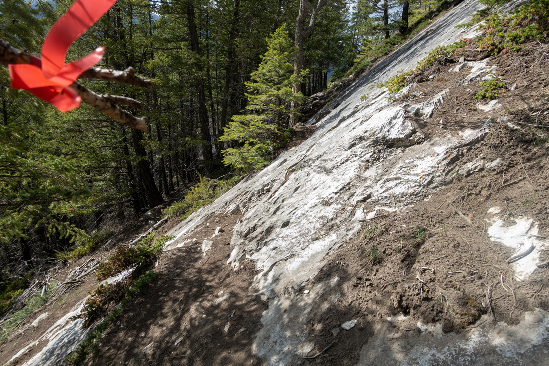 Slab Crossing
Crossing peeling rock slab, conditions should be dry. Note flag. If you find this tricky, drop down in the forest a bit then re-ascend Slab Crossing
Crossing peeling rock slab, conditions should be dry. Note flag. If you find this tricky, drop down in the forest a bit then re-ascend |
|||
 Lower summit panorama
Looking SE as Engagement trail rises above treeline ~45min from Quaite creek. Heart horseshoe center right, Yates Mountain (Barrier Lookout) behind to the left Lower summit panorama
Looking SE as Engagement trail rises above treeline ~45min from Quaite creek. Heart horseshoe center right, Yates Mountain (Barrier Lookout) behind to the left |
|||
|
|
|||
 McConnell Point
Old Tool Shed just below McConnell Point McConnell Point
Old Tool Shed just below McConnell Point |
|||
 Tool Shed Interior
Interior of Old Tool Shed - looks exactly the same in May '23 as it did on my first visit way back in 2014 Tool Shed Interior
Interior of Old Tool Shed - looks exactly the same in May '23 as it did on my first visit way back in 2014 |
|||
 Engagement Viewpoint
McConnell Ridge Panorama looking east towards Hwy 40 corridor with distant Mt. Baldy and Midnight/Midday Peaks Engagement Viewpoint
McConnell Ridge Panorama looking east towards Hwy 40 corridor with distant Mt. Baldy and Midnight/Midday Peaks |
|||
 Razor Edge
Descending slabby terrain on Razor Edge towards Trans-Canada Highway Razor Edge
Descending slabby terrain on Razor Edge towards Trans-Canada Highway |
|||
 Trans-Canada Highway
Final part of Razor Edge directly above Trans-Canada Highway. Final part is ~10min roadside walk to Quaite pull out Trans-Canada Highway
Final part of Razor Edge directly above Trans-Canada Highway. Final part is ~10min roadside walk to Quaite pull out |

Abstract
| Overall Difficulty | D3 | Steep west side ascent with 1 moderate scramble step. Razor Edge descent requires concentration. Some routefinding | |||
| Snow Factor | S2 | Typical front-ranges conditions, generally feasible year-round. Possibility of deep snow on McConnell Point Ridge. Crossing exposed slabs on west side can be difficult in icy conditions | |||
| Scenery | Front Ranges. Nice view of peaks on north side of Bow Valley. Heart Mountain Horseshoe to the south | ||||
| Trail/Marking | Good/None | Sections of trail well defined, but mostly a route with occasional cairns and flags | |||
| Suggested Time | 4 hrs | For loop presented on this page. Less for simple return via Quaite Creek valley instead of suggested Razor edge descent | |||
| Elevation |
Start: 1300m Max: 1760m Total: ~600m |
Round Trip: ~7km (Razor Edge loop return) | |||
| Gear | Full or day hikers with good sole grip. Poles helpful. Micro-spikes can prove useful for winter trips | ||||
| Water | Seasonal water in Quaite creek valley, dries out later in season. Carry 1L | ||||
| Dog Friendly | Yes | Standard backcountry travel precautions | |||
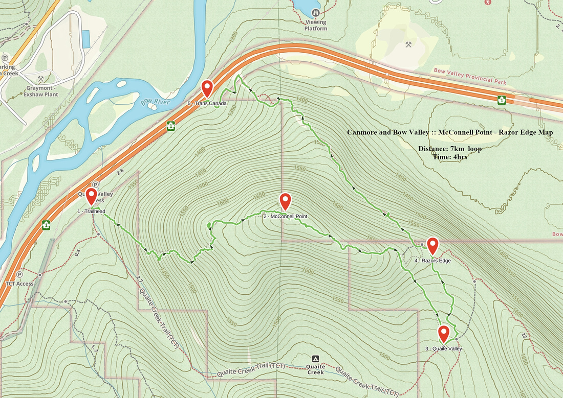 McConnell Point - Razor Edge GAIA Map
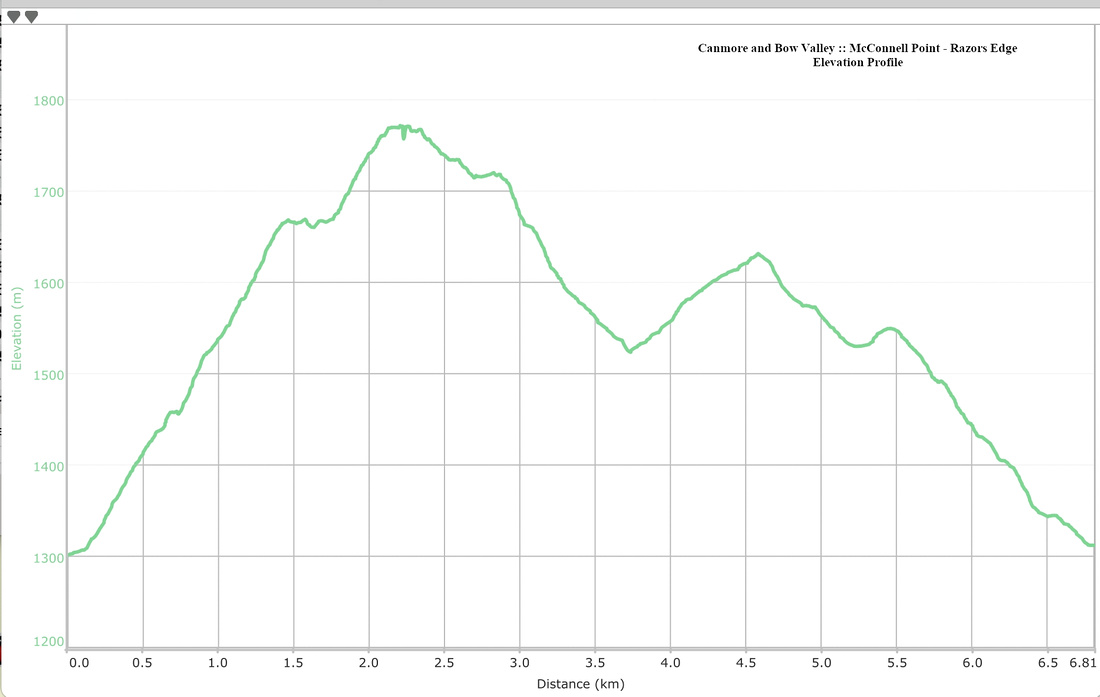 McConnell Point - Razor Edge Elevation Profile