Google Map |
Rockies :: Kananaskis :: Nameless (Eagle) Ridge |
GPS Track |
 
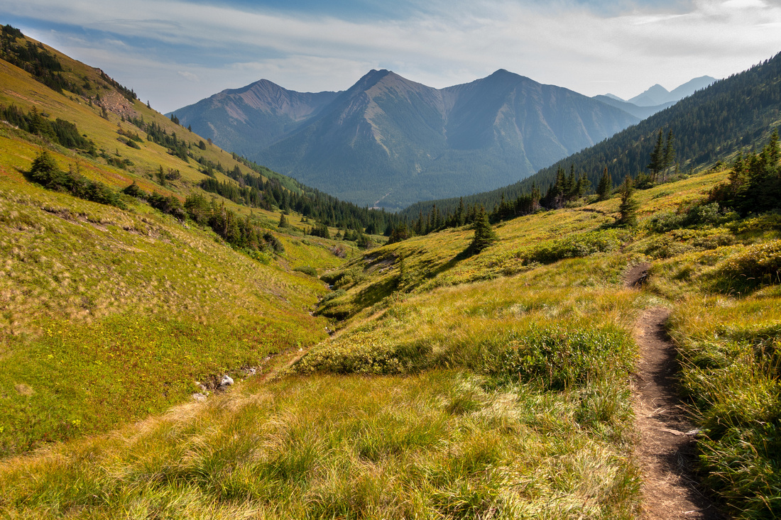
Crest of Nameless Ridge above the Col looking towards hazy South Highwood; Odlum Ridge background center |
|||
| Trip Summary | |||
August 25, 2023South Highwood is terrific area for Ridgewalks and Nameless Ridge, also called "Eagle Ridge" on some Maps, might be the nicest. Trip that naturally leads itself to a loop is short with great effort :: reward ratio. South End access, as described in Kananaskis Trail Guide is unnecessarily roundabout; presented here is alternative that avoids asphalt walk back to trailhead. Note that Hwy40 is seasonally closed Jan 1 - Jun 15 between Kananaskis Lakes and Highwood Junction.
Clockwise loop direction is far preferred for both scenery and practical reasons. Mist Trailhead might be difficult to find; usual parking is some 50m further south at road widening, about a kilometre south from Mt. Lipsett trailhead. This is popular trail so there will usually be cars there - see Gallery. Trail initially rises fairly steeply then moderates by treeline and climbs on green hillside to Nameless Col; less than an hour from the road. Despite usual crowds make lots of noise as this is prime grizz area; on my trip just about everyone I met warned me about trailside grizzly about the col (which I incidentally never saw). From the col Mist trail continues west; turn right and ascent North End of Nameless Ridge on grass and some Talus. Rounded highpoint is terrific spot for lunch break, with Mist Ridge directly east looking fantastic. Following ridgewalk is hands-in-your-pockets with terrific all round views; it is such a shame it is so short as you arrive to South End in 30 mins or so.
On my Trip I decided to follow nice looking grassy gully directly below. By staying on skier right side of obvious drainage I avoided the steep parts and descent was downright enjoyable. Finally at treeline, orienting with GPS I trashed with no problems emerging to Hwy40 less than 50 meters from the car. If not comfortable with this kind of navigation, simply follow SE drop as described in Daffern guide to old road that eventually emerges to Hwy40 ~2km from Mist Trailhead, requiring boring road walk back to the car.
|
|
Gallery |
|||
 Mist Trailhead
Inconspicuous Mist Trailhead with only indication faded pink ribbon is easily missed. Use GPS Track, download on top of page Mist Trailhead
Inconspicuous Mist Trailhead with only indication faded pink ribbon is easily missed. Use GPS Track, download on top of page |
|||
 Mist Trailhead
Looking SE down Hwy40 from Mist Trailhead; note parked cars at road widening left Mist Trailhead
Looking SE down Hwy40 from Mist Trailhead; note parked cars at road widening left |
|||
 Green Hillside
Nameless Ridge west side as Mist Trail emerges above Treeline ~35min from Trailhead. This spot could also be alternate ascent or descent route Green Hillside
Nameless Ridge west side as Mist Trail emerges above Treeline ~35min from Trailhead. This spot could also be alternate ascent or descent route |
|||
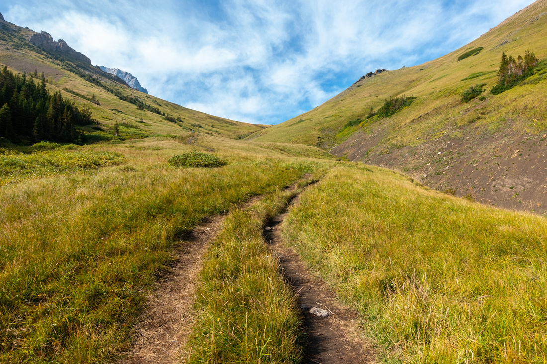 Mist Trail
Great Hiking above Treeline as trail effortlessly gains elevation towards Nameless Col Mist Trail
Great Hiking above Treeline as trail effortlessly gains elevation towards Nameless Col |
|||
|
|
|||
 Nameless Col
, looking north, ~2.5km with 350m vertical from trailhead - takes less than an hour Nameless Col
Nameless Col, looking north, ~2.5km with 350m vertical from trailhead - takes less than an hour |
|||
 Mist Mountain
 from Nameless Col; ascent is just steep talus hiking. Takes ~2.5hr from the col Mist Mountain
Mist Mountain from Nameless Col; ascent is just steep talus hiking. Takes ~2.5hr from the col |
|||
 Nameless Col
Looking down to Nameless Col from ridge ascent slope. Mist scramble route climbs talus slope center; popular Hotsprings are to the right Nameless Col
Looking down to Nameless Col from ridge ascent slope. Mist scramble route climbs talus slope center; popular Hotsprings are to the right |
|||
 Nameless Marmot
Hoary Marmot at Nameless Ridge North End - what an observation point! Nameless Marmot
Hoary Marmot at Nameless Ridge North End - what an observation point! |
|||
 Mist Ridge
 Panorama from Nameless North End Mist Ridge
Mist Ridge Panorama from Nameless North End |
|||
 Mist Ridgewalk
Delightful Hiking on Nameless Ridge rounded spine - easily one of nicest ridgewalks in Kananaskis Mist Ridgewalk
Delightful Hiking on Nameless Ridge rounded spine - easily one of nicest ridgewalks in Kananaskis |
|||
 Nameless Ridgewalk
Looking back north from middle part of Nameless Ridge; Mist Mtn upper center left Nameless Ridgewalk
Looking back north from middle part of Nameless Ridge; Mist Mtn upper center left |
|||
 Descent Gully
South End gully, avoids unnecessary roundabout descent described in Kananaskis Trail Guidebook. Odlum Ridge across Descent Gully
South End gully, avoids unnecessary roundabout descent described in Kananaskis Trail Guidebook. Odlum Ridge across |
|||
 Descent Gully
Looking back up descent gully near Treeline; I stayed on (climber) left side and had zero problems Descent Gully
Looking back up descent gully near Treeline; I stayed on (climber) left side and had zero problems |
Abstract
| Overall Difficulty | D3 | Trail hiking to the col followed with straightforward off-trail ascent on grass/talus and ridge traverse. Steep descent on grass with some micro-terrain route finding. Mild bushwhack below treeline | |||
| Snow Factor | S5 | Not feasible in winter as Hwy40 is annually closed Dec 1 - Jun 15 past K-Lakes turnoff | |||
| Scenery | Exceptional Panoramic views of South Highwood. Alpine Meadows, Mist Mountain and Front Ranges | ||||
| Trail/Marking | Good / None | Well defined trail to Nameless Col, route afterwards (no cairns or flags) | |||
| Suggested Time | 4hr | Full loop utilizing descent gully described in this report. Following Daffern route will add an hour | |||
| Elevation | Start: 1850 m Max: 2490 m Total: ~750 m | Round Trip: ~7 km | |||
| Gear | Full Hikers preferred. Poles very helpful for descent. GPS might be helpful for locating trailhead / bushwhack below treeline, but is not essential | ||||
| Water | Seasonal Mist Creek dries out higher up. Carry 1L min, depending on conditions | ||||
| Dog Friendly | Yes | Prime grizzly bear habitat; keep dog on leash, or leave at home | |||
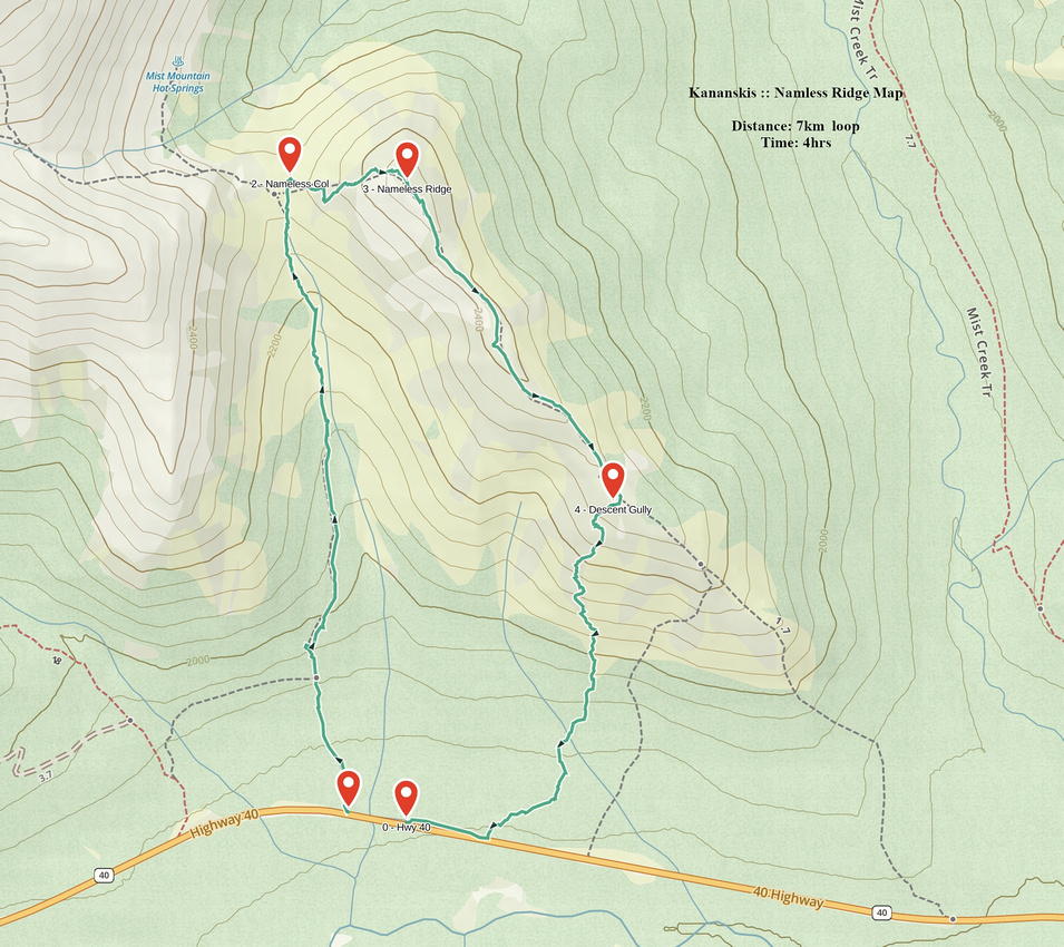 Namless Ridge GAIA Map
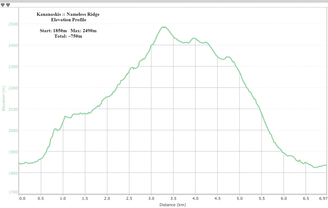 Nameless Ridge Elevation Profile