Google Map |
Rockies :: Alberta Foothills :: Belmore Browne |
GPS Track |
 
Looking back to Belmore Browne (center left) from top of ascent gully below Tiara Ridge. Moose and Prairie Mtn distant background |
|||
| Trip Summary | |||
Oct 7, 2024Belmore Browne is great front ranges objective. There are no real difficulties, but it is still route with some rough sections and easy scrambling. Access is via Powderface Trail Road (seasonally closed Dec 1 - May 15 between Dawson Creek and Hwy 66). Main problem might be finding the Trailhead; it is not marked, and there is no parking area - just pullout on east side of the road ~3km south of Lusk Pass / Jumpingpound Ridge Trailhead. It helps getting familiar via Google Street View as trail can be spotted at west side of the road at N50° 57.316' W114° 57.033', GPS Track Download Top of Page. There is space only for 2 or 3 cars; if someone already there you might have to park at suitable spot further up or down the road
Below the road trail drops somewhat steeply, then after crossing Jumpingpound Creek (2 logs or walk around) follows cutblock for 20-25minutes. Just before cutblock drops down to west branch of Jumpingpound creek draining Tiara Ridge above trail cuts into the trees; this spot is marked by cairn, but on my trip I missed this junction completely and ended trashing up the creek before intersecting the trail higher up. (GPS Waypoint "1-Cutblock"). On return I took the "shortcut" and it had some annoying ups and downs, along some deadfall - pick your poison. Either way it is not a big deal. Higher up are the Forks - take the right (north) branch, cairn marks the way - see Gallery. Going becomes more rough and although snippets of trail shift from one side to the other, it is probably best to simply churn your way up the stony creekbed. Good Talus trail develops just above treeline. Usual direct route up Belmore Browne branches right but ascent slopes are quite steep and lose. In my opinion it is best to follow drainage all the way to Tiarra Ridge as footing is very stable, almost like a staircase. It will take solid 2 hours to reach the saddle where fantastic views unfolds; this is great spot for a break. Boundary Peak is directly north along with entire Boundary Ridge that links Midnight / Midday peaks with Tiara, while Porcupine ridge - optional long day exit to Hwy40 can also be surveyed. From the top of rise above the saddle, talus trail traverses east ridge to rocky summit of Belmore Browne. Final few minutes are easy scrambling with trail bypass on right side. Obvious choice for descent is direct route down steep slopes but I advise against - it is lose with ball-bearing scree you can't surf, but poses stability issues despite rivers of scree trails made by others. It is best to return the same way; even if longer in terms of distance, there might be no time saving due to nature of terrain.
Through hike connecting Belmore Browne and Boundary Ridge, ending at Lusk Pass Trailhead is highly recommended. If without 2 cars bringing bicycle is overkill in my opinion as distance between trailheads is only 3km and can easily be fast walked in 30-40min, depending on pace. On my trip in the fall of '24 from Tiara Ridge I hiked first to Boundary Peak before returning the same way and scrambling Belmore Browne. This is the good extension even if not planning full Boundary Traverse. |
|
Gallery |
|||
 Powderface Trailhead
Powderface Road Pullout with Belmore Browne, just right of center. Trail drops into Jumpingpound Creek Valley at other side of the Road Powderface Trailhead
Powderface Road Pullout with Belmore Browne, just right of center. Trail drops into Jumpingpound Creek Valley at other side of the Road |
|||
 Cutblock Trail
Hiking along wide Cutblock for 20-25min with view of Tiara Peak (L) and Belmore Browne (R) Cutblock Trail
Hiking along wide Cutblock for 20-25min with view of Tiara Peak (L) and Belmore Browne (R) |
|||
 Jumpingpound Ridge
View back to long Jumpingpound Ridge (scenic ridgewalk south of Cox Hill) Jumpingpound Ridge
View back to long Jumpingpound Ridge (scenic ridgewalk south of Cox Hill) |
|||
 Forks Cairn
Cairn at the Forks (view back) Forks Cairn
Cairn at the Forks (view back) |
|||
 Tiara Drainage
Good trail develops above Treeline after 15-20min trash in stony creekbed. Direct Belmore Route forks climber right around here, but it is steep and lose - much better to continue up the drainage to Tiara Ridge Tiara Drainage
Good trail develops above Treeline after 15-20min trash in stony creekbed. Direct Belmore Route forks climber right around here, but it is steep and lose - much better to continue up the drainage to Tiara Ridge |
|||
 Tiara Drainage
Looking back to one of Bryant ridge peaks. Steep and lose direct Belmore route left Tiara Drainage
Looking back to one of Bryant ridge peaks. Steep and lose direct Belmore route left |
|||
 Talus Tree
Lone Pine Tree as wide drainage gently curls left. Hiking is very pleasant here Talus Tree
Lone Pine Tree as wide drainage gently curls left. Hiking is very pleasant here |
|||
 Belmore Skyline
View back to pointy knob of Belmore Browne higher up. Easiest ascent line stays in the drainage all the time, roughly light/shadow demarcation lower right. Moose and Prairie Mtn background Belmore Skyline
View back to pointy knob of Belmore Browne higher up. Easiest ascent line stays in the drainage all the time, roughly light/shadow demarcation lower right. Moose and Prairie Mtn background |
|||
 Tiara Saddle
Just below Tiara Ridge low point. From the saddle Tiara route goes left; turn right for Belmore Browne Tiara Saddle
Just below Tiara Ridge low point. From the saddle Tiara route goes left; turn right for Belmore Browne |
|||
 Boundary Panorama
Boundary Ridge Panorama from Tiara Saddle; highest point also unofficially called "Boundary Peak" center right Boundary Panorama
Boundary Ridge Panorama from Tiara Saddle; highest point also unofficially called "Boundary Peak" center right |
|||
 Boundary Peak
 from knob above Tiara Saddle is ~40min away and despite what photo might suggest entirely hands in your pockets Boundary Peak
Boundary Peak from knob above Tiara Saddle is ~40min away and despite what photo might suggest entirely hands in your pockets |
|||
 Belmore Browne
Hiking Belmore Browne Ridge; scree trail exits most of the way. Steep direct route follows left-right talus slope back to Tiara Drainage Belmore Browne
Hiking Belmore Browne Ridge; scree trail exits most of the way. Steep direct route follows left-right talus slope back to Tiara Drainage |
|||
 Summit Block
Rocky Belmore Browne Summit Block - just few steps of easy scrambling. Trail snippets lead on right side Summit Block
Rocky Belmore Browne Summit Block - just few steps of easy scrambling. Trail snippets lead on right side |
|||
 Belmore Browne
 Summit cairn with ever-present Pink Register. Boundary Peak behind left Belmore Browne
Belmore Browne Summit cairn with ever-present Pink Register. Boundary Peak behind left |
Abstract
| Overall Difficulty | D4 | Rocky Creek bed and moderately steep Talus. Short couple of easy class 2 scramble steps below the summit. | |||
| Snow Factor | S3 | Moderate avalanche danger in Gully below Tiara Ridge and steep Belmore direct ascent slope. Powderface Trail Road seasonally closed Dec 1 - May 15 | |||
| Scenery | Sweeping scenery of front ranges and foothills Very scenic Boundary and Tiara Ridges | ||||
| Trail/Marking | Poor | Trailhead problematic. Mostly a Route with sporadic cairns and flags. | |||
| Suggested Time | 5 hrs | Return time for Belmore Browne only. Add at least an hour for Boundary Peak, more for Tiara Peak | |||
| Elevation | Start: 1760m Max: 2370m Total: ~750m (Belmore Browne OnB) | Round Trip: ~11km (Belmore Browne OnB) | |||
| Gear | Full hiking boots, poles and gaiters. GPS essential. Wind-breaker as ridge is wind-blown year round. Climbing helmet in groups | ||||
| Water | Jumpingpound Creek drainage, dries off higher up. Seasonal snow patches. Carry 1L+ depending on season | ||||
| Dog Friendly | Yes | Standard back-country travel precautions | |||
 Belmore Browne GAIA Map
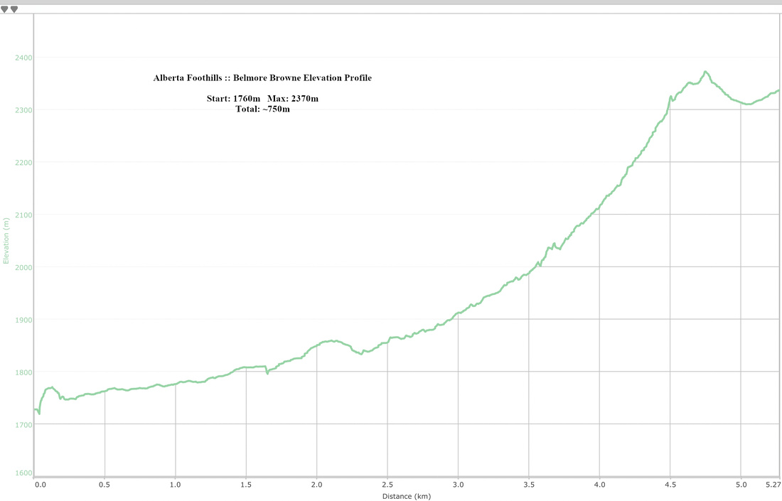 Belmore Browne Elevation Profile