Google Map |
USA :: Sedona :: Fay Canyon |
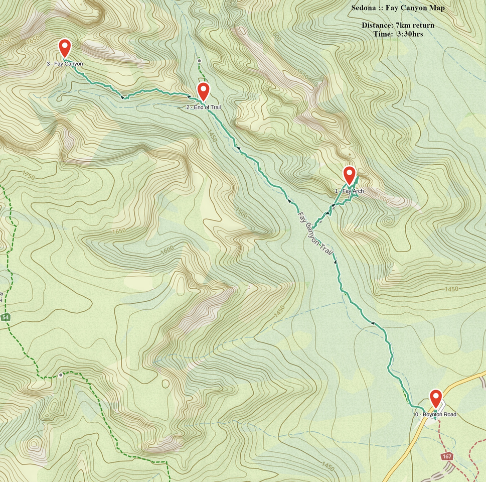
GPS Track |
 
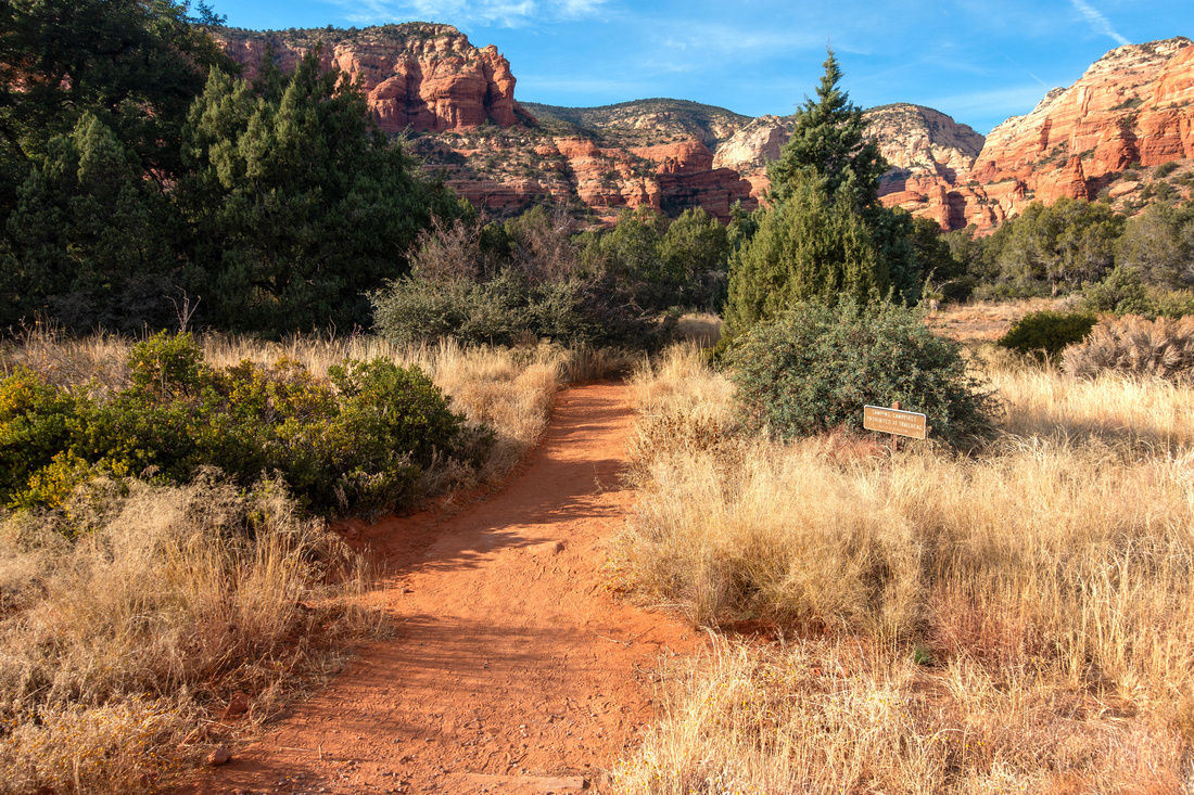
Fay Canyon Arch, largest Sedona Arch, lit by afternoon sunshine - a must side trip |
|||
| Trip Summary | |||
Dec 13 2017, Nov 27 2023
Short excursion into deep Canyon with much options for further exploration. Trailhead parking is at east side of Boynton Pass Road, 15-20min from downtown Sedona. Official trail ends below imposing Supai sandstone cliff splitting canyon into East/West branches where most hikers turn back. Exploring both branches is possible, but considerably more difficult requiring proper footwear and clothing. Both of my Trips I ventured into left (west) branch by scrambling ledges on faint, progressively more difficult - but still distinct - trail to base of steep cliffs at canyon end (Waypoint "3 - Fay Canyon", GPS Track download Top of Page). It is apparently possible to climb over to plateau below Bear Mountain from here; if you try this you are on your own and really must know what you are doing. East branch apparently leads to old Sinagua Ruins, but they are well hidden and finding them is neither straightforward or easy.
Halfway up the Canyon side trail on right (north) side heads to quite famous Fay Canyon Arch, lead photo on this page. This junction is not marked but obvious; if in doubt refer to GPS Track. Steep Trail is somewhat eroded; hiking poles are an asset here. This short extension is main scenic Highlight and a must. Some hikers scramble to top of the Arch but this is dangerous and not recommended. From lighting / photography perspective mid-Afternoon is optimal time as trademark Red Rock will be on fire while rest of The Canyon is slowly falling in shade. |
|
Gallery |
|||
 |
|||
 Fay Trail
After crossing the Road wide Track heads into the mouth of Fay Canyon Fay Trail
After crossing the Road wide Track heads into the mouth of Fay Canyon |
|||
|
|
|||
 Fay Arch
Arch viewpoint near the entrance Fay Arch
Arch viewpoint near the entrance |
|||
|
Impressive Supai Cliff at Fay Trail End. Scramble broken rock then continue on faint trail hugging left side of the cliff |
|||
|
|
|||
 West Branch Ledge
View back while scrambling Red Rock ledges leading deep into West Fay Branch West Branch Ledge
View back while scrambling Red Rock ledges leading deep into West Fay Branch |
|||
 Fay Red Rock
Classic Sedona Red Rock Grotto deep into West Fay Branch Fay Red Rock
Classic Sedona Red Rock Grotto deep into West Fay Branch |
|||
 Egyptian Wall
Sandstone Rock Erosion resembling Queen Hatshepshut Temple Wall Murals in Luxor Valley of the Kings Egyptian Wall
Sandstone Rock Erosion resembling Queen Hatshepshut Temple Wall Murals in Luxor Valley of the Kings |
|||
 Red and Green
Exploring West branch requires proper clothing as there is lots of prickly stuff to clamber through Red and Green
Exploring West branch requires proper clothing as there is lots of prickly stuff to clamber through |
|||
 West Branch End
Ledge Trail ending at West Branch End. Scrambling Bear Mountain Plateau is apparently possible West Branch End
Ledge Trail ending at West Branch End. Scrambling Bear Mountain Plateau is apparently possible |
|||
 West Branch Ledge
Looking back at turnaround point as Ledge Trail disintegrated into thickets of dense bush West Branch Ledge
Looking back at turnaround point as Ledge Trail disintegrated into thickets of dense bush |


Abstract
| Overall Difficulty | D3 | Steep eroded trail to Fay Canyon Arch. Class 2 scrambling past trail end to upper Canyon / Sinagua Ruins | |||
| Scenery | Fay Canyon Arch, Classic Sedona Red Rock Formations. Beautiful inner canyon past trail end | ||||
| Trail/Marking | Very Good | Official Sedona Trail with Trailhead Map. Fay Canyon junction not marked. Exploratory off-trail upper canyon | |||
| Suggested Time | 3-4 hrs | Including Fay Canyon Arch and exploration past official Trail End | |||
| Elevation | Start: 1400m Max: 1540m Total: +450m | Round Trip: 7km | |||
| Gear | Light hikers are sufficient | ||||
| Water | No reliable source. Carry 0.5-1L or more, depending on season | ||||
| Dog Friendly | Yes | Popular trail - dogs must be kept on leash. Standard desert travel precautions. | |||
 Fay Canyon GAIA Map
 Fay Canyon Elevation Profile