Google Map |
Rockies :: Kananaskis ::Buller Pass Loop / Red Peak |
GPS Track |
 
Panoramic view south from 2780m Red Peak summit. North Buller Pass low saddle dead center |
|||
| Trip Summary | |||
July 27, 2023Logical extension of popular South Buller Pass and one of most scenic trips in K-country providing excellent reward for the effort. Reasonable level of fitness is required as there is over 1500m cummulative elevation. It is best to wait for second part of summer till snow completely melts; try to pick clear and windless day. Red Peak can be ascended more directly via North Buller Pass, but I strongly recommend heading to South Buller first as the hike behind the passes is super scenic and only marginally longer. This page is presented in such way; see South Buller Pass report for first part.
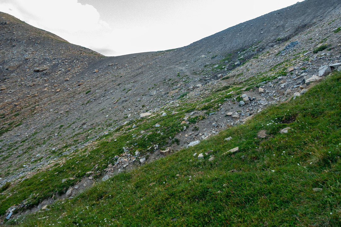
From South Buller Pass trail descends steeply down talus field that should be dry. Do not angle towards meadows (1st pic in Gallery) too soon as it leads to unnecessary side-sloping. Easiest way is marked junction some 15min below the pass (cairn). Faint trail soon disappears but it is not necessary. Delightful hiking on grass over small rise leads to lovely alpine valley east of North Buller; Red Peak is now visible and is as easy as it appears. If short on time aim straight for North Buller, otherwise ascent moderately steep but easy grass (frequent bear diggings) till just below summit ridge, then easy scramble to crest. Stubborn cornice often hangs here till mid-summer and is primary reason why it is best to wait till July. Final part is great ridgewalk, bypassing minor crumbly rock buttress on climber right (trail, cairn).
On return I descended the same way until roughly in line with North Buller, then crossed drainage and easily side sloped on grass towards the pass. Talus trail appears near the top. East side of North Buller is the easiest of the four - while west side is the hardest, specially on descent. It is lose and steep; caution is needed and hiking poles are great asset. It is considerably easier to climb than to descend, as usually the case. Look for bit of trail angling skier right towards grassy rib appearing halfway down, then switchback to valley floor. Very enjoyable hiking then leads along the creek for 45min to an hour to North/South junction on main trail. Lovely canyon appears in the lower part with several waterfalls and cascades; excellent spot for last break of the day.
|
|
Gallery |
|||
 South Buller Pass
Starting descent from South Buller Pass. Goal is to reach meadows in center, then follow drainage left and up South Buller Pass
Starting descent from South Buller Pass. Goal is to reach meadows in center, then follow drainage left and up |
|||
 Ribbon Junction
Junction with small cairn ~15min below South Buller. Ribbon Lake trail continues straight, turn left for North Buller / Red Peak Ribbon Junction
Junction with small cairn ~15min below South Buller. Ribbon Lake trail continues straight, turn left for North Buller / Red Peak |
|||
 Sunlit Ridge
Bottom of grassy draw, looking east towards sunlit ridgeline with Mt. Bogart just peeking above. This would be the spot to head up North Buller Pass (directly behind, out of picture) if not going for Red Peak. It would also be possible to trash down drainage center left, then hike up to saddle upper left and descend talus to Sparrowhawk Tarns Sunlit Ridge
Bottom of grassy draw, looking east towards sunlit ridgeline with Mt. Bogart just peeking above. This would be the spot to head up North Buller Pass (directly behind, out of picture) if not going for Red Peak. It would also be possible to trash down drainage center left, then hike up to saddle upper left and descend talus to Sparrowhawk Tarns |
|||
 Grassy Bench
Delightful meadow hiking on Red Peak lower slopes, looking back. North Buller Pass is out of picture to the right. Grassy nub center left would be great side trip if doing only Buller Pass loop. Grassy Bench
Delightful meadow hiking on Red Peak lower slopes, looking back. North Buller Pass is out of picture to the right. Grassy nub center left would be great side trip if doing only Buller Pass loop. |
|||
 Ribbon Basin
Looking back from Red Peak gently angled ascent slope. Delightful valley with several tarns just left of center doesn't see many visitors and would be great to explore; Ribbon Lake distant behind Ribbon Basin
Looking back from Red Peak gently angled ascent slope. Delightful valley with several tarns just left of center doesn't see many visitors and would be great to explore; Ribbon Lake distant behind |
|||
 Red Peak
Still on moderately angled grass with Red Peak upper center. Goal is to intercept ridge upper left Red Peak
Still on moderately angled grass with Red Peak upper center. Goal is to intercept ridge upper left |
|||
 Red Ridge
Cairn at broad Red Peak ridge. Easy ~15min walk leads to the summit Red Ridge
Cairn at broad Red Peak ridge. Easy ~15min walk leads to the summit |
|||
 Red Cornice
Looking back at snow cornice that can thwart summit bid early in season; just fast melting snow patch on this occasion. North Buller Pass center left Red Cornice
Looking back at snow cornice that can thwart summit bid early in season; just fast melting snow patch on this occasion. North Buller Pass center left |
|||
 Rock Nub
Looking back at eroded rock nub on Red Ridge; bypass trail is on left side (climber right) Rock Nub
Looking back at eroded rock nub on Red Ridge; bypass trail is on left side (climber right) |
|||
 Red Peak Summit
Cairn with Pink Register at Red Peak Summit. Spray Lakes just left of center, Read's Tower and Mt. Sparrowhawk ascent route center right Red Peak Summit
Cairn with Pink Register at Red Peak Summit. Spray Lakes just left of center, Read's Tower and Mt. Sparrowhawk ascent route center right |
|||
 Sparrowhawk Tarns
Aerial view of Sparrowhawk Tarns from Red Peak Summit Sparrowhawk Tarns
Aerial view of Sparrowhawk Tarns from Red Peak Summit |
|||
 North Buller Pass
Easy ascent of North Buller Pass on return from Red Peak; note trail North Buller Pass
Easy ascent of North Buller Pass on return from Red Peak; note trail |
|||
 North Buller Valley
Terrific Valley on west side of North Buller. Good trail exists all the way. Washed out Mt. Buller upper right North Buller Valley
Terrific Valley on west side of North Buller. Good trail exists all the way. Washed out Mt. Buller upper right |
|||
 North Buller Pass
Descending North Buller Pass on lose talus slope, considerably steeper than this photo suggests. Hiking poles are great asset here North Buller Pass
Descending North Buller Pass on lose talus slope, considerably steeper than this photo suggests. Hiking poles are great asset here |
|||
 North Buller
Looking back at steep and fairly challenging west side of North Buller. If climbing this way angle right from top of grassy rib towards low point North Buller
Looking back at steep and fairly challenging west side of North Buller. If climbing this way angle right from top of grassy rib towards low point |
Abstract
| Overall Difficulty | D5 | Off trail hiking with talus slopes and easy scrambling. West side of North Buller is very steep. | |||
| Snow Factor | S4 | North Buller west side considerable avi danger. Persistent cornice on Red Ridge. Loop not really feasible in winter/spring conditions; wait till snow has melted | |||
| Scenery | Spray Corridor and distant BNP Peaks. Delightful alpine valley east of Buller Passes. Small waterfalls and Cascades on west side | ||||
| Trail/Marking | Good / None | Official Alberta Parks Trail to North/South junction, well defined on west side for both passes. Cairned route on east side | |||
| Suggested Time | 8 hrs | Full South - North loop with Red Peak ascent. Subtract at least an hour if doing just the passes, or if climbing Red Peak via North Buller Pass only without loop | |||
| Elevation | Start: 1795m Max: 2780m Total: ~1550m | Round Trip: 20km (Loop + Red Peak) | |||
| Gear | Full Hiking Boots and Poles. Gaiters might be useful for snow field crossings in early season | ||||
| Water | Buller Creek and various seasonal creeks in alpine bowl below the passes. East side generally dry later in summer. Carry 1L | ||||
| Dog Friendly | Yes | Standard Back-country precautions; Buller Creek Trail tends to get busy on weekends & dogs should be kept on leash | |||
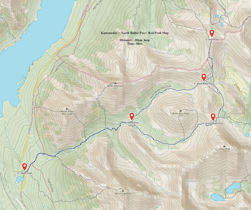 North Buller Pass / Red Peak GAIA Map
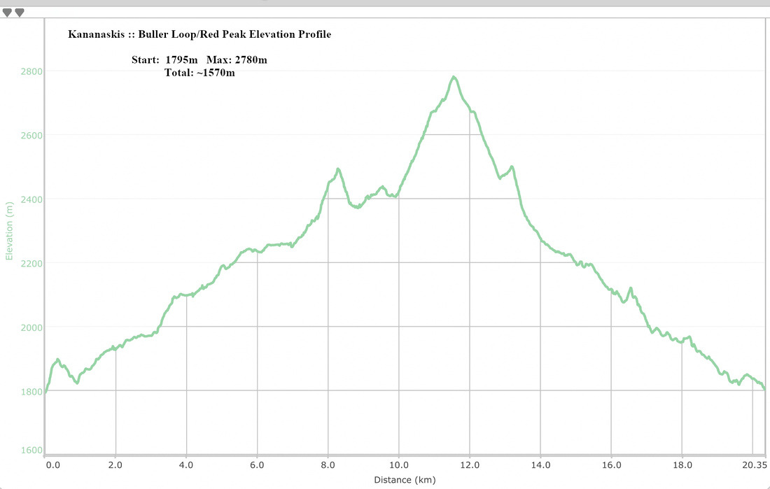 Buller Pass Loop - Red Peak Elevation Profile