Google Map |
Rockies :: Kananaskis :: Birdwood Traverse |
GPS Track |
|
Secluded Alpine valley between Smuts and Birdwood Passes in full Autumn larch splendour |
|||
| Trip Summary | |||
Multiple Dates, last Sep 30, 2024One of best through hikes in K-Country linking several high alpine passes behind Mt. Birdwood. Best done in late September because of abundance of golden larches. Recommended direction is Smuts Pass first, Burstall Pass return. Trailheads are ~5km apart and shuttle logistics require 2 cars or bicycle. Regardless, always hike towards the car - that means parking at Bustall Pass Trailhead then transferring to Mt. Shark/Engadine Trailhead where hike begins. There are no real difficulties, but trip requires being comfortable navigating vast landscapes sans-trail and micro-terrain route finding. There is one brief scramble step below Snow Peak, but very easy. Both Smuts and Burstall Pass Trails are frequently hiked and well documented (see Smutwood Peak and Snow Peak pages for more details). Focus of this report is off-trail traverse between the two, and this is how Gallery is organized.
Smuts Pass approach will take ~ 2.5 hrs, depending on conditions. Sections of trail in Commonwealth Creek valley can be very muddy with plenty of roots that slow down the pace. After climbing steep Smuts Headwall (~350m elev. gain) hike becomes extremely scenic. Hike talus around BIrdwood lakes between east and west Smuts Pass, then leave trail at shoulder where normal Smutwood Scramble starts; this is the start of Birdwood Traverse (Waypoint "4 - Smutwood Junction", GPS Download Top of Page). Objective is to traverse alpine valley on SW side of Birdwood Peak towards distant Birdwood Pass below Snow Peak (see Gallery). Without losing elevation find faint trail developing in wooded area; it becomes better defined the further you go. After reaching valley bottom trail disappears by the cairn. Ascend grassy slopes dotted with larches and small bubbling creeks towards Birdwood Pass; this part is pure joy to hike. From Birdwood Pass continue down Talus Bench till you are about to get cliffed out on left (east) side, then easy scramble up broken ground to upper shelf below Snow Peak and descend south eventually intercepting Bustall Pass Trail by Banff National Park boundary; ~2.5hrs from Smuts Pass. Hike out back to Spray Road on wide and well travelled Burstall Pass Trail. In late September sometimes cumbersome crossing of Flats below Commonwealth Peak has dried out and will not present problems.
This is highly recommended trip for seasoned outdoor explorers. I've done it several times and am likely to repeat again. If you can hit it right in terms of conditions as Gallery showcases, simply outstanding. |

|
Gallery |
|||
 Smuts Pass Ascent Smuts Pass Ascent Wide trail ascending Smuts Pass above Commonwealth Creek Valley. Smuts Peak upper right
 |
|||
|
|
|||
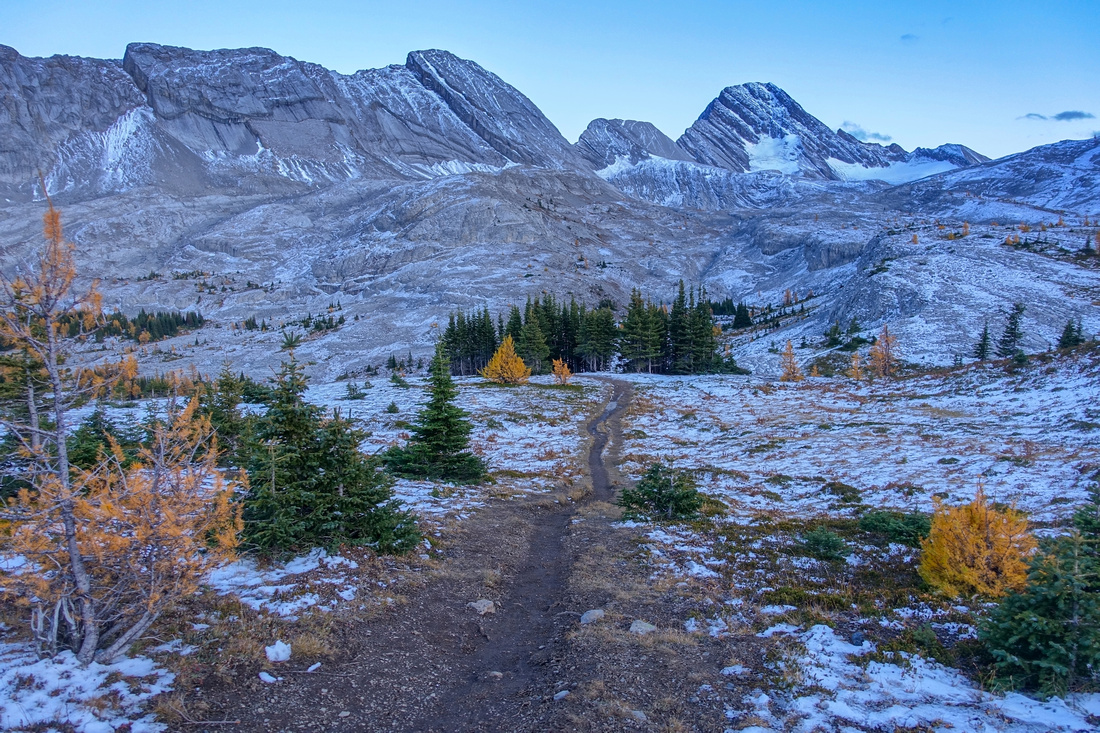
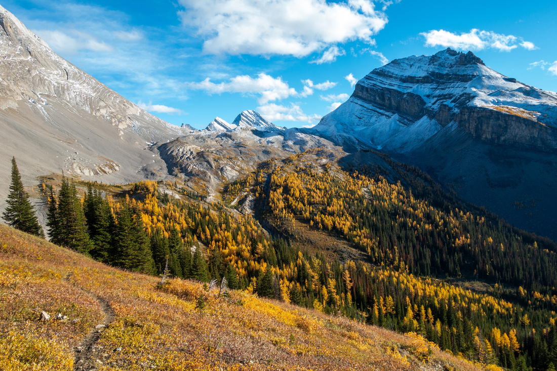 BIrdwood Valley
Faint trail descending forest / grass below west Smuts Pass. Birdwood Pass notch below Snow Peak just right of center BIrdwood Valley
Faint trail descending forest / grass below west Smuts Pass. Birdwood Pass notch below Snow Peak just right of center |
|||
 Birdwood Valley
Valley full of Autumn Gold Colours. Faint trail disappears after crossing Pine tree stand center left Birdwood Valley
Valley full of Autumn Gold Colours. Faint trail disappears after crossing Pine tree stand center left |
|||
 Alpine Hiking
Spectacular Alpine hiking sans trail towards Birdwood Pass (C) - pick any line. Snow Peak upper right Alpine Hiking
Spectacular Alpine hiking sans trail towards Birdwood Pass (C) - pick any line. Snow Peak upper right |
|||
 Larch Goodness
Golden Larches at their prime below Birdwood Pass Larch Goodness
Golden Larches at their prime below Birdwood Pass |
|||
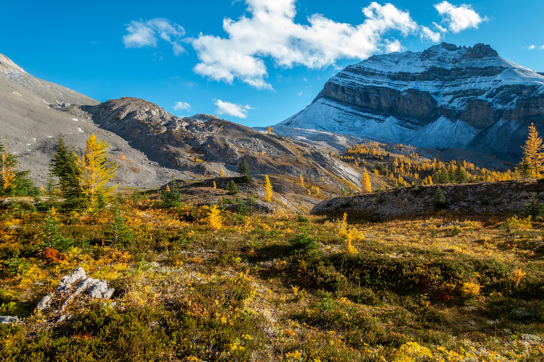
 Birdwood Pass
Windswept Birdwood Pass below Snow Peak with view of Sir Douglas Birdwood Pass
Windswept Birdwood Pass below Snow Peak with view of Sir Douglas |
|||
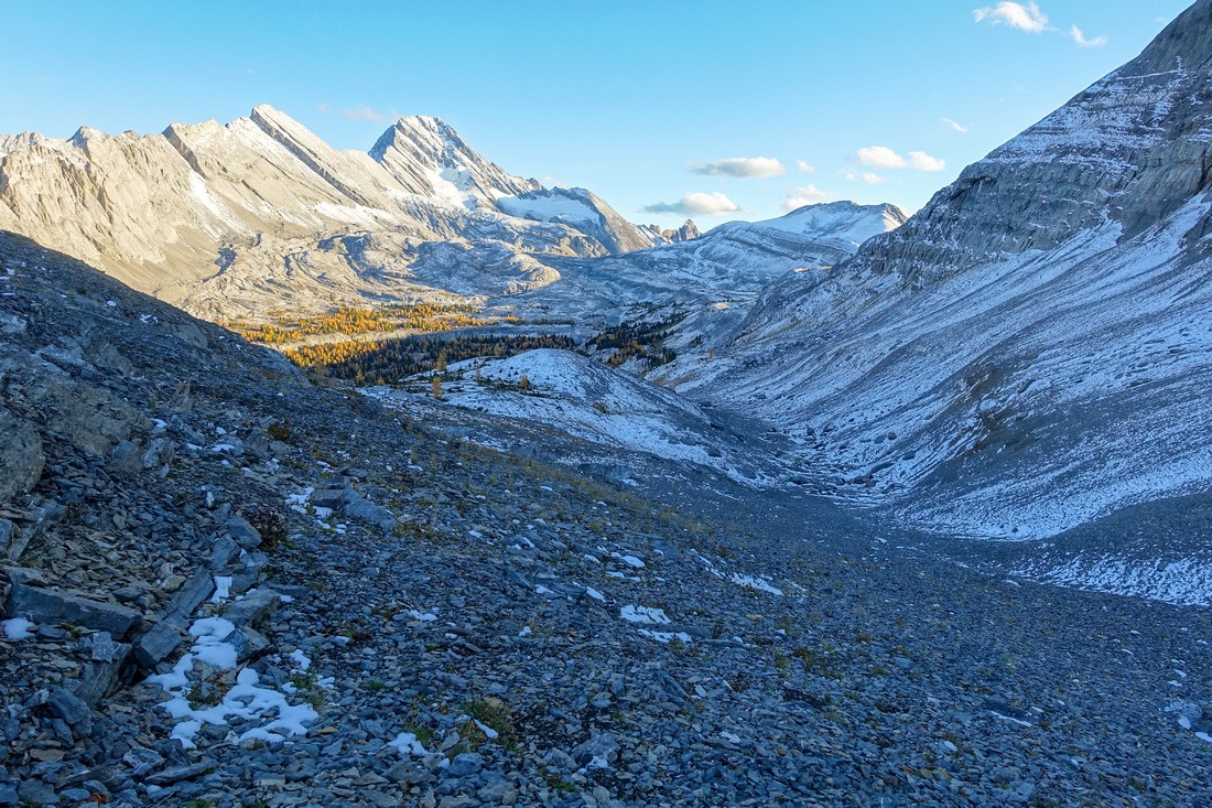 Snow Peak Shelf
Talus descent south of Birdwood Pass. Follow basin till you are about to get cliffed out on left side, then easy scramble to upper ledge and intercept standard Snow Peak scramble route above Burstall Pass Snow Peak Shelf
Talus descent south of Birdwood Pass. Follow basin till you are about to get cliffed out on left side, then easy scramble to upper ledge and intercept standard Snow Peak scramble route above Burstall Pass |
|||
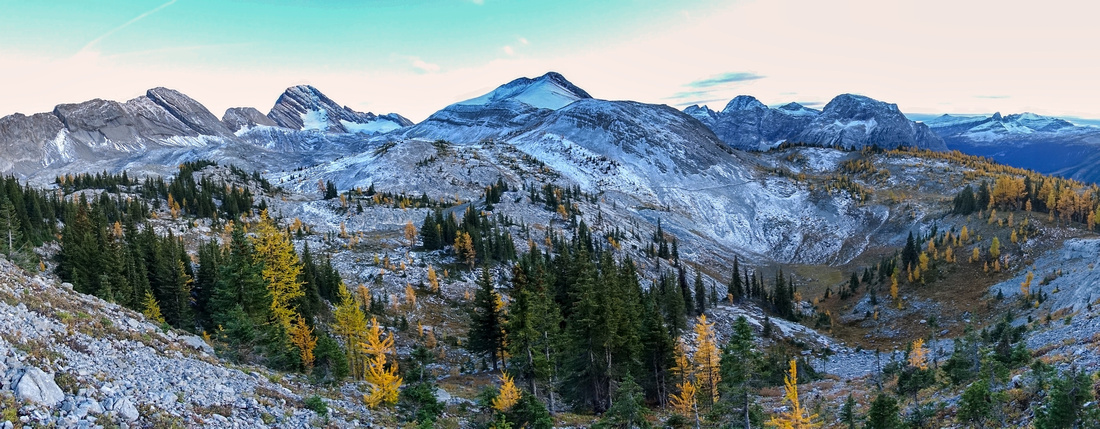 Burstall Pass Panorama
Navigating Glorious Alpine Environs above Burstall Pass with view of Burstall Pass Peak center Burstall Pass Panorama
Navigating Glorious Alpine Environs above Burstall Pass with view of Burstall Pass Peak center |
|||
 Burstall Pass Trail
Starting descent from Burstall Pass with view of Sir Douglas (R) and Whistling Rock (L) Burstall Pass Trail
Starting descent from Burstall Pass with view of Sir Douglas (R) and Whistling Rock (L) |
|||
 Burstall Trail
Hiking out back to Spray Road via standard Burstall Pass Trail. Mt. Birdwood upper left Burstall Trail
Hiking out back to Spray Road via standard Burstall Pass Trail. Mt. Birdwood upper left |

Abstract
| Overall Difficulty | D4 | Steep talus below Smuts Pass. Rough and Muddy trail in Commonwealth Creek Valley. Off-trail traverse below Birdwood Peak with micro-terrain routefinding. Short easy ledge scramble below Snow Peak. | |||
| Snow Factor | S3 | Excellent Alpine Tour in winter. Moderate avalanche danger on steep slopes below Snow Peak / Smuts Pass descent | |||
| Scenery | Alpine Passes, Lakes, Peaks and Larches. Classic K-country at its best | ||||
| Trail/Marking | Very Good / None | Well defined and used Smuts and Burstall Pass trails. Faint trail initially descending from Smuts Pass disappears in Alpine Bowl below Mt. Birdwood. Micro-terrain routefinding between BIrdwood and Smuts Pass | |||
| Suggested Time | 8hrs | Moderate Pace in dry conditions. Add shuttle time between Burstall and Shark trailheads | |||
| Elevation | Start: 1875m End: 1900m Max: 2450 m Total: ~1100m | Distance: 21km loop | |||
| Gear | Full hiking boots and poles. Gaiters for muddy parts of trail and Commonwealth Creek Flats. GPS helpful. | ||||
| Water | Commonwealth and Burstall Creeks. Side streams in upper Birdwood Valley. Carry 1L | ||||
| Dog Friendly | Yes | Back-country travel precautions. Prime grizzly bear habitat. Burstall / Smuts trails very popular - keep dog on leash | |||
 Birdwood Traverse GAIA Map
 Birdwood Traverse Elevation Profile