Google Map |
Rockies :: Kananaskis :: Piggy Plus |
GPS Track |
|
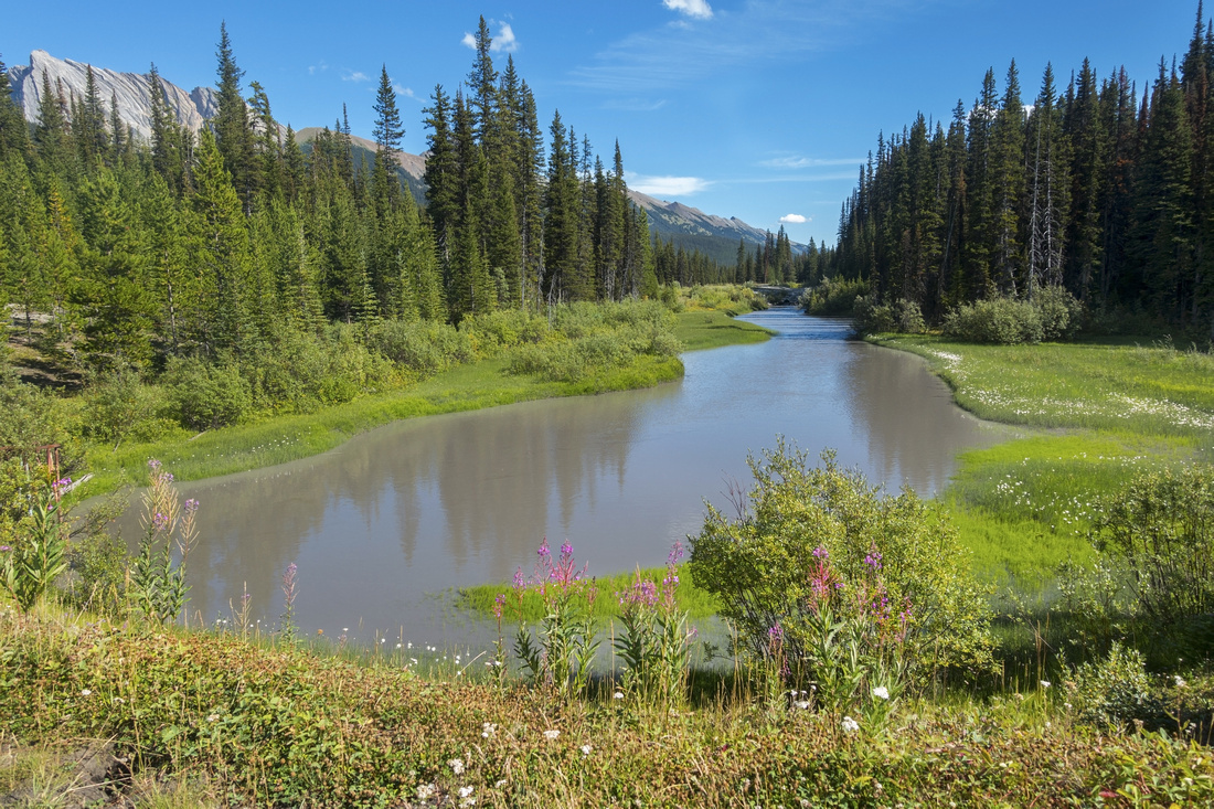
Panoramic view north from Piggy Plus col; length of approach valley center |
|||
| Trip Summary | |||
Multiple Dates, last Sep 19, 2025Delicate pocket valley ending with high col above French Creek. Still very much off radar despite being being mentioned in printed guidebooks and various personal online sites. Second part of September is specially great time for visit due to abundance of golden larches. Outing is fairly short (~5hrs RT) with option for further wondering around.
Access is via popular Burstall Pass Trail on west side of Spray Road where solitude will be hard to find. But after branching off (Waypoint '1 - Burstall Pass Trail', GPS Download Top of Page, ~40min of fast pace from parking) you are almost guaranteed to be on your own - at least on weekdays. Both times I went this way I never met anyone! There are no route-finding problems. Well defined trail disappears in upper valley, but it is not needed anymore. Cairns lead the way up gentle talus field to "Piggy Plus Col". This windswept saddle high above French Creek drainage is fantastic viewpoint. From the col die hard scramblers head up "Piggy Plus" summit on the west side; while short it is difficult and even dangerous - I strongly advise against as there is nothing to gain except social media bragging rights. Better option is to head up east side ridge. You can go as far as you want, but the further you go the more difficult it gets, and it does not connect all the way to main Mt. Burstall summit. I usually turn back at first rise where both French and Robertson Glaciers are visible (Robertson Glacier remains hidden at Piggy Plus col).
Return is the same way, but with outing so short if not in a time crunch I suggest exploring the valley a bit. In particular west side flanked by lower Piggy Ridge. After descending talus below Piggy Plus Col angle skier left across meadows and gorgeous sunken valley, then easily hike up to ridge above Robertson drainage. Someone named it "Piggy Minus" and although not a summit of any sort, name seems to stick. Robertson Glacier looks fantastic below giant Sir Douglas - see Gallery. On return simply cut across the meadow aiming towards the drainage and intercept main Valley trail; you might have to downclimb bit of peeling rock band, but it presents no problems.
Highly recommended outing for Autumn larch season. |

|
Gallery |
|||
 Bear Warning Bear Warning Posted Burstall Pass trailhead bear warnings are common occurence
 |
|||
|
|
|||
 Piggy Junction Piggy Junction
|
|||
| Unsigned Piggy Plus junction just over 3km from Trailhead. Waypoint '1 - Burstall Pass Trail', GPS Download Top of Page | |||
 Overgrown clearing
Looking back towards Mt. Birdwood, Pigs Tail and Commonwealth peak as trail crosses overgrown clearing after steeply climbing for ~15min Overgrown clearing
Looking back towards Mt. Birdwood, Pigs Tail and Commonwealth peak as trail crosses overgrown clearing after steeply climbing for ~15min |
|||
 Creek Crossing
Piggy Drainage crossing higher up marked by cairns; pay attention on descent Creek Crossing
Piggy Drainage crossing higher up marked by cairns; pay attention on descent |
|||
 Talus canyon
More rough section as trail ascends short canyon below Piggy bowl Talus canyon
More rough section as trail ascends short canyon below Piggy bowl |
|||
 Piggy Bowl
Entering lower Piggy Bowl, and last chance to fill water late in season. Trail soon leaves creek bed and climbs on right side Piggy Bowl
Entering lower Piggy Bowl, and last chance to fill water late in season. Trail soon leaves creek bed and climbs on right side |
|||
 Fall Colours
Spectacular Fall Colours in 2nd half of September Fall Colours
Spectacular Fall Colours in 2nd half of September |
|||
 Lone Larch
Spectacular Fall Colours in 2nd half of September Lone Larch
Spectacular Fall Colours in 2nd half of September |
|||
 Upper Bowl
Grassy bench below rocky outcrops with Piggy Plus col upper center. Cairns lead the way up Talus slope ahead Upper Bowl
Grassy bench below rocky outcrops with Piggy Plus col upper center. Cairns lead the way up Talus slope ahead |
|||
 Above the Col
Looking down at Piggy Plus col from lower Burstall Ridge Above the Col
Looking down at Piggy Plus col from lower Burstall Ridge |
|||
 Burstall Ridge
Length of Burstall ridge with approach valley center. It is possible to keep going for quite awhile, but conditions become progressively more difficult and it does not connect all the way to Mt. Burstall summit. Burstall Ridge
Length of Burstall ridge with approach valley center. It is possible to keep going for quite awhile, but conditions become progressively more difficult and it does not connect all the way to Mt. Burstall summit. |
|||
 Upper French Panorama
Upper French creek from lower Burstall ridge, L-R: Mt. Murray, Prairie View and Mt. Roberston. Both French and Robertson Glaciers are visible center right. Piggy Plus summit upper right foreground Upper French Panorama
Upper French creek from lower Burstall ridge, L-R: Mt. Murray, Prairie View and Mt. Roberston. Both French and Robertson Glaciers are visible center right. Piggy Plus summit upper right foreground |
|||
 Prairie Lookout
Innocently named "Prairie Lookout" peak (3185m) rising above upper French creek. Listed as difficult scramble; stay away for your own sake Prairie Lookout
Innocently named "Prairie Lookout" peak (3185m) rising above upper French creek. Listed as difficult scramble; stay away for your own sake |
|||
 |
|||
 Sunken Meadows
Looking back across larch dotted sunken valley on return with Piggy Plus col upper right Sunken Meadows
Looking back across larch dotted sunken valley on return with Piggy Plus col upper right |
|||
 Piggy Minus
South Panorama from lower part of Piggy Ridge, sometimes called "Piggy Minus". It is possible to continue for awhile, but it does not connect all the way. Robertson Glacier distant center right Piggy Minus
South Panorama from lower part of Piggy Ridge, sometimes called "Piggy Minus". It is possible to continue for awhile, but it does not connect all the way. Robertson Glacier distant center right |
|||
 |
|||
 Piggy Minus
Gorgeous Autumn panorama looking north from "Piggy Minus". Lots of further delightful exploration is possible. Burstall Pass trail runs in the valley center left. L-R: Snow Peak, Mt. Birdwood, Pigs Tail and Commonwealth Peak Piggy Minus
Gorgeous Autumn panorama looking north from "Piggy Minus". Lots of further delightful exploration is possible. Burstall Pass trail runs in the valley center left. L-R: Snow Peak, Mt. Birdwood, Pigs Tail and Commonwealth Peak |
Abstract
| Overall Difficulty | D3 | Gentle trail hiking most of the way. Moderately steep talus slope below Piggy col. | |||
| Snow Factor | S3 | Upper bowl below the col narrow and could be dangerous in unstable snow conditions | |||
| Scenery | Spectacular valley with sunken meadows and abundant larches. French and Roberston glaciers. Many Spray corridor peaks | ||||
| Trail/Marking | Very Good | Official Burstall Pass trail followed by narrow but well defined path into Piggy bowl. Junction not marked | |||
| Suggested Time | 5hrs | Return time including side trip to north end of Piggy Ridge | |||
| Elevation | Start: 1900m Max: 2530 m Total: ~670m | Distance: 15km return | |||
| Gear | Full hiking boots or dayhikers; poles helpful | ||||
| Water | Creek draining lower Piggy bowl usually has water late in season, dries out higher up. Carry ~1L | ||||
| Dog Friendly | Yes | Standard back-country travel precautions. Prime grizzly bear habitat, and incidents have occurred in the past | |||
 Piggy Plus GAIA Map
 Piggy Plus Elevation Profile