Google Map |
USA :: Sedona :: Boynton Canyon |
GPS Track |
 
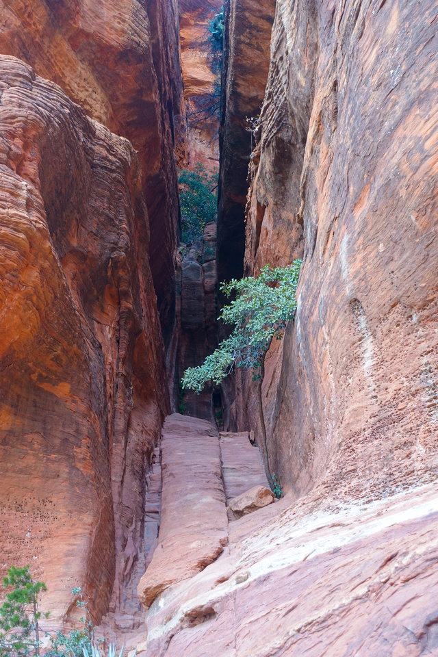
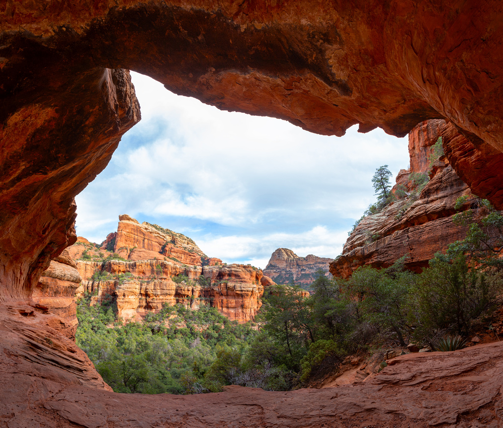
Base of Subway Cave with ~35 degree ramp leading to upper ledge |
|||
| Trip Summary | |||
Dec 12, 2023
Boynton Canyon is one of best known Sedona Trails. There are several points of scenic interest, including (in)famous "Subway Cave" - cave like Slickrock Formation leading to Sinagua ruins on upper shelf. It is also quite popular and you are not likely to have solitude - at Subway at least. Upper Canyon does not see so much traffic as the Subway and offers unique perspective of sheer cliffs with some potential for further exploration.
Trailhead parking is on right side of Enchantment Resort access road, less than a km from Boynton Pass Road junction. As usual with popular Sedona trails space might be hard to find & depending on season / day of week cars can be found on side of the road. Note that only Resort guests can proceed from here. Signed trail rounds the resort on north side; about a km in it is worth checking "Vortex Vista" side trail - you might not feel energy, but bit of aerial views, specially at sunset, will be reward enough. Subway junction is reached about an hour in from the parking. It is not signed, watch for oak tree on left side, see Gallery photo below, Waypoint "2, 4 - Subway Junction", GPS Track download Top of Page. Subway is about 15min from here and will be busy - all kinds of human monkeys clambering the slickrock, posing for selfies and similar nonsense. Despite all this gong show this is awesome place and it would be the shame not to visit. Scrambling up the ramp is not as easy as you might think and I witnessed pathetic individual not being able to descend on all 4 and desperately screaming for help. Main drag of the Subway is upper shelf with awesome cave (Gallery) and couple of Sinagua dwellings. Find trail to the left and easily hike some eroded rock - far better (and safer) option compared to slanted staircase.
Back to main trail turn right and in much more peaceful surroundings hike to Boynton Top. Official Trail end is ~45min from Subway Junction and marked by wooden sign, advising not to go further to prevent erosion. I found little perch just above and enjoyed very peaceful 15-20min enjoying awesome cliffs with black streak made by seasonal waterfall before returning back. Be on alert for javelinas - they are not afraid of humans and are even known to sometime attack; Bear Spray is prudent accessory regardless where you hike. |
|
Gallery |
|||
 Trailhead Signpost
Direction Sign near Parking Lot at end of Boynton Canyon Road Trailhead Signpost
Direction Sign near Parking Lot at end of Boynton Canyon Road |
|||
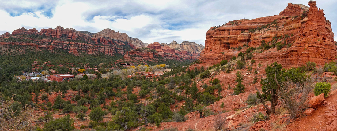 Vortex Vista
Panorama from "Vortex Vista", short side trip from main trail, overlooking Enchantment Resort Vortex Vista
Panorama from "Vortex Vista", short side trip from main trail, overlooking Enchantment Resort |
|||
|
|
|||
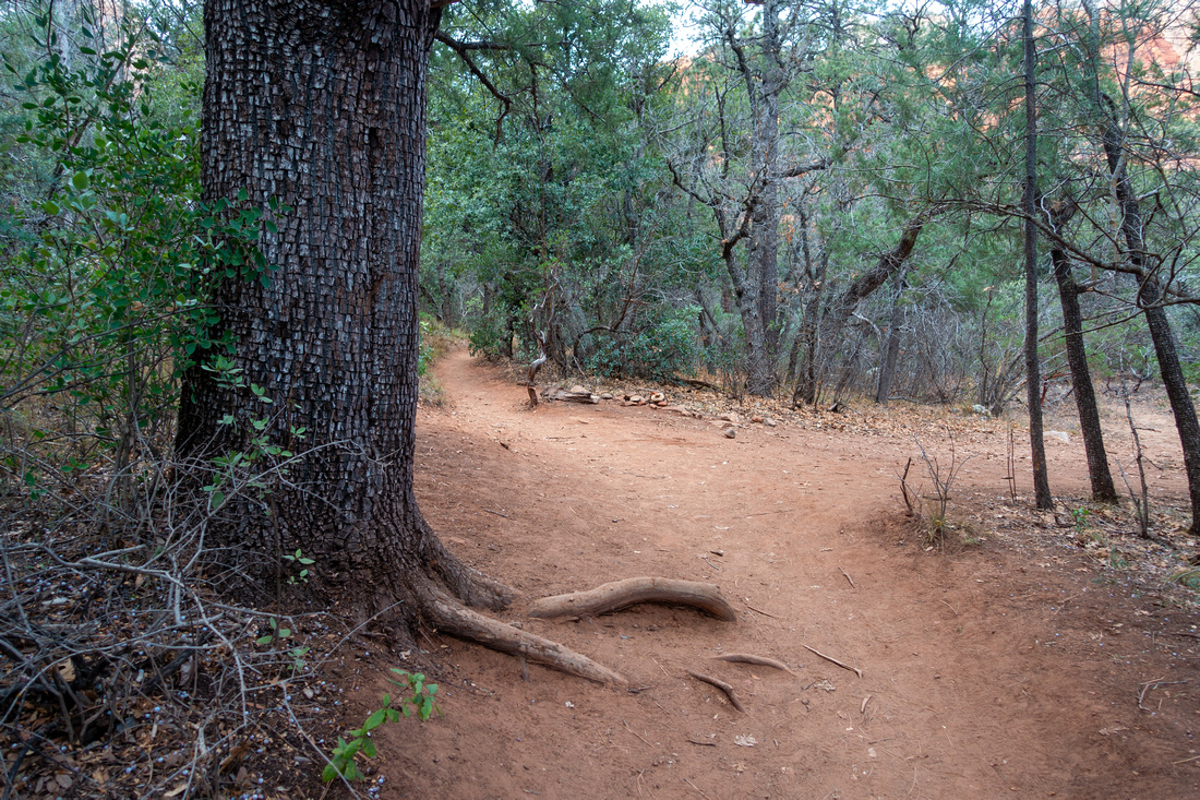 Subway Junction
Unsigned junction about an hour from Trailhead - Right for Subway, straight for Boynton Canyon Subway Junction
Unsigned junction about an hour from Trailhead - Right for Subway, straight for Boynton Canyon |
|||
|
Claustrophobic "Subway", about 15min from the Junction. Slanted Staircase Angle is ~35 degrees and steeper from what this photo suggests. Exposed shelf leading to Sinagua Ruins upper left corner |
|||
|
|
|||
 Subway Shelf
Slickrock Edge at upper part of Subway. If climbing the Staircase you can walk around considerably exposed corner center right; it is far better to climb via eroded trail on previous photo as fall would kill Subway Shelf
Slickrock Edge at upper part of Subway. If climbing the Staircase you can walk around considerably exposed corner center right; it is far better to climb via eroded trail on previous photo as fall would kill |
|||
|
Taking a break Inside shallow cave on Subway Shelf |
|||
 |
|||
 Sinagua Ruins
Sinagua dwelling on upper Shelf. Even such awesome sites are not respected - dumb moron (digitally removed in Photohop) was sitting inside and using gas stove to cook whatever; apparently there is no end to human stupidity Sinagua Ruins
Sinagua dwelling on upper Shelf. Even such awesome sites are not respected - dumb moron (digitally removed in Photohop) was sitting inside and using gas stove to cook whatever; apparently there is no end to human stupidity |
|||
 Upper Canyon
Hiking Picturesque upper Canyon past Subway Junction Upper Canyon
Hiking Picturesque upper Canyon past Subway Junction |
|||
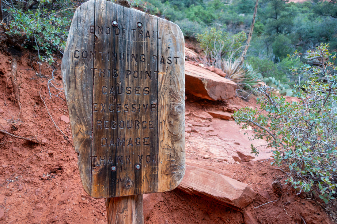 Trail End
End of official Boynton Canyon trail in upper Canyon. It is possible to scramble another 60-80m vertical for better view but progress becomes increasingly more difficult the higher you go Trail End
End of official Boynton Canyon trail in upper Canyon. It is possible to scramble another 60-80m vertical for better view but progress becomes increasingly more difficult the higher you go |
|||
 Seeping Waterfall
Dried out Waterfall guarding top of Boynton Canyon. Penetrating upper plateau from here is highly technical Seeping Waterfall
Dried out Waterfall guarding top of Boynton Canyon. Penetrating upper plateau from here is highly technical |
|||
 Boynton Canyon
Upper Canyon falling in shade from little perch at official Trail End Boynton Canyon
Upper Canyon falling in shade from little perch at official Trail End |


Abstract
| Overall Difficulty | D3/4 | Easy trail hiking for the most part. Class 3 scrambling (avoidable) in Subway. Steep trash above official trail end at top of the Canyon | |||
| Scenery | Slickrock formations, Subway cave and awesome wall at top of the Canyon | ||||
| Trail/Marking | Very Good | Official Sedona Trail with Trailhead Map. Subway junction not marked. | |||
| Suggested Time | 5 hrs | Return time Including Vortex Vista and Subway Side Trips | |||
| Elevation | Start: 1380m Max: 1600m Total: ~300m | Round Trip: 12km | |||
| Gear | Light hikers are sufficient | ||||
| Water | Creek crossing at Subway junction; no reliable source in upper Canyon. Carry 1L or more, depending on season | ||||
| Dog Friendly | Yes | Popular trail - dogs must be kept on leash. Standard desert travel precautions. | |||
 Boynton Canyon GAIA Map
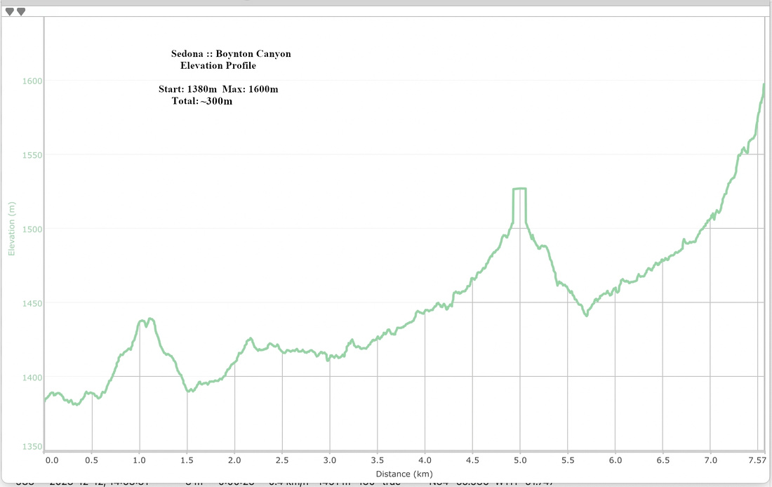 Boynton Canyon Elevation Profile