Google Map |
USA :: San Diego ::Blue Sky - Lake Poway |
GPS Track |
|
Beautiful late Afternoon sunlight reflecting of Mt. Woodson and calm water of Lake Poway |

| Trip Summary | |||
Multiple Dates, last January 26, 2024
Lake Poway is great San Diego County Inland Resource; besides providing water supply for the Residents it also offers Fishing and many other recreational opportunities. Adjacent Blue Sky Ecological Preserve is home to typical Southern California plant species as well as many bird types, some coming over from North to spend winter. Combining these 2 areas yields very satisfactory moderate Hike, as presented on this page. Main recreation area, managed by City of Poway, is open year round 6am - Sunset. Same applies to Blue Sky Trailhead on Espola road. That practically means if you leave the car inside and go hiking, you might find yourself locked out. This rather silly rule can easily be dodged by street parking in one of adjacent residential areas, as I've done many times. (If you still decide to use main Lake Poway Rec area, be aware of non-resident entrance fee -- another argument for Residential approach).
Blue Sky Preserve Road is actually Lake Ramona access road. It is followed for 20-25min to signed junction; go right, then after passing through the fence and by Picnic Area come to junction (Waypoint "2, 5 - Lake Poway Loop"). You can go either way but I find CW direction preferable and this is how Gallery photos are organized. Trail makes couple of wide switchbacks before cresting above the Dam, then descends on the other side reaching Mt. Woodson junction within an hour from Trailhead. Just before this junction is awesome little Gazebo - wood structure with sweeping views across the Lake, and perfect spot for lunch break. Continuing on the other side trail rises up short but steep Hill, then descends on the west side to main Recreation area which is usually the busiest spot in the Park. Visitor center has small concession where refreshments can be purchased. Find trail behind the building that follows west side of the lake offering several great viewpoints before descending to Blue Sky junction where Lake loop is closed; hike back to Blue Sky Trailhead the same way you hiked in. Alternatively one can also walk out on Lake Poway Road to Espola road, then walk on pavement back to wherever you left the Car.
|
|
Gallery |
|||
 Blue Sky Kiosk Blue Sky Kiosk Trailhead Kiosk at top of Blue Sky Preserve Parking Lot on Espola Drive
 |
|||
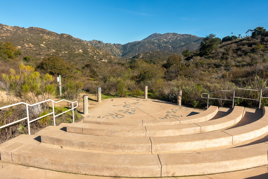 Blue Sky Amphitheater
Small Amphitheater at Toretto Outlook where Park Rangers sometime give presentations on Weekends Blue Sky Amphitheater
Small Amphitheater at Toretto Outlook where Park Rangers sometime give presentations on Weekends |
|||
 |
|||
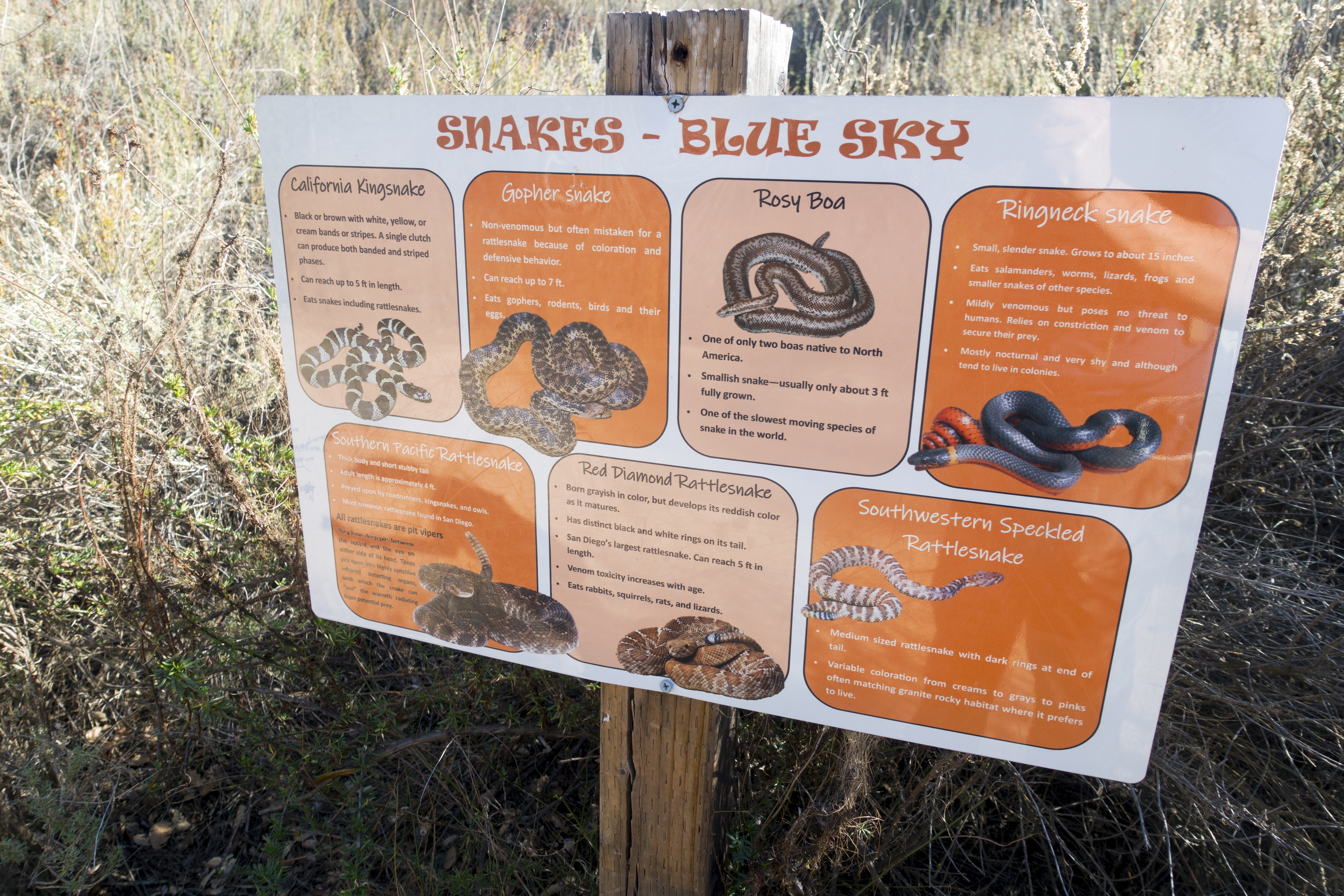
 Nature Conservation
If only more outdoor enthusiasts would follow these Instructions Nature Conservation
If only more outdoor enthusiasts would follow these Instructions |
|||
 Lake Ramona Junction
 ~half an hour from Blue Sky Trailhead. Turn right for Lake Poway Lake Ramona Junction
Lake Ramona Junction ~half an hour from Blue Sky Trailhead. Turn right for Lake Poway |
|||
 Picnic Area
Small Picnic Area few minutes past Lake Ramona junction Picnic Area
Small Picnic Area few minutes past Lake Ramona junction |
|||
 Poway Loop Junction
Loop Junction above the Picnic area. Continue up trail for Clockwise Loop Poway Loop Junction
Loop Junction above the Picnic area. Continue up trail for Clockwise Loop |
|||
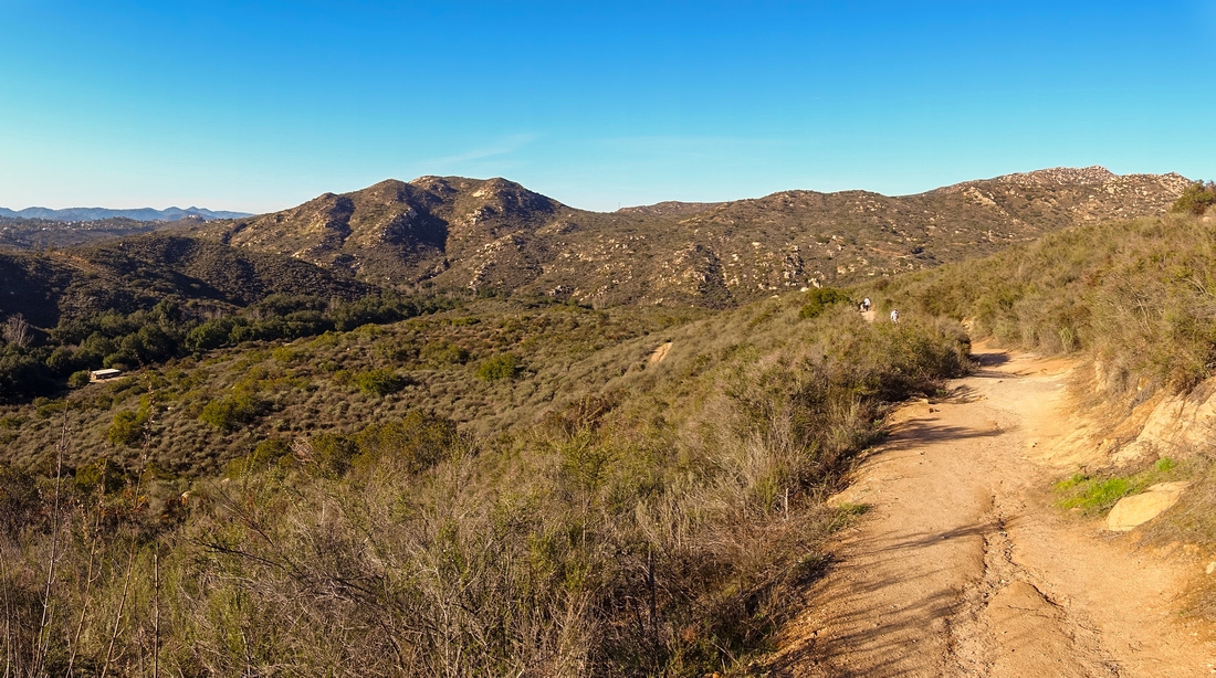 Blue Skyline
Looking back down gentle switchbacks as trail rises towards crest of Lake Poway Dam. Blue Sky Preserve is Canyon stretching left - right roughly center of photo. Picnic Area restrooms is white structure extreme center left Blue Skyline
Looking back down gentle switchbacks as trail rises towards crest of Lake Poway Dam. Blue Sky Preserve is Canyon stretching left - right roughly center of photo. Picnic Area restrooms is white structure extreme center left |
|||
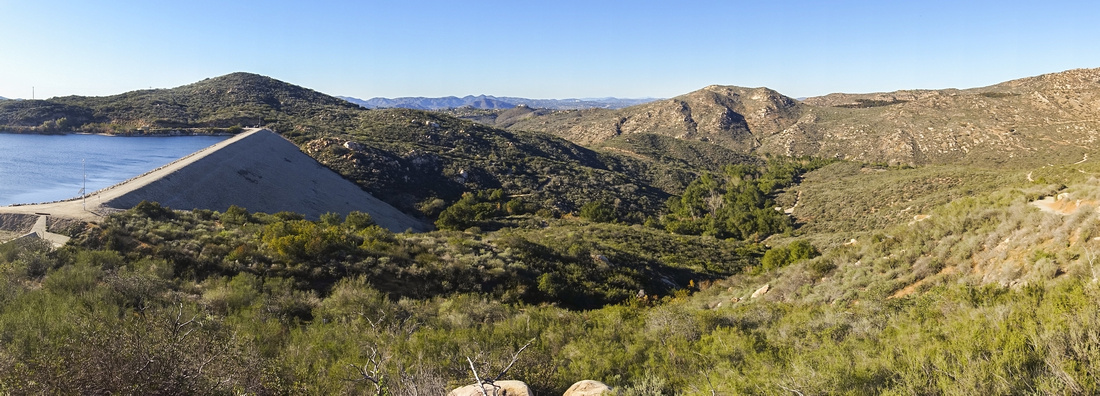 Lake Poway Dam
Westerly Panorama as Trail crests above Lake Poway Dam Lake Poway Dam
Westerly Panorama as Trail crests above Lake Poway Dam |
|||
 Lake Poway Gazebo
Landmark Wooden Gazebo near Mt. Woodson Junction; old burned in 2007 wildfires and was replaced with current one. I spent many hours sitting here over the years and it is one of personal favourite viewpoints in San Diego County Lake Poway Gazebo
Landmark Wooden Gazebo near Mt. Woodson Junction; old burned in 2007 wildfires and was replaced with current one. I spent many hours sitting here over the years and it is one of personal favourite viewpoints in San Diego County |
|||
 Lake Poway
Aerial view over Lake Poway as south side Trail reaches crest of small Hill. Gazebo viewpoint right of center midground, main rec area in the background on the other side Lake Poway
Aerial view over Lake Poway as south side Trail reaches crest of small Hill. Gazebo viewpoint right of center midground, main rec area in the background on the other side |
|||
 Black Ducks
Colony of Black Ducks at main Rec area beach and Boat launch. Many different species of Waterfowl make Lake Poway home Black Ducks
Colony of Black Ducks at main Rec area beach and Boat launch. Many different species of Waterfowl make Lake Poway home |
|||
 Feeding Time
American Coots swarming on the Beach as Visitors often feed them Feeding Time
American Coots swarming on the Beach as Visitors often feed them |
|||
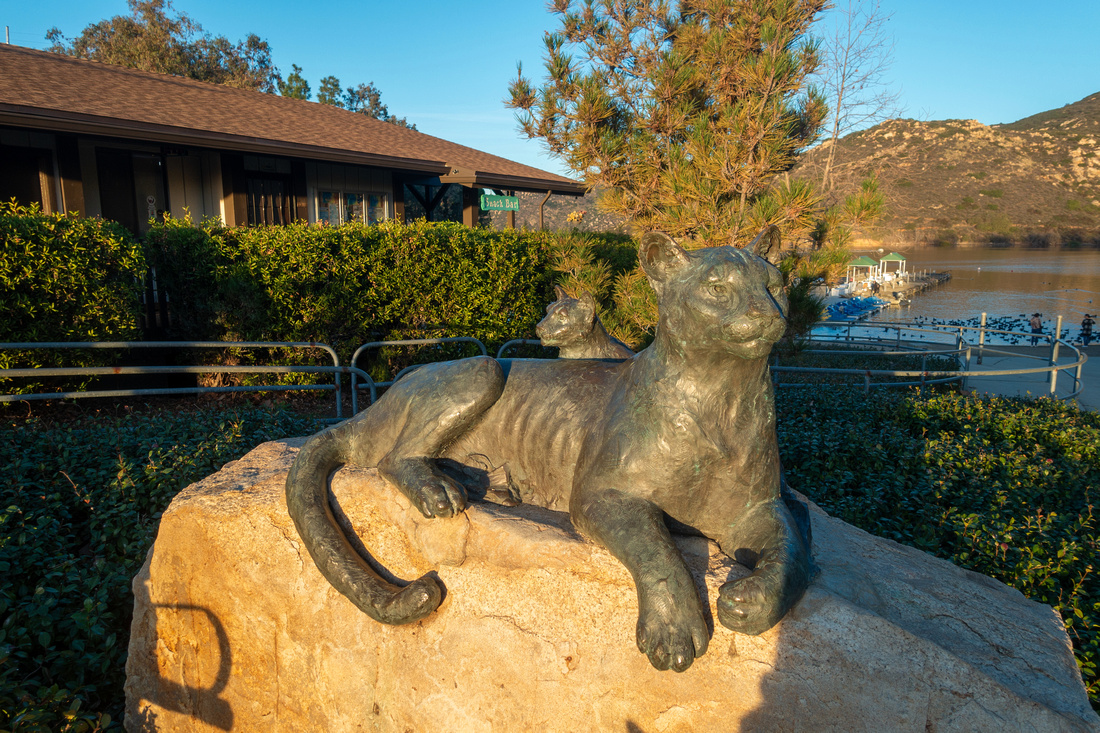 Visitor Center
Main Visitor Center with Cougar Statue Visitor Center
Main Visitor Center with Cougar Statue |
|||
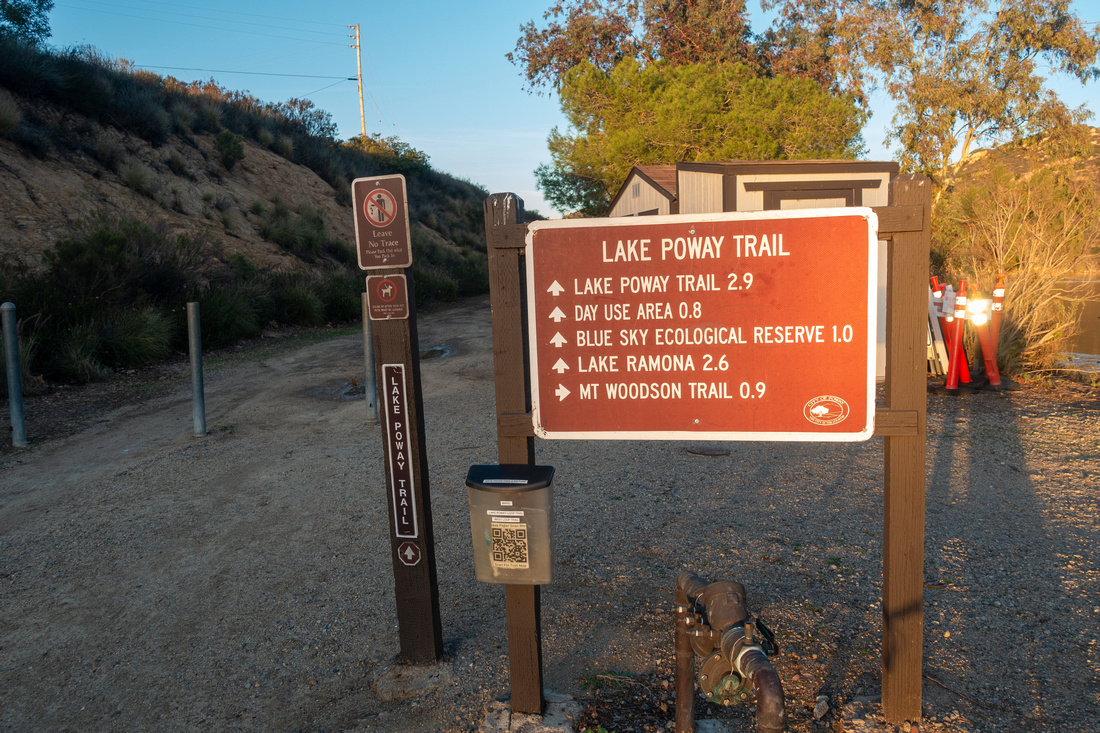 Visitor Center Junction
Lake Poway Trail continues on the other side; Distances are naturally in Miles Visitor Center Junction
Lake Poway Trail continues on the other side; Distances are naturally in Miles |
|||
 Lake Poway Panorama
There are several nice viewpoints on west side of the Lake Lake Poway Panorama
There are several nice viewpoints on west side of the Lake |
|||
 Dam Base
View at Lake Poway Dam base just before closing the Loop Dam Base
View at Lake Poway Dam base just before closing the Loop |
Abstract
| Overall Difficulty | D2/3 | Couple of moderately steep sections with rocky steps | |||
| Scenery | Blue Sky Natural Preserve with typical Coastal vegetation and Bird Species. Many vantage points of Beautiful Lake Poway. | ||||
| Trail/Marking | Excellent | Well defined trail maintained by City of Poway with marked junctions | |||
| Suggested Time | 4hrs | Full loop with Blue Sky Start/End. Lake Poway can be hiked in less than hours when starting at Visitor Center | |||
| Elevation | Start: 220m Max: 330m Total: ~300m | Round Trip: ~10km (Blue Sky OnB) | |||
| Gear | Day Hikers are sufficient | ||||
| Water | Water fountain at Lake Poway Recreation area and Concession. Carry ~1L or more depending on season | ||||
| Dog Friendly | Yes | Dogs should be leashed as this is popular trail. Beware of rattlesnakes in season and keep control | |||
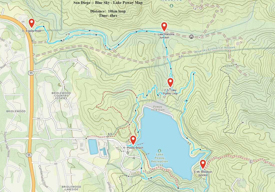 Blue Sky - Lake Poway GAIA Map
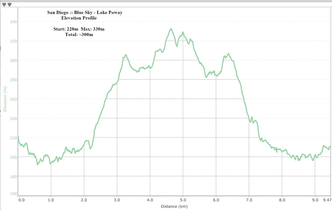 Blue Sky - Lake Poway Elevation Profile