Google Map |
Rockies :: Kananaskis :: Invincible Lake - Mt. Nomad |
GPS Track |
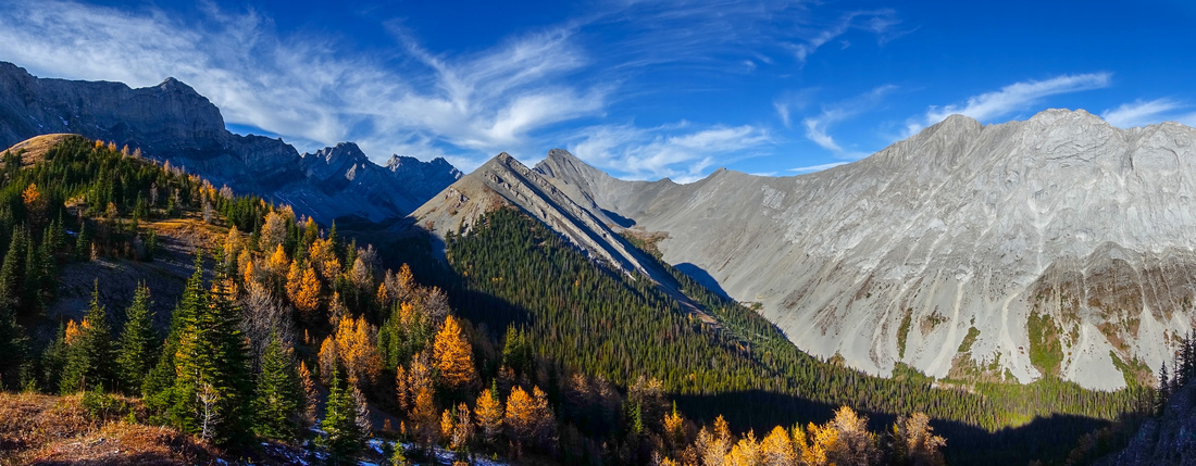 
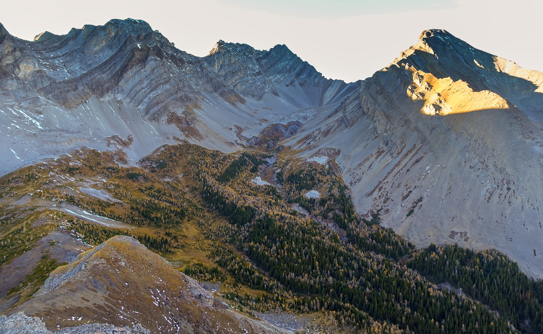
Panorama from larch dotted ridge into secluded valley flanked by Hermione Peak(L), Mt. Warspite(C) and Mt. Invincible (R). Mt. Nomad center midground |
|||
| Trip Summary | |||
Multiple Dates, last Oct 13, 2024Seldom visited high alpine valley ringed by Forks and Hermione Peaks, Mt. Warspite and Mt. Invincible. Mt. Nomad resembling a cone rising in the middle of the cirque above Invincible Lake is non-technical, but getting there is not for casual hikers that need trails. Despite being listed in Kananaskis Trail Guide, entire outing past Invincible creek bridge ~4km from Interlakes parking is still pretty much a route. Chief difficulties are bushwhack on old forest road, followed by very steep ascent of ridge and subsequent drop into the Valley. Area is grizzly bear haven - extra level of caution is advised. Cirque falls in shade rather early; early start is advised if you want sunny views, specially in rapidly dwindling Autumn daylight hours.
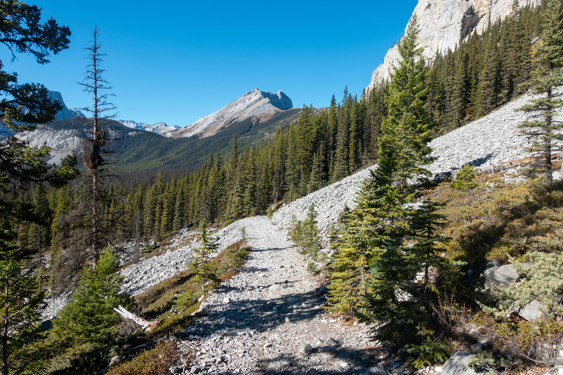
Cycling is allowed to Invincible Creek crossing; this bit is also on Great Divide Trail (GDT). Parts are fairly rocky and I don't believe taking a bike is really worth as dismounting will likely be required several times for average cyclist. It will take about an hour of fast walking; the adventure starts here. Cross Invincible Creek bridge and immediately turn right (Waypoint '1 - Invincible Creek', GPS Download Top of Page). Follow creek upstream very shortly and find trail that is actually old overgrown forest road. Hiking up this road is likely the crux of the day - many fallen logs you must hop over or crawl under, as well as occasional extreme bush where you must protect your eyes. Bushwhack here after rain would be really miserable! It is only about a km, but it will feel much longer - took me almost half an hour till I reached clearing and obvious cairn marking start of Ridge route (see Gallery, Waypoint '2 - Invincible Trail').
Ridge trail is quite well defined and free of bush - but steep. There are no switchbacks, just straight up gaining ~460 vertical in ~1.2km! Trail becomes bit less defined higher up, but still connects all the way to ridge crest; it will take solid hour from the bushy road. Take a note of point where you crested the ridge as it will help find the trail on return - Waypoint '3 - Ridge'). Lots of larches around would make this fairly nice Autumn Golden Larch Trip. Turn left and follow ridge crest for short time only to little saddle, 10min tops. Faint trail descends diagonally into Invincible Lake drainage, but is very easy to miss - use GPS Waypoint '4 - Valley Trail'. Trail is narrow and not hands-in-your-pockets requiring balance (hiking poles are huge help) until eventually diminishing in Invincible Lake Drainage (water). From here going finally becomes easy. If going just for Nomad simply ascend semi-open forest to south talus slope and scramble easily to final summit ridge leading to top of Mt. Nomad. I prefer to visit Invincible Lake first then ascend from there. Either way, be really vary of grizzly bears; both times I've been here I've seen lots of diggings (but no bears).
From Nomad summit is possible to descend North Ridge then loop back around Invincible Lake. Talus is more lose and steep, and there is one short cliff band but overall not difficult. Exploring Top of Valley below Hermione Peak is another possibility, but this extension would add 1-2 hours to already long day - early start would be a must. Return follows the same way across the ridge; reaching Invincible Creek Bridge after the bushwhack will feel like a blessing. |
|
Gallery |
|||
 Interlakes
Crossing the Embankment separating Upper and Lower K-Lake with view of Mt. Lyautey Interlakes
Crossing the Embankment separating Upper and Lower K-Lake with view of Mt. Lyautey |
|||
 Palliser Slide
One of several rock slides along upper K-Lake Trail. High ridge below Forks Peak barring access to Invincible Valley upper center Palliser Slide
One of several rock slides along upper K-Lake Trail. High ridge below Forks Peak barring access to Invincible Valley upper center |
|||
 Invincible Creek
Reaching Invincible Creek ~4km from Interlakes - cycling not allowed from this point (sign). Right after crossing the bridge go sharp right Invincible Creek
Reaching Invincible Creek ~4km from Interlakes - cycling not allowed from this point (sign). Right after crossing the bridge go sharp right |
|||
 Ridge Junction
Cairn marking start of Ridge Trail after ~25min of horrible bushwhack on overgrown forest road Ridge Junction
Cairn marking start of Ridge Trail after ~25min of horrible bushwhack on overgrown forest road |
|||
 Ridge Junction
View back from Ridge Junction (Waypoint '2 - Invincible Trail'). Mt. Indefatigable upper center Ridge Junction
View back from Ridge Junction (Waypoint '2 - Invincible Trail'). Mt. Indefatigable upper center |
|||
 Ridge Trail
Steep but reasonably well defined trail ascending the hillside gaining ~460m vertical in ~1.2km Ridge Trail
Steep but reasonably well defined trail ascending the hillside gaining ~460m vertical in ~1.2km |
|||
 Upper K-Lake
Terrific views of Upper K-Lake are great reason to stop frequently for breather. Mt. Sarrail upper right Upper K-Lake
Terrific views of Upper K-Lake are great reason to stop frequently for breather. Mt. Sarrail upper right |
|||
 Larch Ridge
Faint trail traversing larch dotted ridge for short time only before descending into the valley. Mt. Nomad center Larch Ridge
Faint trail traversing larch dotted ridge for short time only before descending into the valley. Mt. Nomad center |
|||
 Invincible Lake
 Outlet after steep descent from the ridge and hike up canyon draining the lake. If going just for Mt. Nomad it is not necessary to go all the way to the lake, but it would be a shame as it is very scenic. Invincible Lake
Invincible Lake Outlet after steep descent from the ridge and hike up canyon draining the lake. If going just for Mt. Nomad it is not necessary to go all the way to the lake, but it would be a shame as it is very scenic. |
|||
 Invincible Lake
Ascending grassy meadows above Invincible Lake towards Mt. Nomad south slope Invincible Lake
Ascending grassy meadows above Invincible Lake towards Mt. Nomad south slope |
|||
 Nomad Talus
Moderately steep talus provides uncomplicated ascent route. Aim just left of pointy tooth upper center for most stable route Nomad Talus
Moderately steep talus provides uncomplicated ascent route. Aim just left of pointy tooth upper center for most stable route |
|||
 Nomad Slope
Looking back around halfway up Mt. Nomad. Descent into the valley slices down from the ridge roughly center Nomad Slope
Looking back around halfway up Mt. Nomad. Descent into the valley slices down from the ridge roughly center |
|||
 Invincible Lake
View down to Invincible Lake from upper Nomad ascent slope Invincible Lake
View down to Invincible Lake from upper Nomad ascent slope |
|||
 Nomad Ridge
Final Ridgewalk to Nomad summit cairn is very enjoyable but short. Shapely Mt. Warspite behind Nomad Ridge
Final Ridgewalk to Nomad summit cairn is very enjoyable but short. Shapely Mt. Warspite behind |
|||
 Mt. Indefatigable
View back to Mt. Indefatigable (C) from Nomad summit ridge. Mt. Invincible upper left - clearly not a scramble Mt. Indefatigable
View back to Mt. Indefatigable (C) from Nomad summit ridge. Mt. Invincible upper left - clearly not a scramble |
|||
 Nomad Register
Ever present Pink Register at Mt. Nomad Summit Nomad Register
Ever present Pink Register at Mt. Nomad Summit |
|||
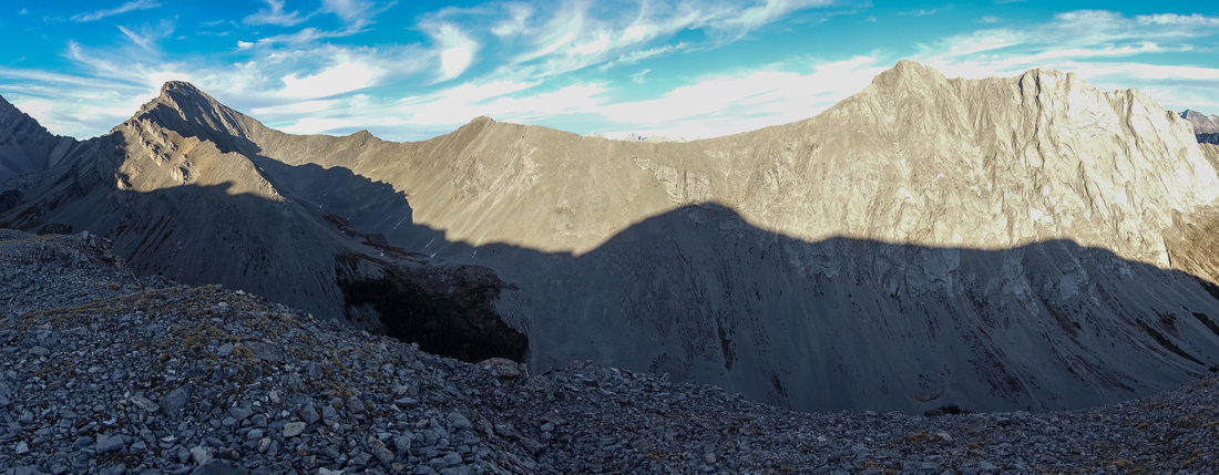 Invincible Ridge
Ridge between Mt. Warspite (L) and Mt. Invincible (R) is more than just a scramble Invincible Ridge
Ridge between Mt. Warspite (L) and Mt. Invincible (R) is more than just a scramble |
|||
 |
|||
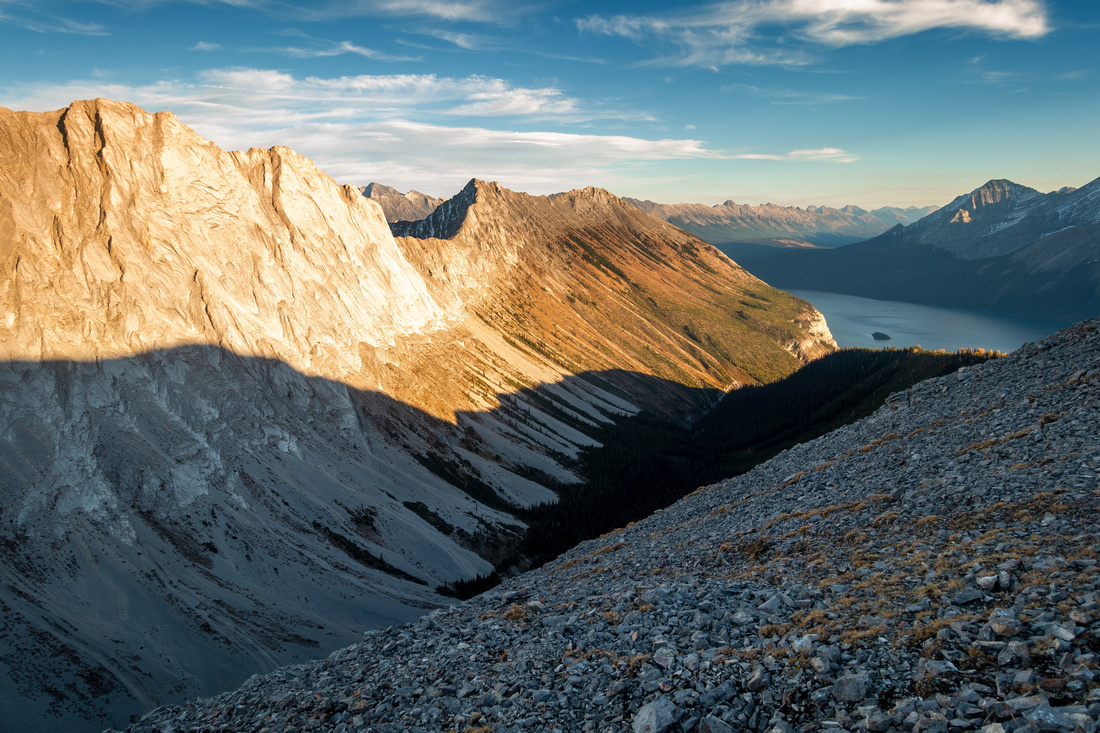
 Warspite Bowl
View down north ridge of Mt. Nomad. Descent this way is bit more challenging, but offers loop around Invincible Lake on return. Extremely rarely visited head of larch dotted valley below Hermione Peak begs for further exploration Warspite Bowl
View down north ridge of Mt. Nomad. Descent this way is bit more challenging, but offers loop around Invincible Lake on return. Extremely rarely visited head of larch dotted valley below Hermione Peak begs for further exploration |
|||
 K-Lake Moondawn
Full moon rising over upper Kananaskis Lake just before starting steep ridge descent on return K-Lake Moondawn
Full moon rising over upper Kananaskis Lake just before starting steep ridge descent on return |
Abstract
| Overall Difficulty | D5 | Tedious bushwhack on old forest road. Very steep slope leading to the ridge. Talus Scramble for Mt. Nomad (class 2 at most). Considerable total elevation due to all ups and downs. Routefinding | |||
| Snow Factor | S3 | Steep slope either side of the Ridge would pose considerable avalanche danger. Invincible Lake likely never visited in winter conditions | |||
| Scenery | Great Aerial views of upper Kananaskis Lake. Beautiful Invincible Lake. Rugged Invincible - Indefatiguable Ridge. Larch dotted alpine valley below Mt. Warspite / Hermione Peak | ||||
| Trail/Marking | Poor | Wide and well defined trail to Invincible Creek; route with occasional cairns/flags afterwards | |||
| Suggested Time | 8 hrs | Return time for Mt. Nomad with moderate pace. Add 1-2 hrs for exploring Warspite Bowl north of Invincible Lake | |||
| Elevation | Start: 1730m Max: 2560 m Total: ~1390m (return) | Round Trip: ~17km (add ~2-3km for Warspite Bowl) | |||
| Gear | Full Hiking Boots a must. Gaiters and Poles. Long Pants/Sleeves (bushwhack). GPS Essential | ||||
| Water | Invincible Creek and Invincible Lake Outlet, none in between. Carry 1-1.5L depending on season | ||||
| Dog Friendly | Yes | Standard back-country travel precautions. Invincible Lake alpine environs are prime grizzly bear area | |||
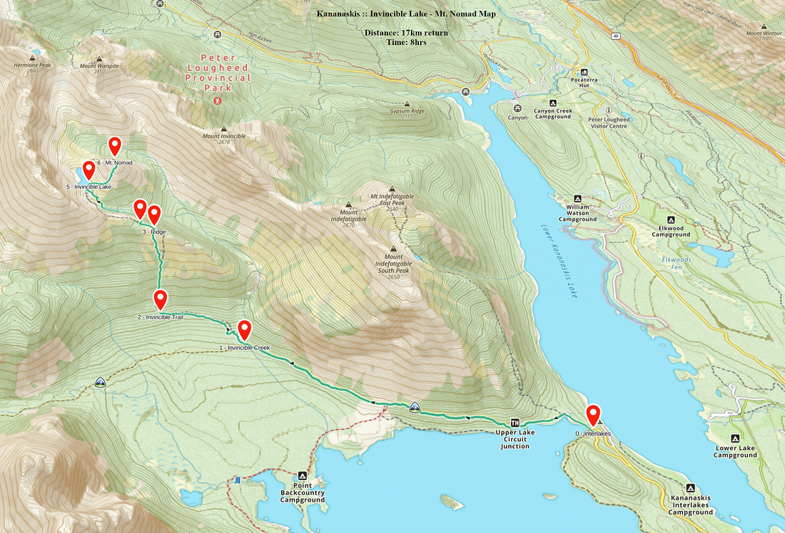 Invincible Lake - Mt. Nomad GAIA Map
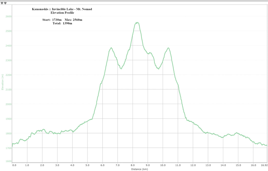 Invincible Lake - Mt. Nomad Elevation Profile