Google Map |
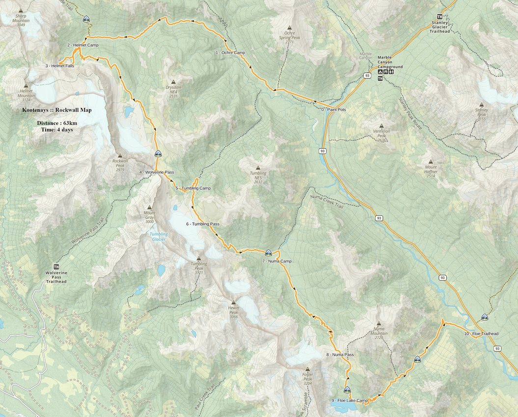
Rockies :: Kootenays :: The Rockwall |
GPS Track |
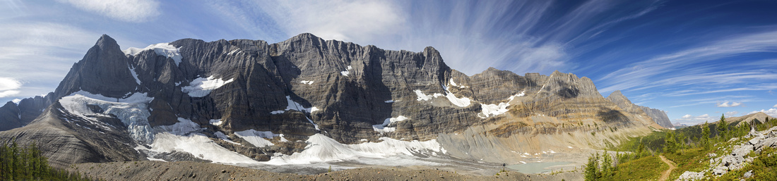 
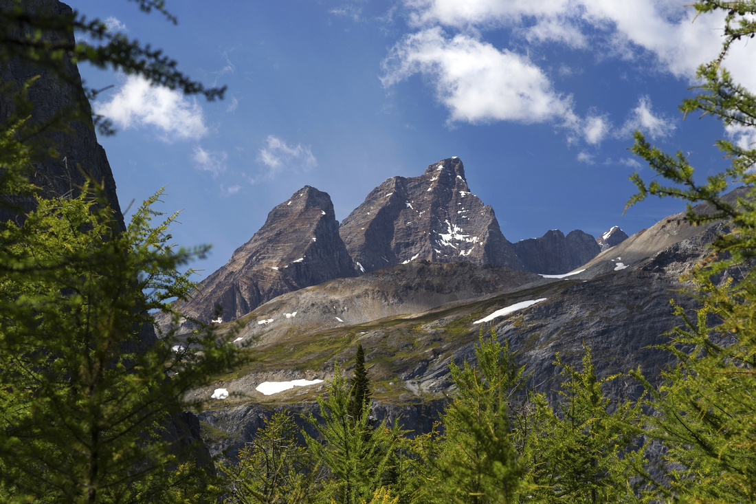
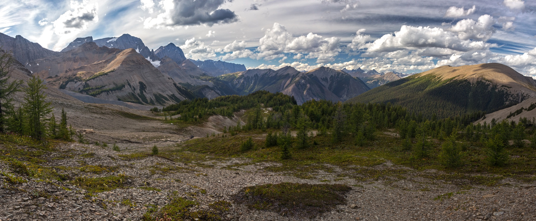
Panoramic View of The Rockwall and Tumbling Glacier from Tumbling Pass |
|||
|
Rockwall is classic Rockies backpack. It is named by 30+ km massive limestone escarpment towering above some of most impressive alpine scenery Rockies have to offer, including glaciers, meadows, waterfalls and lakes. All this doesn't come without the price; roller-coaster nature with steep drops into intervening valleys that must be climbed on the other side put considerable burden on backpacker. Some people day-hike parts of Rockwall - and some even trail-run the whole thing - but, besides physical endurance appeal, this is not optimal way to experience the area. Trail is official and there are 4 (+1) maintained Parks Canada campgrounds -- Helmet Falls, Tumbling Creek, Numa Creek and Floe Lake (+ Ochre Creek). They can be used to spread the journey and leave plenty of time for one of finest back-country experiences Rockies have to offer. In full season trail is popular, so advance reservations via Parks Canada site are recommended. Tip: when sites appear booked, it is worth checking regularly as many people cancel for one reason or the other -- I was able to book 3 nights, including most popular Floe Lake campground, day before the trip in late August - prime backpacking season. If still insisting on day hikes into Rockwall area there are 2 options: 1) Helmet - Tumbling loop, starting and ending in Paint Pots and 2) Floe - Numa loop, with start and end some 5km apart on Hwy93 (Note that Numa creek is closed as of summer '19 as bridge was out and Parks have no firm repair time schedule). Both options are quite strenuous and can not be recommended. Much debate can be found online about the direction: North - South (Floe Lake - Helmet Falls) or the other way around. While it is probably the case of 6 1/2 in one, half-a-dozen in the other, personal preference is Helmet Falls first. Main reason being that all the climbs are in the shade and less steep (in particular horrendous "black hole" drop from Tumbling Pass to Numa Creek, way easier to descend). Other reason that many quote is "leave Floe Lake for last". One of true gems of Canadian Rockies and view of larch filled slopes and sheer escarpment towering above Floe lake from Numa Pass is unforgettable. Other consideration is transport. Distance between trailheads is ~12km along Banff-Radium Highway (Hwy 93). Without two vehicles it is strongly recommended to leave your car at exit trailhead then hitch a ride to start; hiking towards your vehicle is much preferred than worrying about the transport on last day when you are all sweaty and tired! This problem can usually be solved by simply hanging at trailhead for a bit then asking outbound hikers to give you a lift.
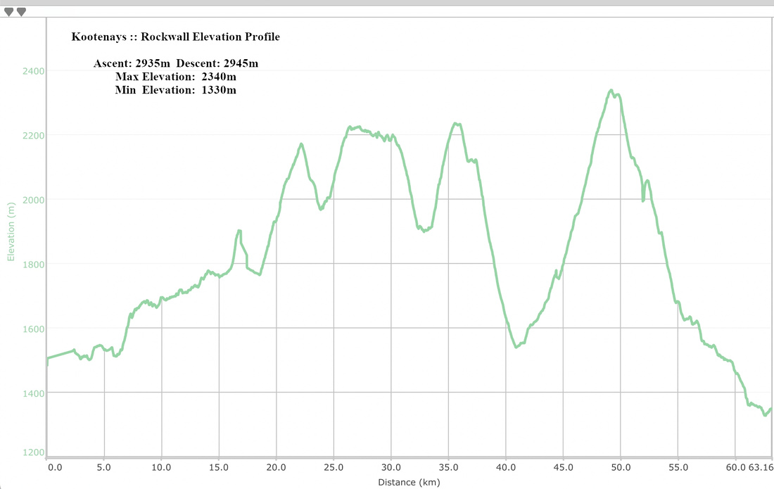
This page presents 4 days/3 nights journey in N-S direction, as per my August 2019 trip. It consisted of following parts:
If time constraints are not an issue, for optimal experience I'd recommend 6 days/5nights trip: 2 nights at Helmet Falls (allowing for day hike with light pack to explore Goodsir Pass), then 1 night at Tumbling Creek, Numa Creek and Floe Lake each.
|
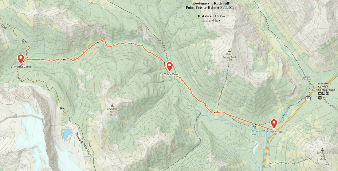
| Paint Pots to Helmet Falls | GPS Track | ||
|
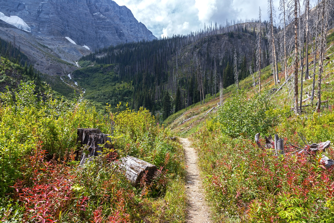
Helmet creek provides north access to the Rockwall. It is much gentler than south Floe Lake trail, and thus better suited for first day journey when backpack is the heaviest. Views are limited but excitement that builds up as you are venturing into such a beautiful area makes up for it. Helmet creek campground is quite nice with first major scenic reward - thundering Helmet Falls, one of highest in Canada, draining west Washmawapta and Sharp Glaciers above. Trailhead is at Paint Pots parking area on north side of Banff-Radium highway (Hwy93), some 20-25 minutes west of Trans-Canada Castle Junction in Banff National Park. Wide trail crosses Vermilion River then meanders through bronze colored Ochre Springs ("Paint Pots") around 1km mark. Tourists usually drop here and trail quietly slips into the forest following east side of Ochre Creek. Mainly flat with minor ups and downs it crosses couple of bushy avalanche slopes, then reaches signed Tumbling Creek junction ~4km mark. (If hiking only Helmet - Tumbling part, this is where you'd close the loop on return). Ochre Creek campground is reached in another 15-20 minutes. Past the campground trail crosses Helmet creek then switchbacks up forested slopes - majority of elevation gain is in this part. After crossing couple more avalanche slopes trail eventually drops to Helmet creek, with glimpses of still distant Limestone Peak and Helmet Falls. Suspension bridge is around 12km mark, and this feature definitely breaks the monotony of the journey -- it sways a lot! It is quite safe but best crossed one person at a time! Finally, after crossing bushy meadow and signed Goodsir Pass junction trail reaches KNP Helmet Creek Ranger Cabin. Campground is on the other side of the creek. Viable option is to spend 2 nights in Helmet Creek camp. This allows for day hike into the Goodsir Pass -- expansive alpine meadow with fantastic view of The Goodsirs - iconic Rockies peaks Twin Towers. It is also possible to trek into Lake O'Hara area this way via Ottertail River, but very few people do this (frequent Parks trail closure + transport logistics). Regardless of the time spent in Helmet camp, trip to base of Helmet Falls is a must. Simply follow trail past the campground to sign that informs you "400m to Helmet Falls viewpoint". Side trail ends at boulder field at bottom of glacial moraine, but one can easily scramble up to the base of the falls. Great view back of Helmet Creek valley you hiked in awaits there. |
|||
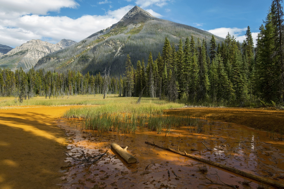 Ochre Springs ("Paint Pots") near the start looking back to Vermilion Peak
 |
|||
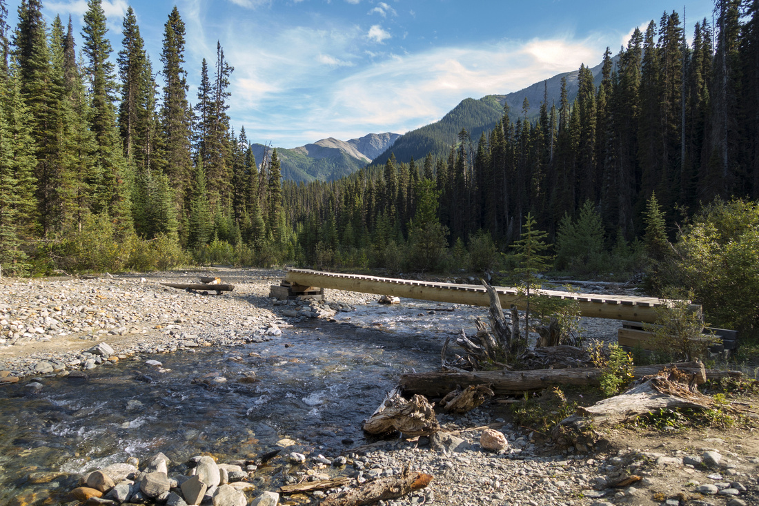 Bridge over Ochre Creek by campground 6km from Paint Pots
 |
|||
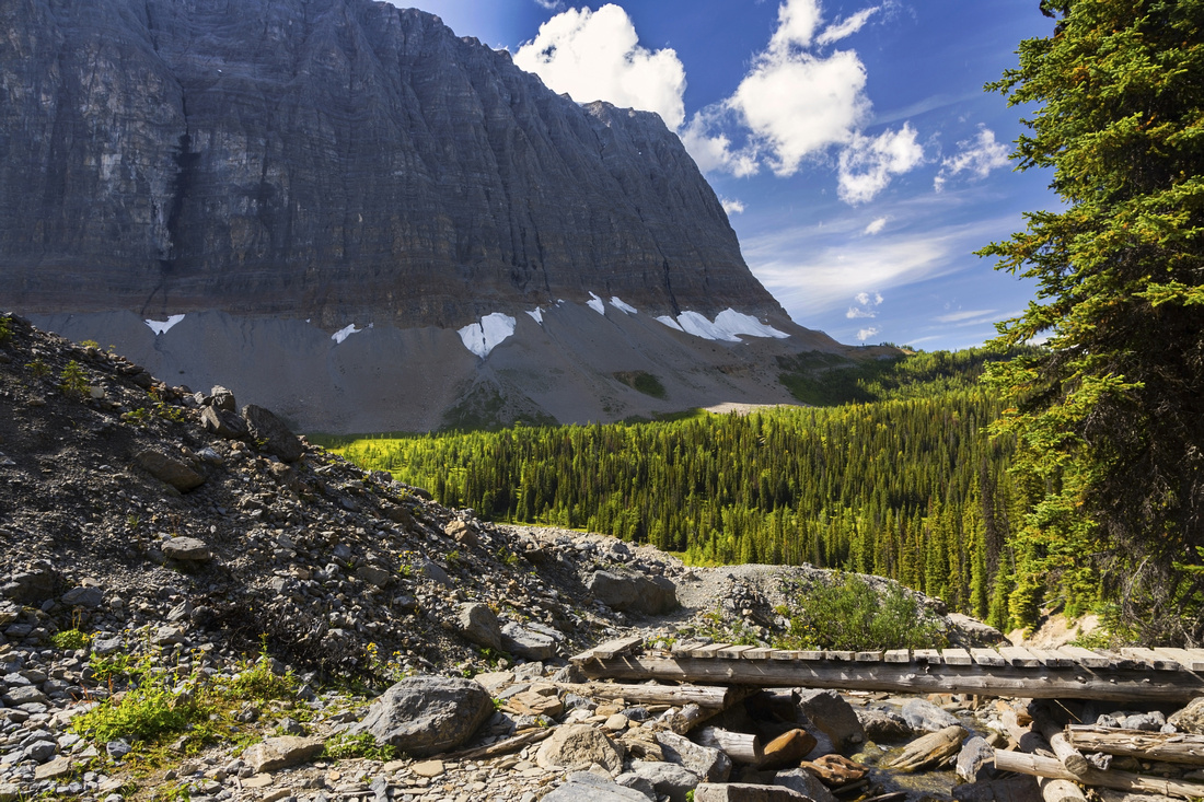
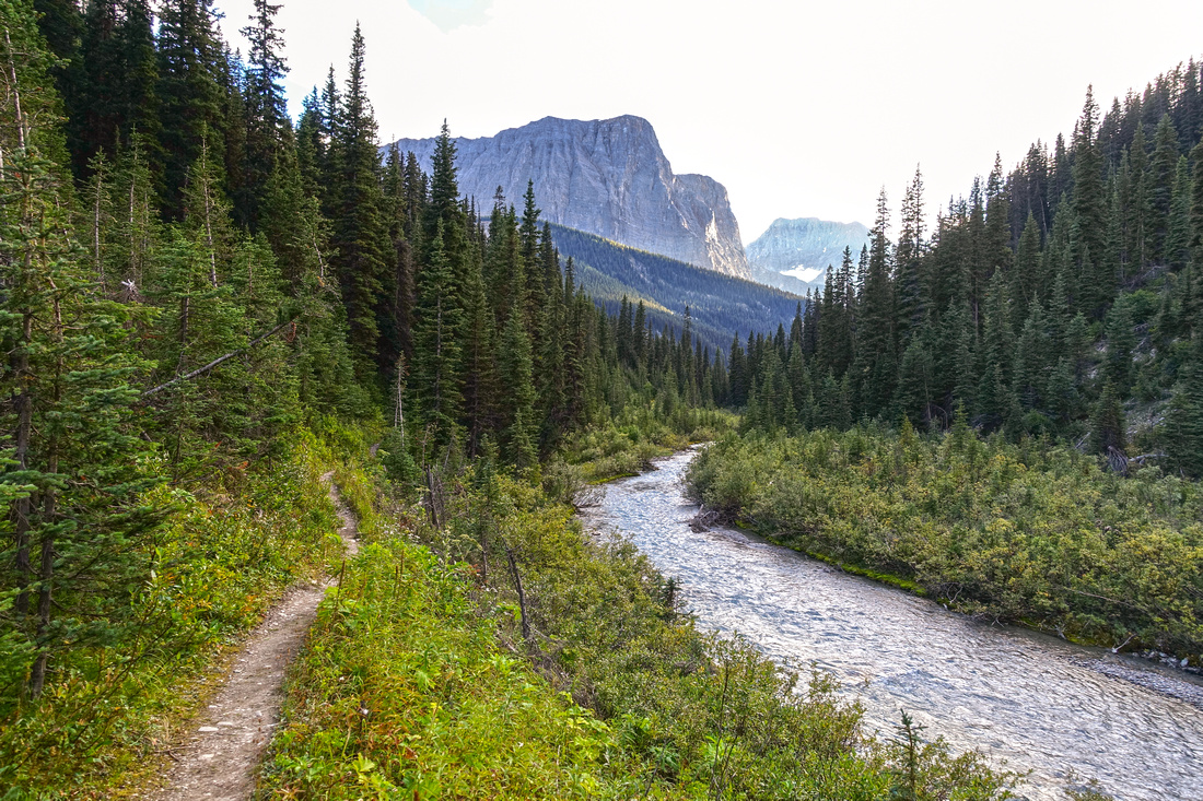 Hiking Helmet Creek Valley around 10km mark. Rockwall trail climbs forested slope below Limestone Peak (distance, center) above Helmet Falls Campground
 |
|||
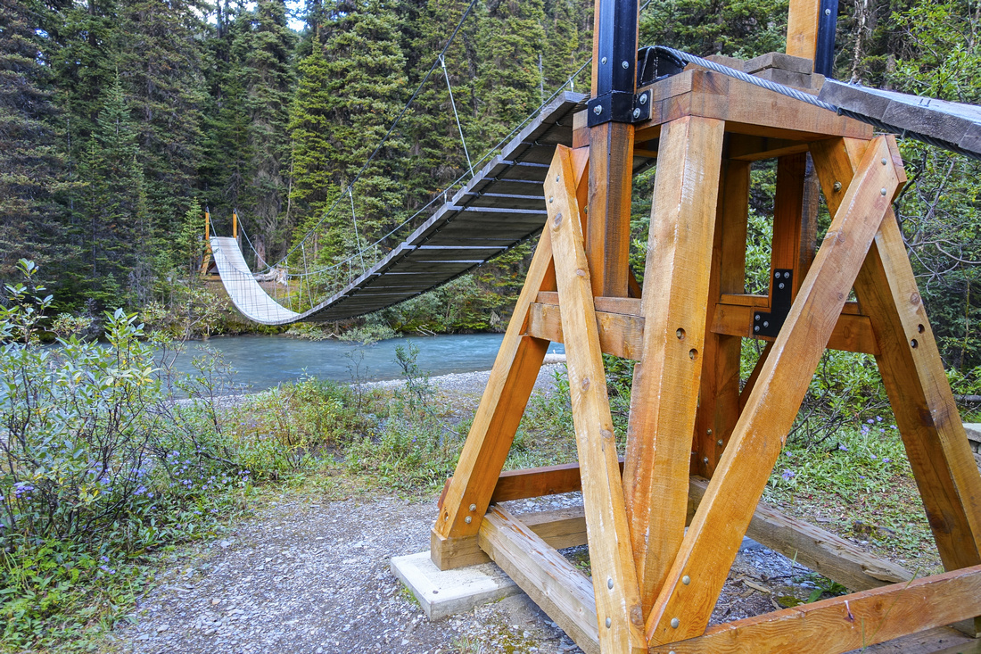 Suspension Bridge ~3km before Helmet Falls campground. It is safe, but cross 1 person at a time
 |
|||
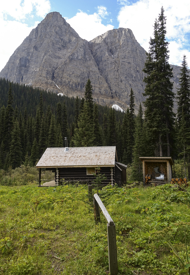 KNP Ranger Cabin in meadows just before Helmet Creek campground. Limestone Peak above
 |
|||
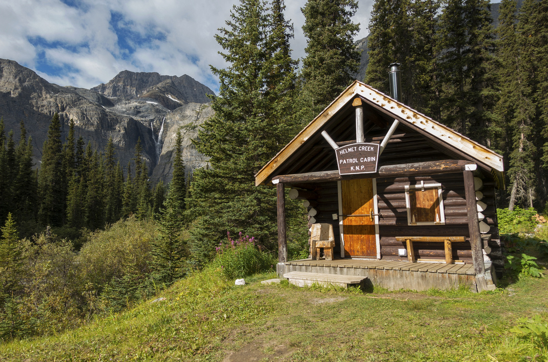 Another shot of KNP Cabin. Park Rangers build their cabins at most awesome places! Helmet Falls distance left
 |
|||
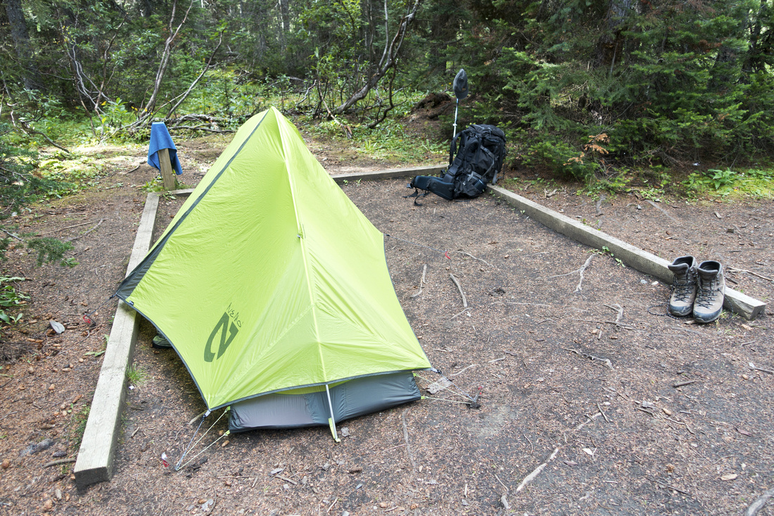 Typical tent pad at Helmet Falls campground. Eating area with food cache is fair distance away
 |
|||
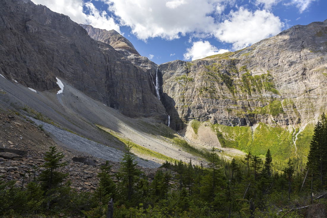
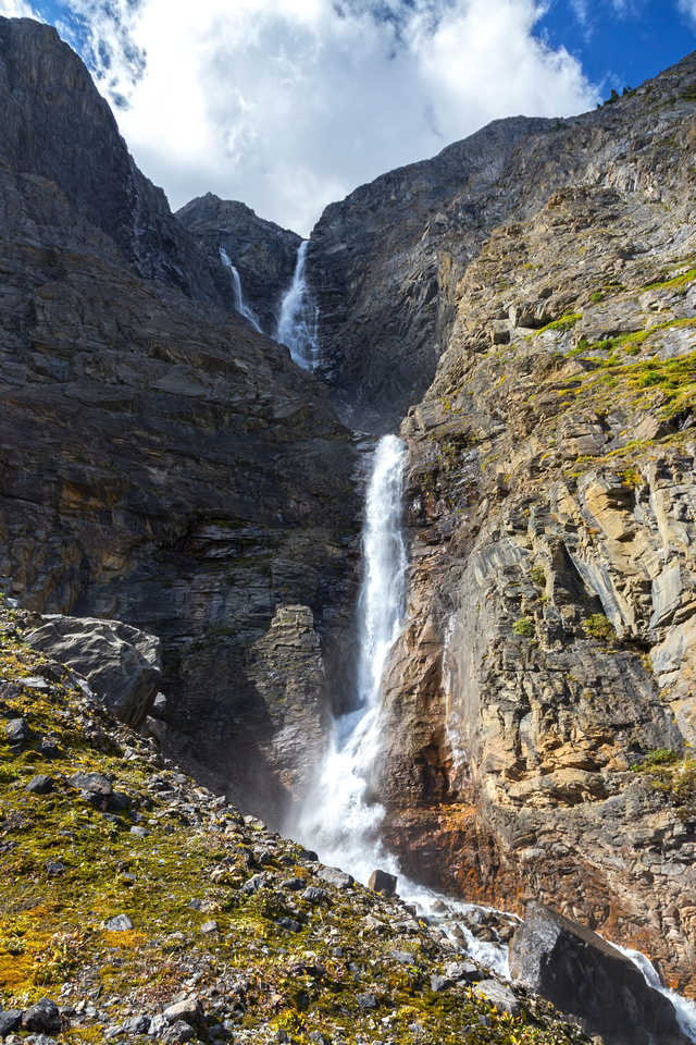 Base of Helmet Falls, about 1km past the campground. Trail vanishes in boulder field 400m past Rockwall trail, but one can easily hike up terminal moraine for a closer look
 |
|||
 View of Helmet Creek valley from base of Helmet Falls
 |
|||
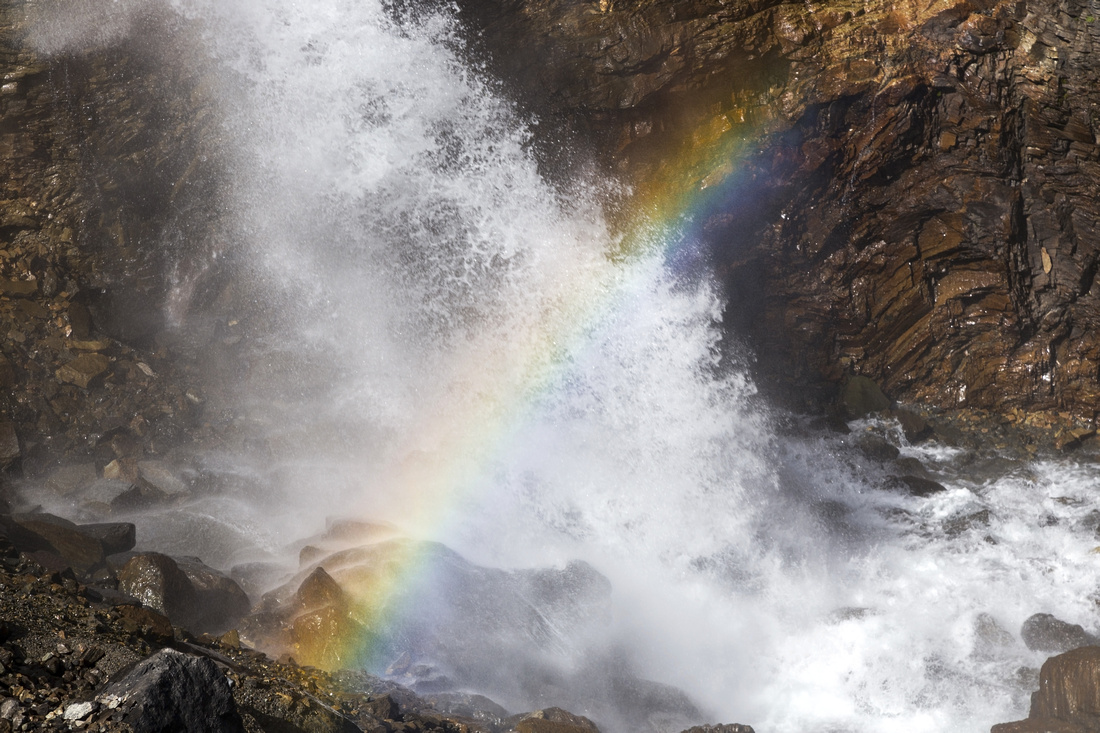 Helmet Falls Rainbow Colors
 |
|||
Abstract
| Overall Difficulty | D3 | Gentle trail hiking with moderate uphill sections in Helmet Creek valley. Several bridged creek crossings | |||
| Snow Factor | S2 | Some danger as Helmet creek trail crosses couple of avalanche gullies | |||
| Scenery | Ochre beds ("Paint Pots") near the start, mostly forest enclosed with some open sections afterwards | ||||
| Trail/Marking | Excellent | Official park maintained trail with bridged creek crossings and marked junctions | |||
| Suggested Time | 5-6 hrs | Easy to moderate pace with heavy overnight backpack. Day-hikers could probably do it in 3-4 hours (1 way) | |||
| Elevation | Start: 1460m End: ~1770m Total: (+550)(-240) | Distance: 15 km | |||
| Gear | Full Hiking boots and Overnight gear. Light hikers would suffice for summer day-hike | ||||
| Water | Ochre and Helmet creeks. Carry no more than 1L | ||||
| Dog Friendly | Yes | Please keep dogs under control as this is prime grizzly bear country and for consideration to other hikers | |||
 Paint Pots to Helmet Falls GAIA Map
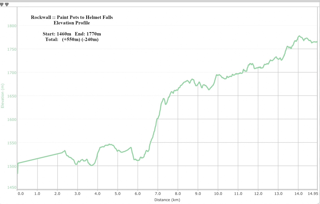 Paint Pots to Helmet Falls Elevation
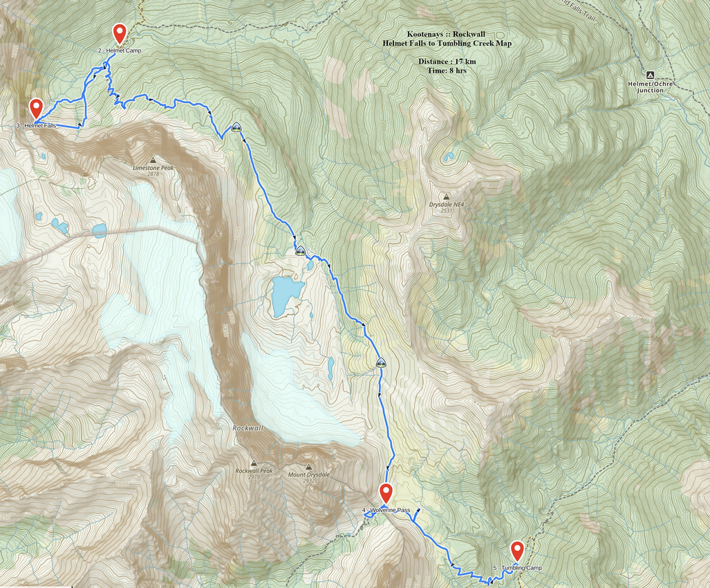
| Helmet Falls to Tumbling Creek | GPS Track | ||
|
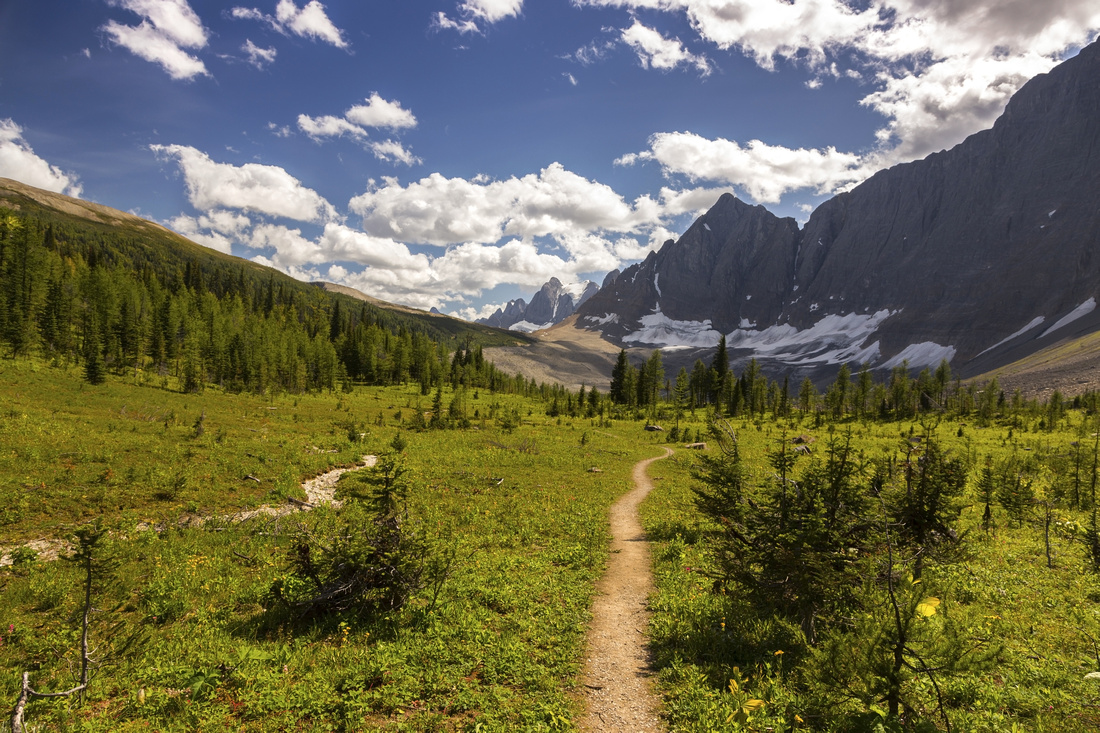
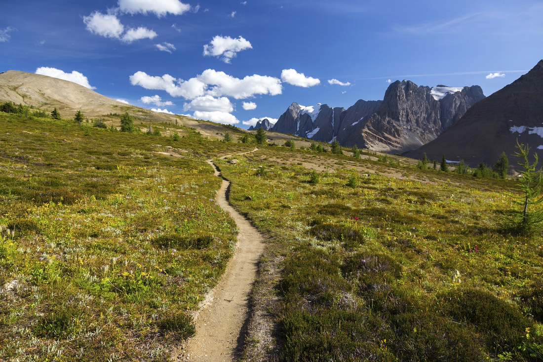
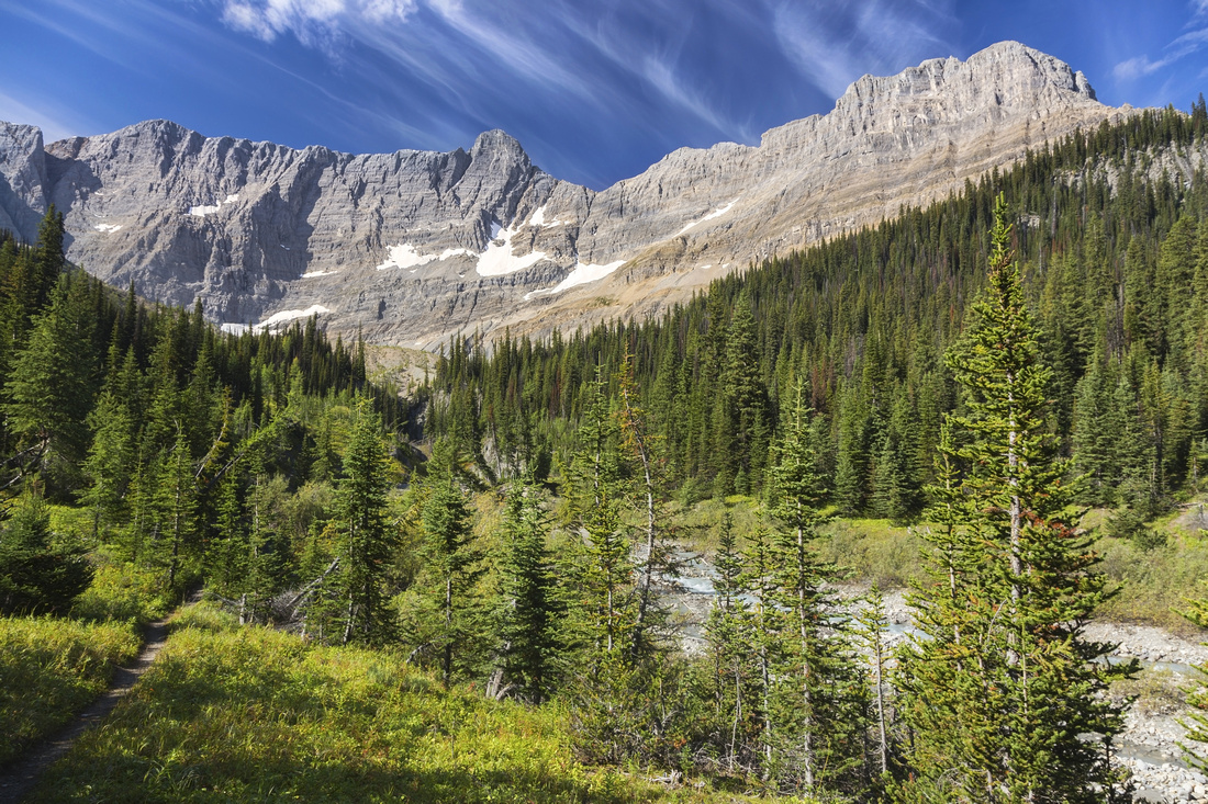
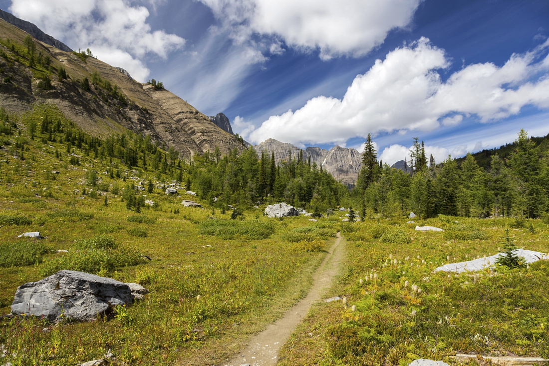
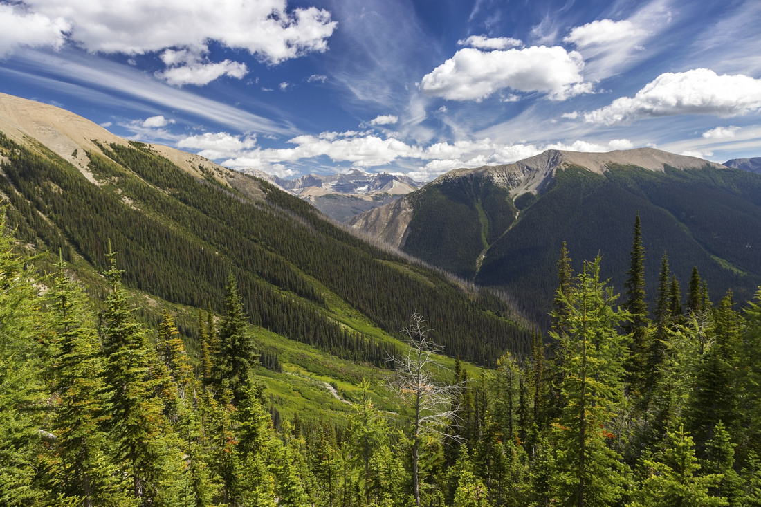
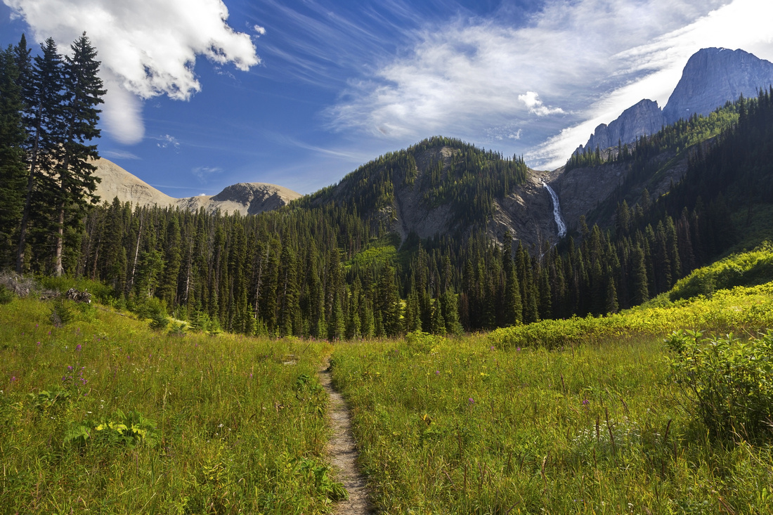
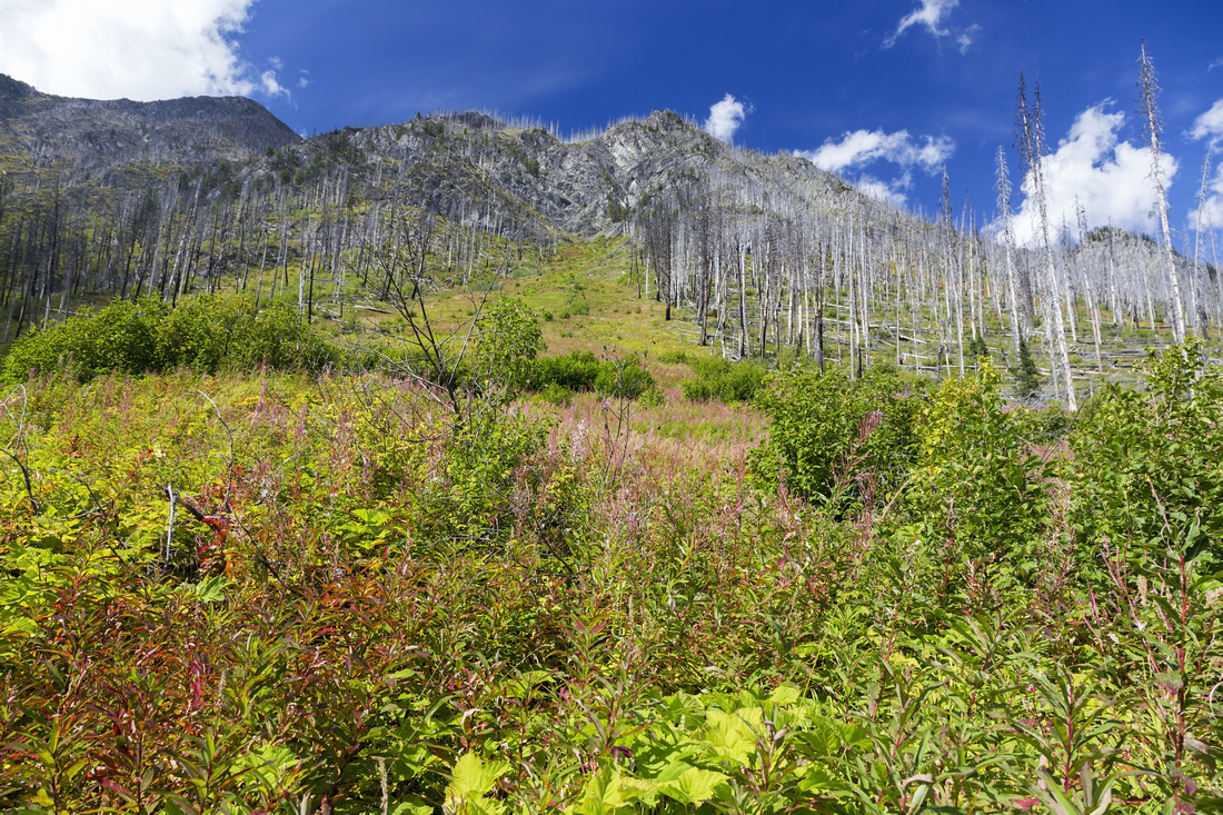
Helmet Falls to Tumbling Creek segment is arguably the most scenic part of the Rockwall trail. It has the longest stretch above treeline and scenery is simply breathtaking, including different perspective of Helmet waterfall, three alpine passes, and one of most expansive alpine meadows in Canadian Rockies. Roller-coaster factor, although present, is not overly taxing as ups/downs are reasonable and incline gentle. In second part of September Limestone summit is also one of best places to enjoy golden larches. Some backpackers do a straight dash from Helmet to Numa, but this simply does not leave enough time to appreciate beautiful scenery; it is far better to overnight at Tumbling creek which is also a very nice campground. Side trips include base of Helmet Falls (if you haven't done it on the first day), wondering west to Wolverine Pass and Wolverine Plateau exploration -- including one of nicest back-country log cabins I have ever seen. From Helmet campground trail switchbacks up forested slopes below Limestone peak to first alpine pass of the day -"Limestone Summit"- gaining ~400m vertical on the way. Approaching the highpoint brimming with larches, make sure you glance back as you are high enough for good view of Goodsir Towers. Trail then descends on the other side and crosses south fork of Helmet Creek, then ascends through moraine towards Rockwall pass. Sizeable glacial tarn can be seen directly below the Rockwall, and could easily be visited (off trail) if one desires. Second half of the ascent to Rockwall Pass is in the forest on nice and easy trail. Then arrives the major highlight -- gorgeous expansive meadows with abundance of wildflowers in mid to late summer! Trail meanders for several kilometers where every step is pure joy, before descending gently towards Wolverine Plateau. Note log cabin in the distance; trail passes above it, but it is more than worth to make a side trip for the visit. Cabin was in use with stove, table & chairs, and bunk bed with mattresses. I was not entirely certain whether this is Outfitter or Parks Canada cabin, and online information is divided. Regardless, it is built in such a fantastic place and waking up there in the morning must feel amazing. Be alert though as these meadows are prime grizzly bear habitat; on my trip huge bruin was feeding not more than 50 m above the trail. He spotted me, snorted and kept feeding -- what a nice bear! From Wolverine Plateau trail descends gradually towards Tumbling Creek -- some 3km or so. Campground is reached about 45min from the cabin. It is larger than you think initially as most of the sites are in the meadow, not forest where you first encountered Camp sign. Tumbling Creek is good, but silty water source as it drains directly from the glacier above. |
|||
 View of Helmet Falls as trail switchbacks forested slope below Limestone Peak
 |
|||
 Peek-a-boo view of Goodsir Towers (center, center-right) and Sentry Peak (center-left) through Larch forest near Limestone Summit
 |
|||
 Beautiful alpine meadows on descent from Limestone Summit. Rockwall Pass distance center
 |
|||
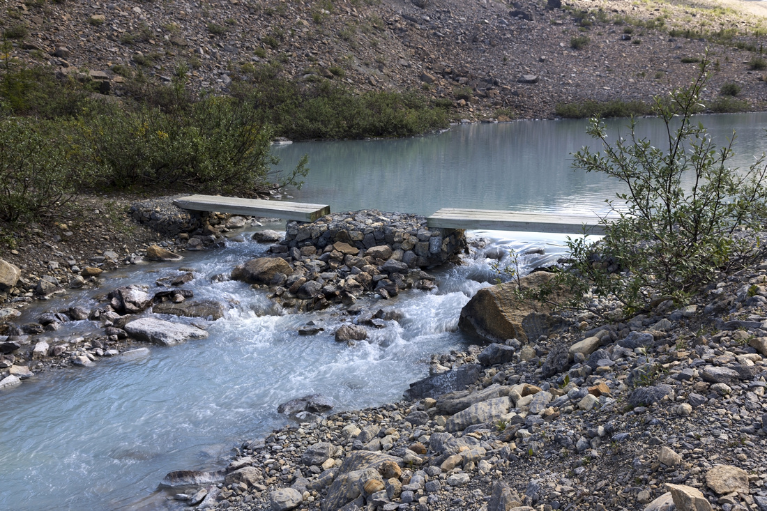 Bridged crossing of glacial tarn outflow and source of Helmet Creek south fork
 |
|||
 View back to Limestone Summit as trail dips into the forest and starts ascent of Rockwall Pass
 |
|||
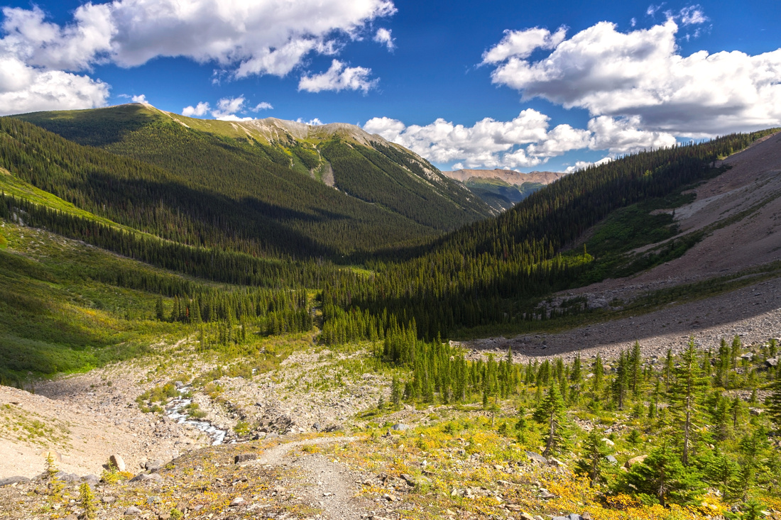
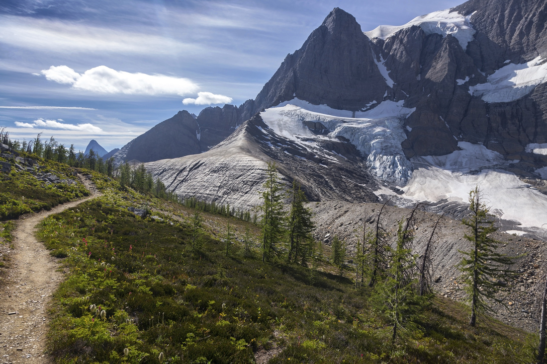
 Rockwall Pass as trail starts gradual descent to Wolverine Plateau. These couple of kilometers are one of most scenic parts of Rockwall Trail
 |
|||
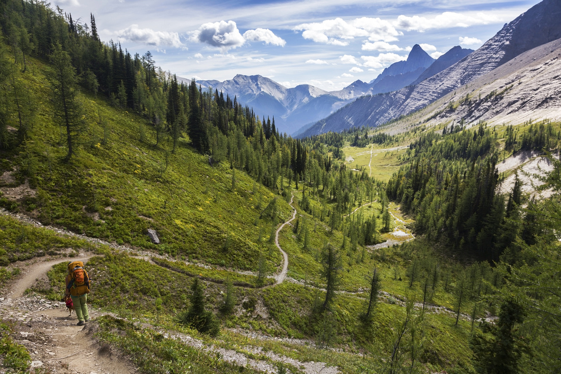
 Descending to Wolverine Plateau. Wolverine Pass center right. Tumbling Pass and glacier center left
 |
|||
 Mount Gray on short side trip on west side of Wolverine Pass. Trail continues into Dainard Creek drainage down to Radium - Golden corridor
 |
|||
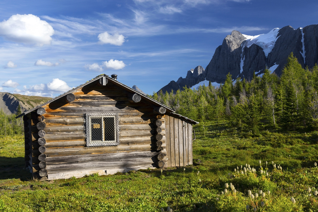 Outfitter -or maybe Parks Canada- cabin in gorgeous meadows south of Wolverine Pass
 |
|||
Abstract
| Overall Difficulty | D3/4 | Trail hiking with couple of steeper ups and downs. Several bridged creek crossings | |||
| Snow Factor | S2 | Low avalanche danger on open slopes below Limestone peak | |||
| Scenery | Helmet Falls Viewpoint. Expansive Larch meadows below Limestone Peak. Rockwall Cliffs. One of most stunning alpine meadows in Canadian Rocky Mountains at Rockwall Pass / Wolverine Plateau | ||||
| Trail/Marking | Excellent | Official park maintained trail with bridged creek crossings and marked junctions | |||
| Suggested Time | 8 hrs | Including Helmet Falls / Wolverine Pass / Outfitter Cabin side trips with leisurely pace | |||
| Elevation | Start: 1770m End: 1910m Total: (+910m)(-760m) | Distance: 17 km | |||
| Gear | Full Hiking boots and Overnight gear. Light hikers would suffice for summer day-hike | ||||
| Water | Helmet Creek south fork between Limestone summit and Rockwall pass. Carry ~1L | ||||
| Dog Friendly | Yes | Please keep dogs under control as this is prime grizzly bear country and for consideration to other hikers | |||
 Helmet Falls to Tumbling Creek GAIA Map
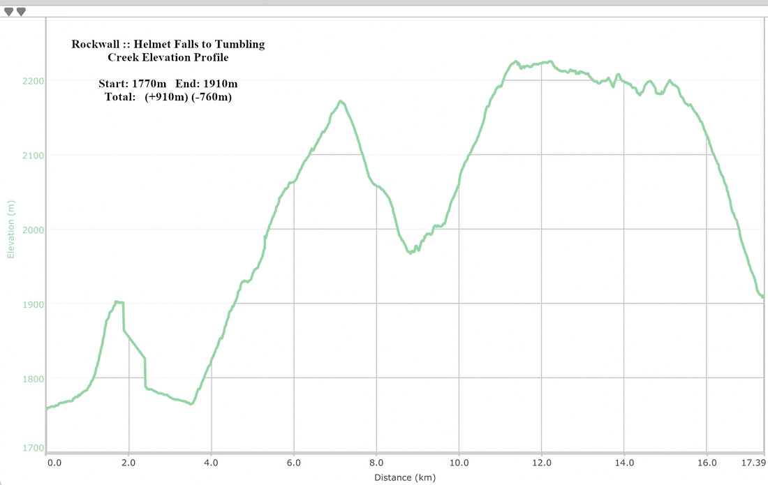 Helmet Falls to Tumbling Creek Elevation
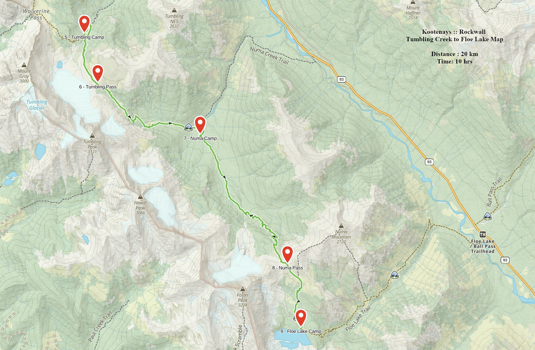
| Tumbling Creek to Numa Creek to Floe Lake | GPS Track | ||
|
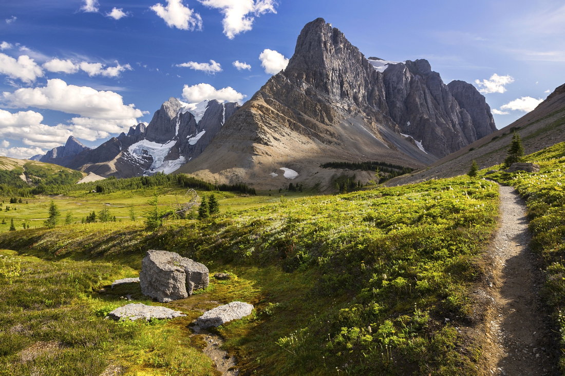
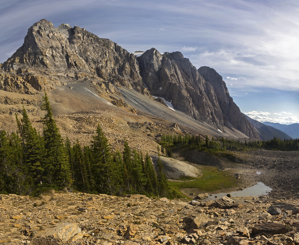
This segment is the most strenuous of the 4. Trail gains ~800m vertical from Numa Creek "black hole" to Numa Pass, so many people decide to split it in 2 by staying extra night at Numa Creek campground. Other option that would fall into "4 days/3 night" itinerary is Helmet Falls - Numa Creek on Day 2 (skipping Tumbling Pass camp), but I'd definitely not recommend this as it also makes for a long day, and limits time on Rockwall Pass/Wolverine Plateau. Also note that drop from Tumbling Pass into Numa Creek is quite steep and for large part in open avalanche slope, where sun be would make climb very tough if you were traversing Rockwall in opposite direction. From Tumbling campground trail descends for couple of minutes to junction with Tumbling Creek trail - alternate entry/exit back to Paint Pots. Cross the bridge then climb to Tumbling Pass. Switchbacks are moderately steep but not long and trail soon exits to gorgeous alpine with spectacular view of Tumbling Glacier. Meadows are not as expansive as on Wolverine Plateau though and before long trail starts steep descent to "black hole" of Numa Creek. It is worth having early lunch here as views are about to be cut off till much later in the day on approach to Numa Pass which looks terrifyingly far away. Switchbacks lead down huge talus slope with couple of unbridged creek crossings, the only one entire Rockwall Trail. By mid / late summer water is usually low enough for easy rock-hop. Eventually trail enters forest and descends to Numa Creek trail junction, some 10 minutes before the campground. Numa Creek is another alternate Rockwall entry/exit, but trail was closed as of summer '19 because of bridge collapse lower down and there were no firm repair schedule so you are pretty much committed to Floe Lake exit by this point. Past the campground trail starts forested Numa Pass ascent. Incline is initially gentle and allows for fast travel. Within an hour trail reaches open meadows and crosses to east side of Numa Creek on a 2-log bridge. This is good spot for a break and to fill water bottle, as real elevation gain is about to start. Switchbacks rise steeply through mixed forest eventually exiting to subalpine larch meadows; final ascent to Numa Pass is on talus. Fabulous views to Floe Lake area from the Pass are unforgettable and, if not windy, this is great spot for extended break - probably much needed by this time. Note trails beaten in scree on left (east) side -- scrambler route up Numa mountain, a straightforward ascent also feasible as day-hike from Floe Lake trailhead. Below the Pass main trail contours meadows on the left side, then drops ~300m vertical through larch forest to Floe Lake campground. |
|||
 South side of Tumbling Creek as Trail starts Tumbling Pass ascent. Campground is on other side of the creek in forested area just right of center
 |
|||
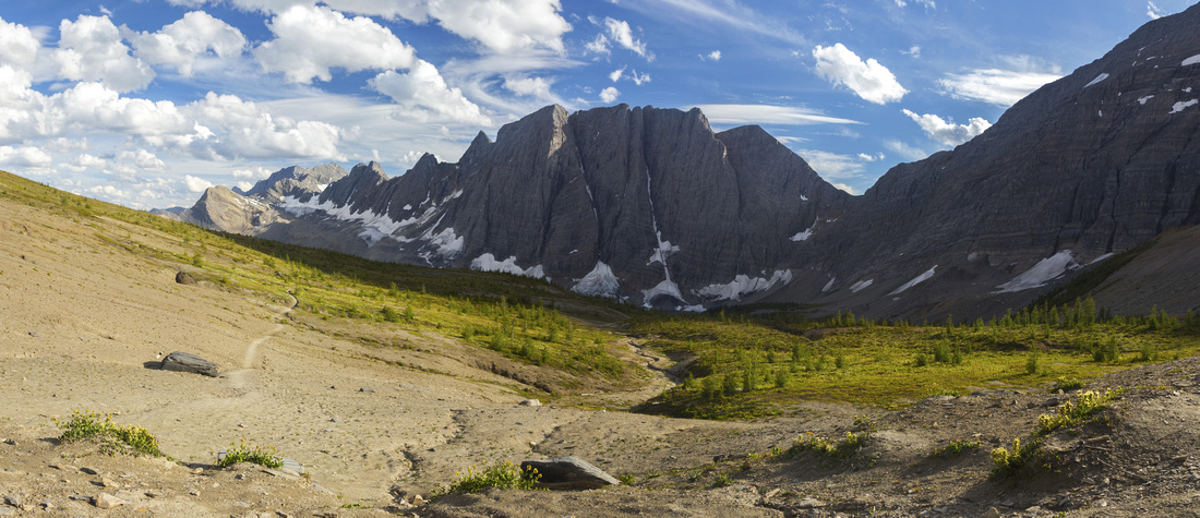
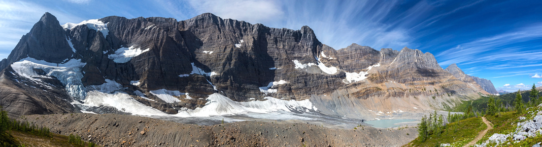 Panoramic View of Tumbling Glacier and Rockwall from Tumbling Pass. Note glacial tarn lower center right -- ultimate source of Tumbling Creek
 |
|||
 Spectacular View of Tumbling Glacier as trail nears Tumbling Pass Highpoint
 |
|||
 Descending Tumbling Pass through stands of larch trees. Numa Pass and pointed cone of Foster Peak distance center right
 |
|||
 Looking back towards Tumbling Pass as trail traverses alpine meadow above "black hole" of Numa creek
 |
|||
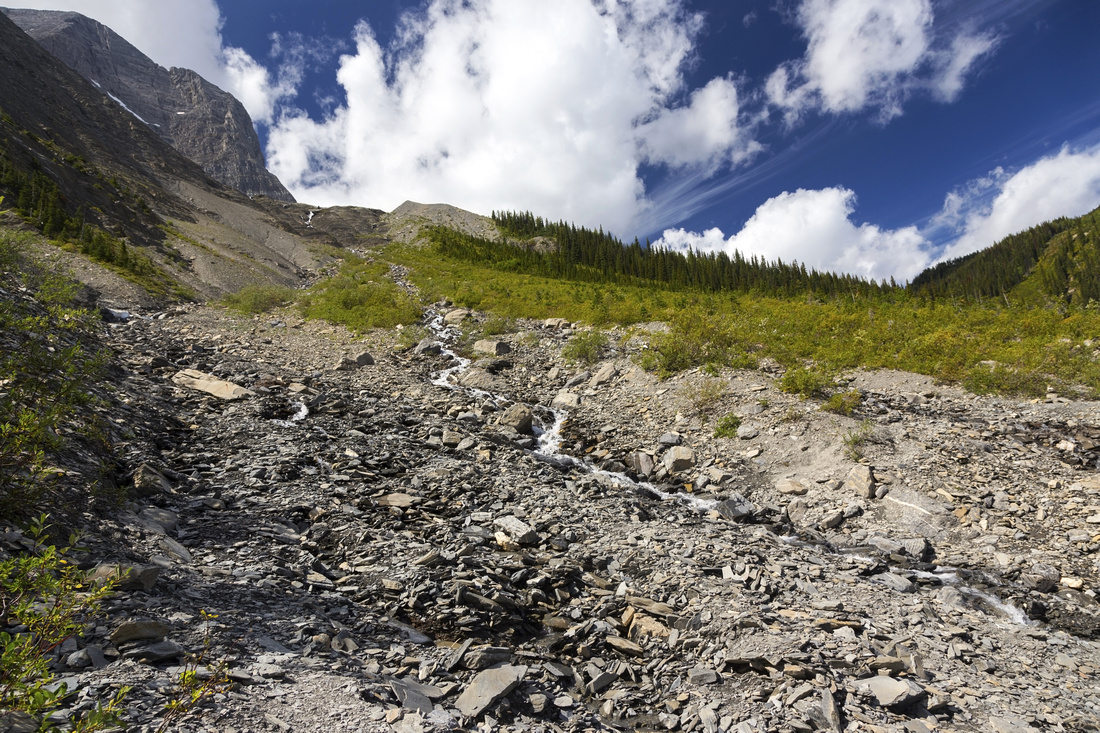
 Starting descent to Numa Creek, far below. Elevation loss from Tumbling Pass is ~700m
 |
|||
 Telephoto of Peaks on east side of Banff-Radium Highway. L-R: Stanley Peak, Mt. Beatrice, Mt. Ball and Isabelle Peak (all Kane scrambles)
 |
|||
 Unbridged creek crossing halfway down. This section would be quite brutal to ascend and is in my mind one of chief reasons why N-S direction is preferred
 |
|||
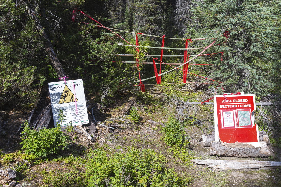 Numa Creek trail junction, some 10 min before the campground -- closed as of summer '2019
 |
|||
 Ascending Numa Pass. These meadows, about 1hr from Numa camp, are good spot for a break as steep part of ascent is about to start
 |
|||
 Final bit of ascent to windswept gap of Numa Pass. ~800m vertical is gained from the campground, but grade is gentler than Tumbling Creek side
 |
|||
 Panoramic view north from Numa Pass. Tumbling Pass just left of center already far away; Limestone Peak (day 2) behind
 |
|||
 Panoramic view south from Numa Pass. Trail circles on the left side of larch alpine plateau below, then descends ~300m vertical to Floe Lake
 |
|||
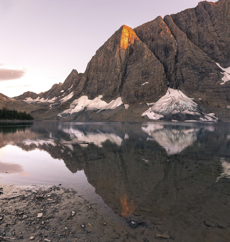 Floe Lake sunset
 |
|||
Abstract
| Overall Difficulty | D4/5 | Considerable amount of elevation gain/loss with some steep and lose sections. One unbridged creek crossing. | |||
| Snow Factor | S3 | Descent from Tumbling Pass into the "black hole" of Numa Creek is on steep and open avalanche prone slopes | |||
| Scenery | Classic Rockwall view from Tumbling Pass (Patton-Robinson guide). Sheer escarpment above Floe Lake and larch meadows at Numa Pass - one of most iconic views in Canadian Rockies | ||||
| Trail/Marking | Excellent | Official park maintained trail with bridged creek crossings and marked junctions. Note: Numa Creek trail was closed as of summer '19 because of bridge collapse | |||
| Suggested Time | 9-10 hrs | Steady pace with heavy overnight backpack | |||
| Elevation | Start: 1910m End: 2040m Total: (+1210m)(-1080m) | Distance: 20 km | |||
| Gear | Full Hiking boots and Overnight gear | ||||
| Water | Couple of drainages on descent from Tumbling Pass. Numa Creek. Upper half of Numa Pass ascent is with no reliable water source and steep -- carry 2L | ||||
| Dog Friendly | Yes | Please keep dogs under control as this is prime grizzly bear country and for consideration to other hikers | |||
 Tumbling Creek to Floe Lake GAIA Map
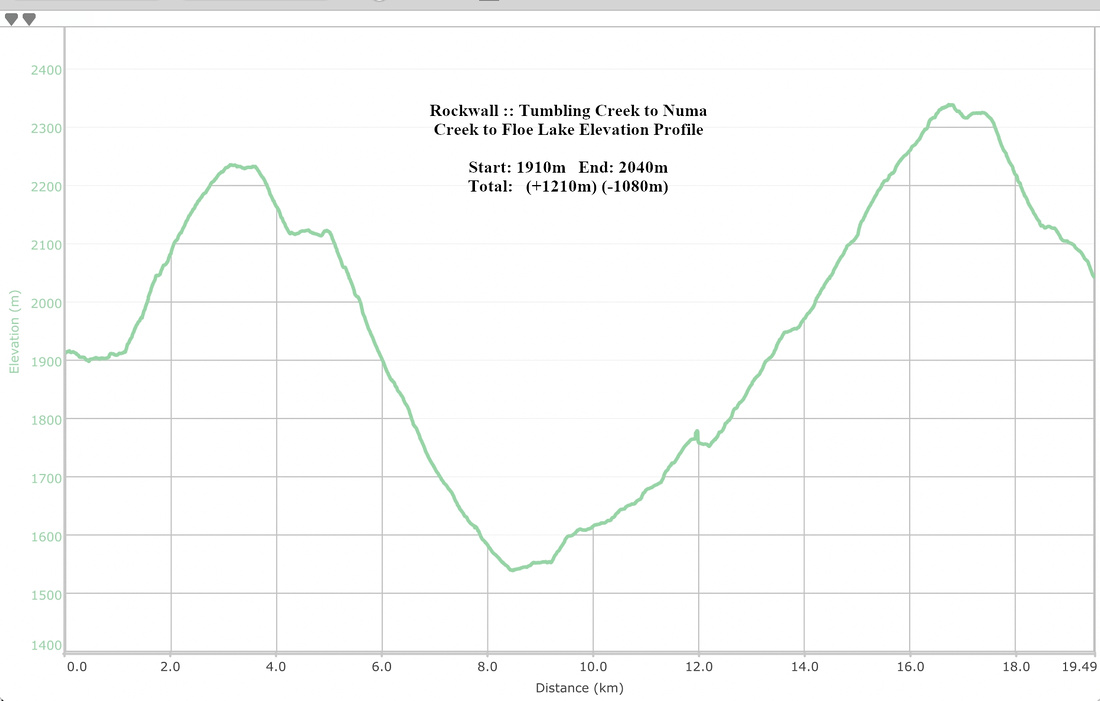 Tumbling Creek to Floe Lake Elevation
| Floe Lake to Hwy 93 | GPS Track | ||
|
Floe Creek trail provides south access to the Rockwall. It is considerably busier than Paint Pots - Helmet creek counterpart, as lots of people simply overnight at Floe Lake and come back the same way without hiking entire Rockwall trail. As result Floe Lake campground is the busiest and hardest to reserve spot in full summer season. It pays off to be persistent though, as it is one of most scenic official campgrounds in the Rockies. Often quoted as "de luxe" because of eating area on larch peninsula directly above the lake, with grand views of Rockwall cliffs on the other side! Bear awareness is often quoted paradigm when camping in back-country. As result Parks Canada have replaced many bear hangs with metal food lockers (all campsites on Rockwall included). But there is another wildlife risk lots of campers don't necessarily think about -- porcupines! Strange noise woke me up ~2am; I flashed the headlamp to see what was going on and almost jumped through the roof of my tent! Not more than 20cm away, separated from my head only by thin mesh of tent wall - a porcupine, feasting on my Keen sandals which I keep inside tent fly in case of bathroom break in the middle of the night. I banged and chased it away, but it came back forcing me to eventually get out and hang footwear on nearby tree. Morning inspection revealed totally chewed up and basically useless left sandal. So when you camp at Floe Lake beware, and make your boots/camp footwear inaccessible!
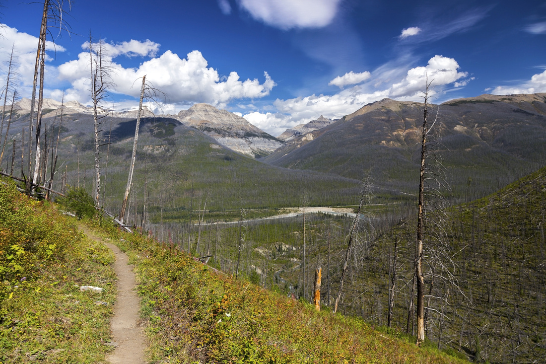
Hike itself back to Banff-Radium Highway is pleasant half-day trip. Switchback descent down timbered Floe Headwall (steep grunt if heading up this way!) is followed by long mainly flat sidehill traverse on south slope of Numa Mountain. Floe creek has been devastated by 2017 summer wildfires and trail is now largely in the open. Parks Canada predict it will soon become bear haven as it is getting overgrown and bears tend to feed on such bushy avalanche slopes. It is also waterless, so make sure you carry enough water as next reliable water source is not before bridged Floe Creek crossing near the trailhead. Final part makes long flat traverse south to bridge over Vermilion River; Floe trailhead is 400m away past this bridge. Your vehicle will hopefully be waiting for you here and you won't have to worry about hitching the ride back to Paint Pots where hike began on Day 1! |
|||
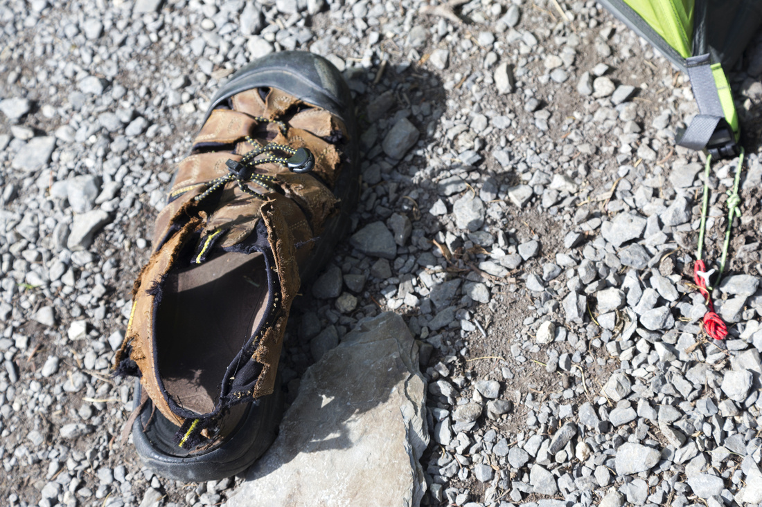 Chewed up Keen sandal - result of overnight Porcupine feast. Hang your footwear on tree, or keep inside the tent!
 |
|||
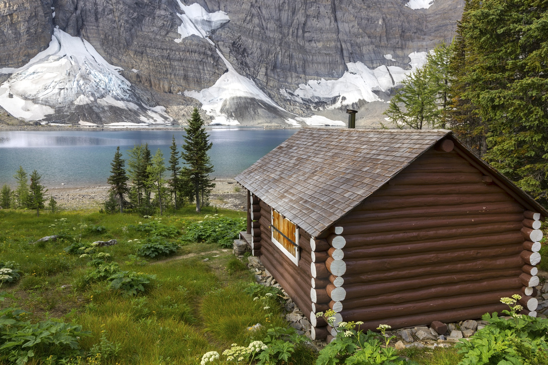 Floe Lake KNP Ranger Outpost - another simply awesome place for back-country cabin
 |
|||
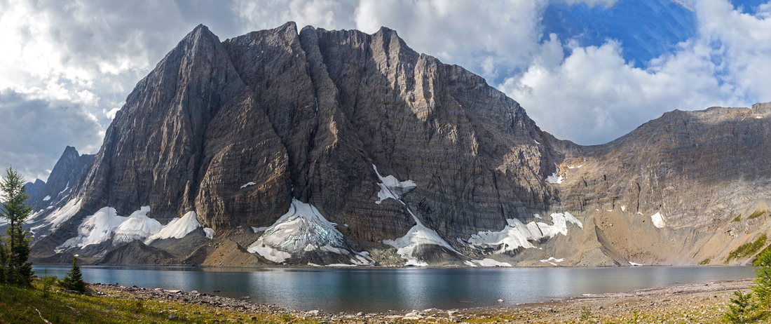 Panoramic View of Rockwall Cliffs above Floe Lake from beach below the campground
 |
|||
 View back to Floe Lake Headwall after steep switchbacking descent
 |
|||
 Open avalanche slopes that burned in widespread summer '17 wildfire, slowly getting overgrown again
 |
|||
 Trail nearing the end of long flat section and starting descent to Hwy93. Hawk Creek that provides access to Redearth Creek / Shadow Lake area and approach for Kane route up Mt. Isabelle center
 |
|||
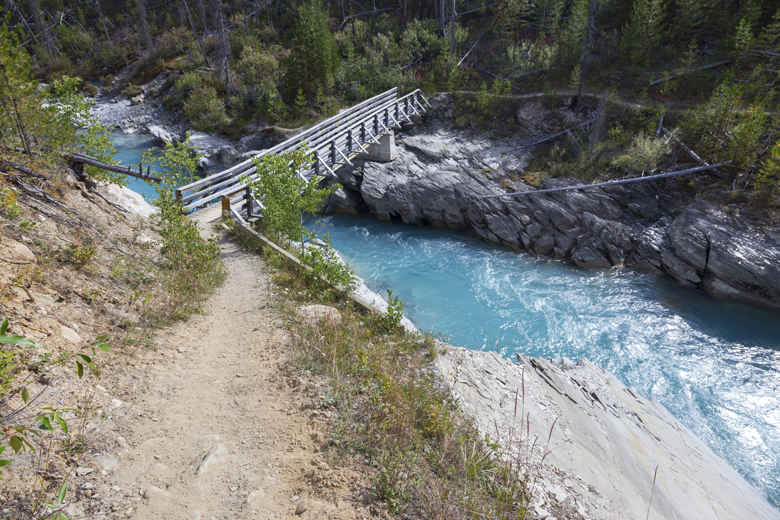 Vermilion River bridge near the trailhead, looking back
 |
|||
Abstract
| Overall Difficulty | D3 | Steep switchbacks on Floe Lake Headwall, mostly wide and flat trail afterwards. Bridged crossings of Floe Creek and Vermilion River near Trailhead | |||
| Snow Factor | S3/4 | Open avalanche slopes on north side of Floe Creek | |||
| Scenery | Floe Lake by the campground. Far reaching views on hike out via Floe Creek trail | ||||
| Trail/Marking | Excellent | Official park maintained trail with bridged creek crossings and marked junctions | |||
| Suggested Time | 3 hrs | Easy to moderate pace with overnight backpack. Add at least an hour if hiking the opposite way, because of steep Floe Headwall below the lake | |||
| Elevation | Start: 2040m End: 1350m Total: (+170m)(-810m) | Distance: 11 km | |||
| Gear | Full Hiking boots and Overnight gear. Light hikers would suffice for summer day-hike | ||||
| Water | Seasonal drainages but no reliable water source between Floe Lake and Floe Creek bridge near the trailhead. Carry 1-2L | ||||
| Dog Friendly | Yes | Please keep dogs under control as this is prime grizzly bear country and for consideration to other hikers | |||
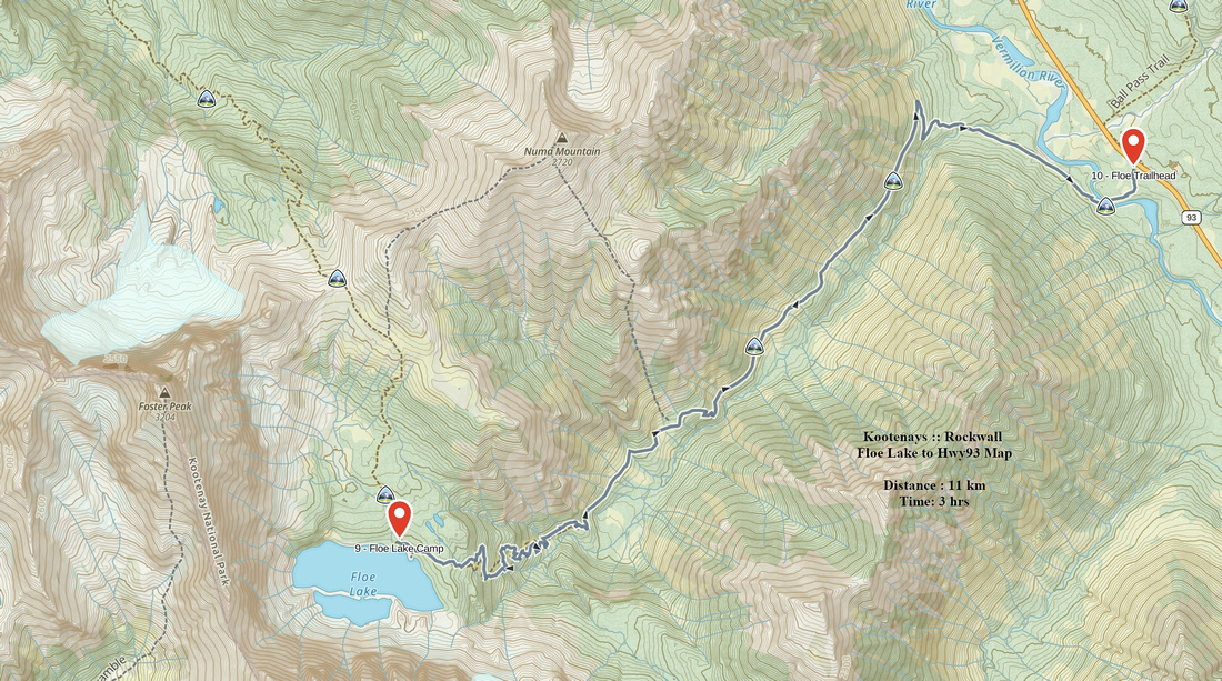 Floe Lake to Hwy93 GAIA Map
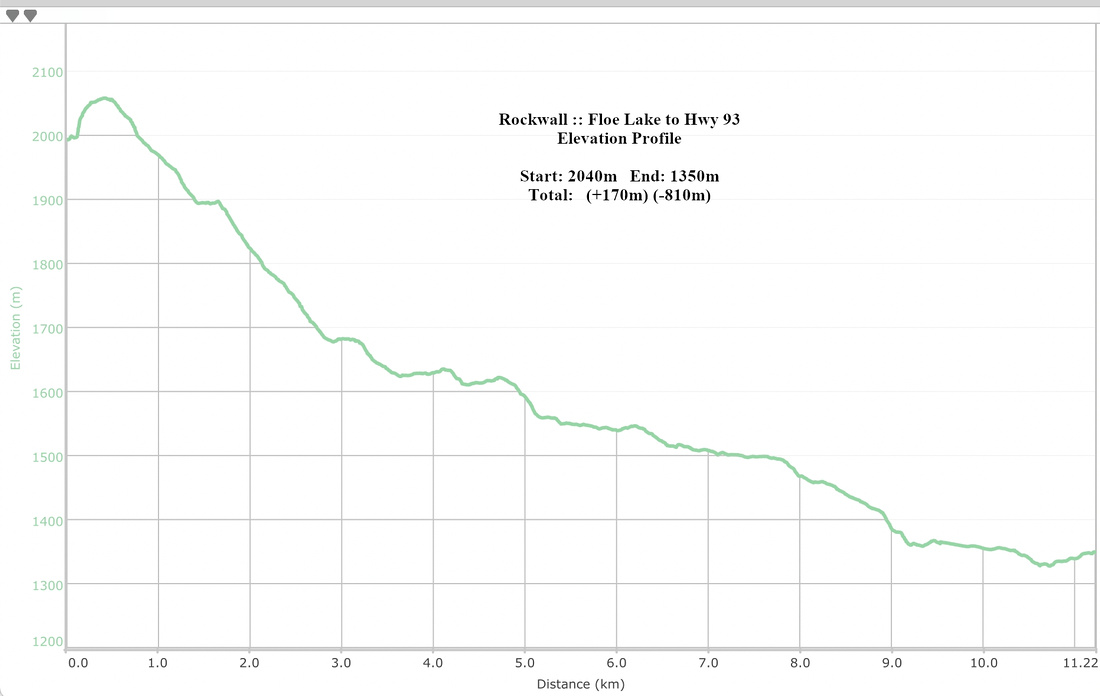 Floe Lake to Hwy 93 Elevation