Google Map |
Rockies :: Icefields :: Observation Peak |
GPS Track |
|
Panoramic view NE from Observation summit towards Siffleur wilderness. Isabelle Lake just right of center in the valley traversed on classic Dolomite circuit backpack. Foreground cornice likely never melts completely |
|||
| Trip Summary | |||
August 1, 2024Prominent Peak well above 3000m, directly above Bow Summit east side on Icefields Parkway. Catchy name comes thanks to fabulous 360 Panorama from ridge between lower and main Summits. Price for obtaining such viewpoint is over 1000m vertical of slogging up typical Rockies Talus. Negotiating Peeling Cliff band in upper part includes brief hands-on up low class 3 Chimney, but is not difficult. Kane effect over the years created fairly well defined trail with cairns throughout that makes micro-terrain route-finding easy. Despite this unprepared weekend social media hordes have frequently gone off-route, and even posted online YouTube videos that lure more folks the wrong way - I am quite surprised there are still relatively few accidents.
Parking area is directly opposite popular Peyto Lake access on Bow Summit. This is actually old exploration road, but can not be driven because of bushy stream crossing almost immediately. There are 2 drainage gullies below the peak (1st photo in Gallery). Correct gully is left (north); walk the road for ~10min max and watch for trail marked by cairn (Waypoint "1 - Turnoff", GPS Track download Top of Page). Forest trail with some deadfall leads to base of the drainage, then ascends on climber right side. It appears Left side might offer reasonable route, but it ends in a dropoff that requires technical downclimb - stay on the right side. After scrambling through the cliffband, tedious and loose scree leads to lower summit. Easy brief descent (trail) followed by shale plateau traverse leads to true summit in another 20-25minutes. Be mindful of east side cornice that likely never melts completely; fall through would likely be fatal.
Return is the same way, but before descent it is well worth briefly exploring Highline ridge between 2 summits (incorrectly labelled as Observation Peak on GAIA maps as of Aug '24). Views are spectacular and grant bird eye view of corridor traversed on classic Dolomite Circuit backpack as well as endless Sea of eastern BNP Peaks. |

|
Gallery |
|||
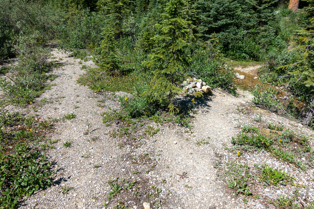
 Bow Summit Parking Bow Summit Parking Parking area on Bow summit east side, just opposite Peyto Lake tourist access road. Observation Peak lower summit just right of upper center; true summit left
 |
|||
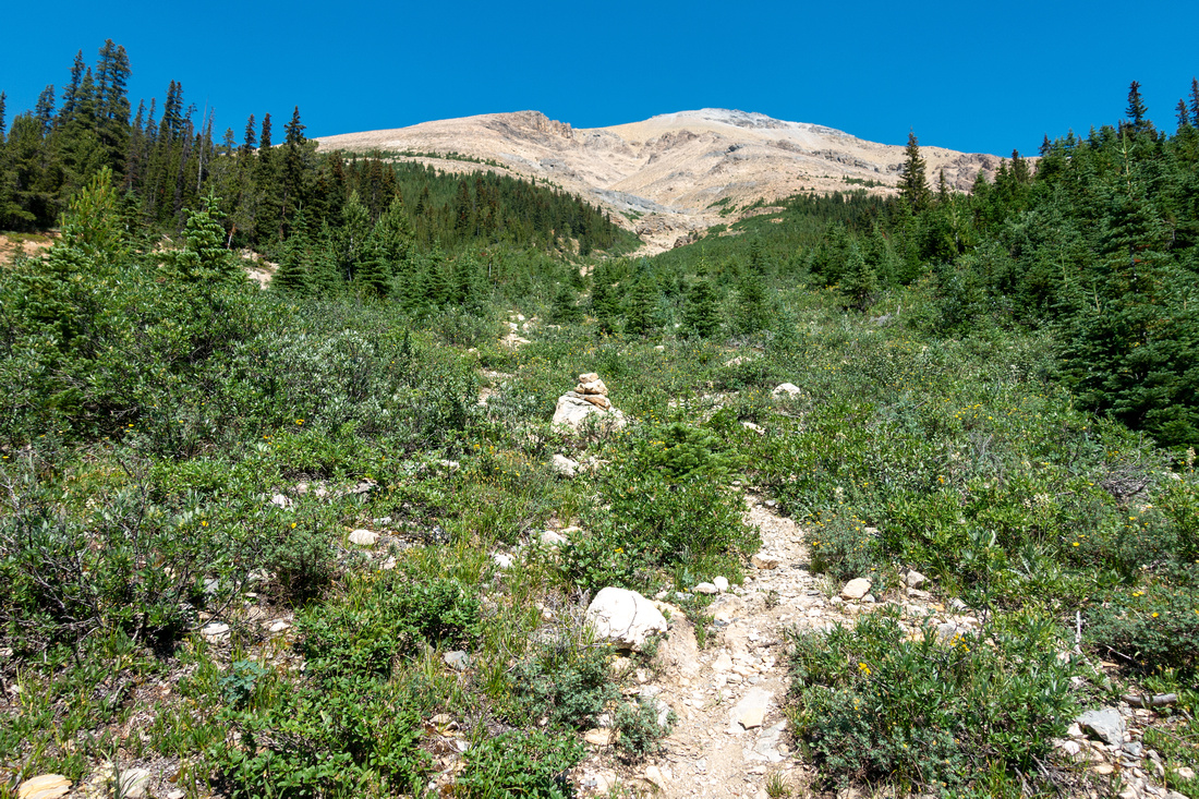
 Observation Turnoff
Standard Kane access to Observation north drainage (cairn) ~10min walk from Parking area. Seasonal creek is likely the only water source Observation Turnoff
Standard Kane access to Observation north drainage (cairn) ~10min walk from Parking area. Seasonal creek is likely the only water source |
|||
 Drainage Gully
Bottom of north drainage gully 10-15min from old road; note foreground Cairn. At top of last green patch Trail follows rib climber right. Do NOT climb left side as it leads to technical drop-off Drainage Gully
Bottom of north drainage gully 10-15min from old road; note foreground Cairn. At top of last green patch Trail follows rib climber right. Do NOT climb left side as it leads to technical drop-off |
|||
 Bow Summit Panorama
Spectacular views back are good reason for frequent stops. Bow Lake extreme left, Peyto Lake right of center; Jimmy Simpson in between Bow Summit Panorama
Spectacular views back are good reason for frequent stops. Bow Lake extreme left, Peyto Lake right of center; Jimmy Simpson in between |
|||
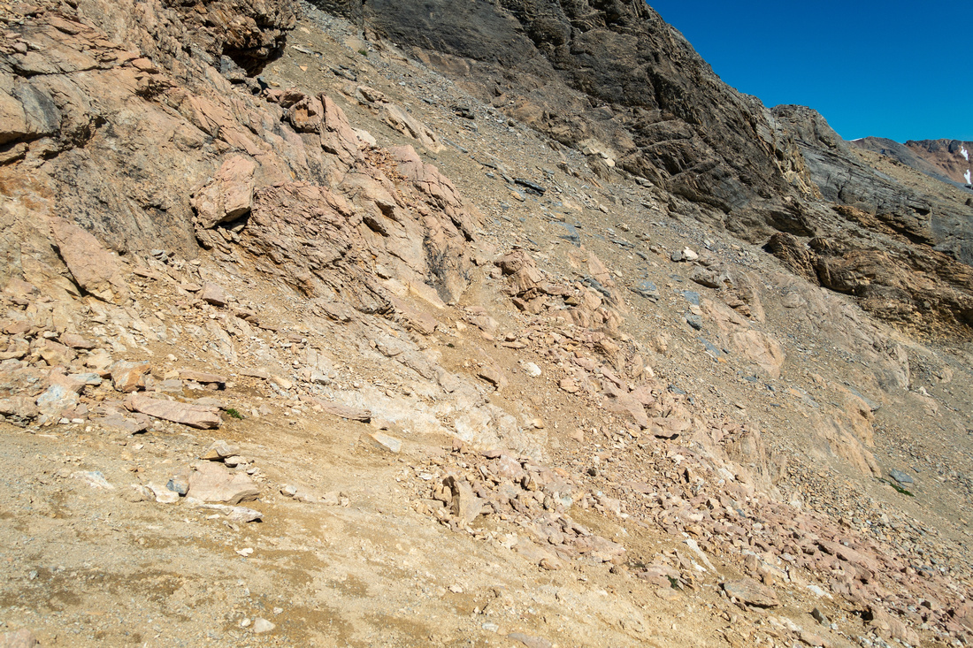
 Cliffs Route
Red Line indicating easiest route through peeling cliffs in the upper part. Crux is low class 3 Chimney, photo center Cliffs Route
Red Line indicating easiest route through peeling cliffs in the upper part. Crux is low class 3 Chimney, photo center |
|||
 Crux Chimney
Base of Crux Chimney - much easier from what this photo might suggest, but care is required on descent. Skyline notch exit is bit awkward Crux Chimney
Base of Crux Chimney - much easier from what this photo might suggest, but care is required on descent. Skyline notch exit is bit awkward |
|||
 Above the Chimney
 next set of cliffs is bypassed on climber right (steep, cairns) Above the Chimney
Above the Chimney next set of cliffs is bypassed on climber right (steep, cairns) |
|||
 Above the Cliffs
View back after scrambling through upper Cliffs. Horribly lose south gully route - to be avoided at all costs, even on return - joins here Above the Cliffs
View back after scrambling through upper Cliffs. Horribly lose south gully route - to be avoided at all costs, even on return - joins here |
|||
 Loose Talus
Steep and Loose Talus slopes above the Cliffs leading to lower Observation Summit Loose Talus
Steep and Loose Talus slopes above the Cliffs leading to lower Observation Summit |
|||
 North Nub
Prominent Rock Nub at North side - steep drop is best illustration why climbing left side of access drainage doesn't work North Nub
Prominent Rock Nub at North side - steep drop is best illustration why climbing left side of access drainage doesn't work |
|||
 Talus Slope
View down monster Talus slope; tedious going up, but fast on descent. Note two drainage gullies; correct one is right Talus Slope
View down monster Talus slope; tedious going up, but fast on descent. Note two drainage gullies; correct one is right |
|||
 Lower Summit
Final easy ridgewalk to lower Observation Peak Summit Lower Summit
Final easy ridgewalk to lower Observation Peak Summit |
|||
 Lower Summit Panorama
Southerly Panorama from lower Summit. Cirque Peak center right, Bow Lake extreme right Lower Summit Panorama
Southerly Panorama from lower Summit. Cirque Peak center right, Bow Lake extreme right |
|||

|
|||
 Observation Plateau
Descending to wide shale Plateau below lower summit. Observation Peak upper left Observation Plateau
Descending to wide shale Plateau below lower summit. Observation Peak upper left |
|||
 Lower Summit
View back to lower Summit; snow too early in season can make this part bit tricky Lower Summit
View back to lower Summit; snow too early in season can make this part bit tricky |
|||
 Observation Trail
Easy Trail beaten in soft shale leading to Observation true summit - pure joy to hike Observation Trail
Easy Trail beaten in soft shale leading to Observation true summit - pure joy to hike |
|||
 Shale Ridge
Looking back to lower Summit from shale Trail. Vast Wapta Icefield upper right corner Shale Ridge
Looking back to lower Summit from shale Trail. Vast Wapta Icefield upper right corner |
|||
 Summit Selfie
Posing by Observation Peak Summit Cairn; Register is usually tucked inside Summit Selfie
Posing by Observation Peak Summit Cairn; Register is usually tucked inside |
|||
 Observation Glacier
Glaciated north side of Observation Peak Observation Glacier
Glaciated north side of Observation Peak |
|||
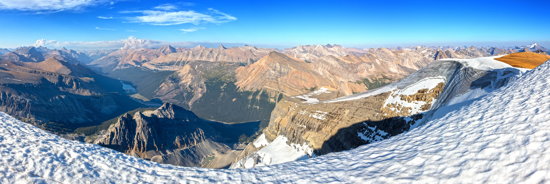 Siffleur Panorama
Sea of eastern BNP Peaks from Observation True Summit. Cloud smoke upper left from Nordegg area summer '24 wildfires Siffleur Panorama
Sea of eastern BNP Peaks from Observation True Summit. Cloud smoke upper left from Nordegg area summer '24 wildfires |
|||
 Wildfire Smoke
Nordegg Wildfire smoke Telephoto. Prominent peak center right is Mt. Recondite, one of 11,000'ers Wildfire Smoke
Nordegg Wildfire smoke Telephoto. Prominent peak center right is Mt. Recondite, one of 11,000'ers |
|||

|
|||
 Summit Cornice
Corniced Ridge seen by dropping a bit north from the Summit. Do not venture too close as fall would be deadly Summit Cornice
Corniced Ridge seen by dropping a bit north from the Summit. Do not venture too close as fall would be deadly |
|||
 Snow Hole
This shot probably illustrates best why walking on cornice is dangerous Snow Hole
This shot probably illustrates best why walking on cornice is dangerous |
|||
 Highline Return
Following Observation Ridge crest on alternate Highline return. Lower summit center right Highline Return
Following Observation Ridge crest on alternate Highline return. Lower summit center right |
|||
 Observation Glacier
Closer look at Glaciated Observation Peak south side Observation Glacier
Closer look at Glaciated Observation Peak south side |
|||
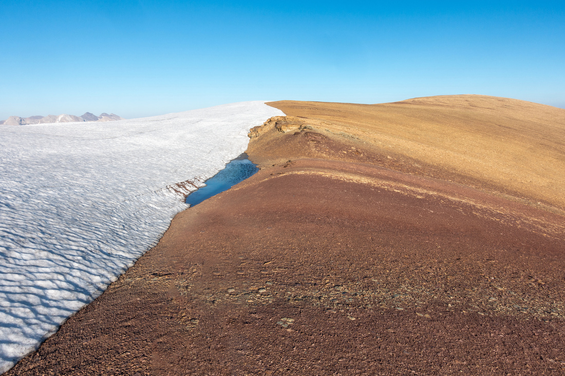 Melting Cornice
Small tarn forming at demarcation of snow cornice and reddish shale. After hiking up to Highpoint upper right, trash down to intersect the trail Melting Cornice
Small tarn forming at demarcation of snow cornice and reddish shale. After hiking up to Highpoint upper right, trash down to intersect the trail |
Abstract
|
Overall Difficulty |
Steep Talus, loose in upper part. Low class 3 Chimney. Considerable overall elevation gain. |
||||
|
Snow Factor |
Huge avalanche danger in steep Drainage Gully. Some people ski lower Observation slopes in winter |
||||
|
Scenery |
Bow and Peyto Lakes, Wapta Icefield. Siffleur Wilderness and Sea of eastern BNP Peaks |
||||
|
Trail/Marking |
Good |
Kane effect has resulted with fairly well defined trail and cairns if following normal route. Minor deadfall |
|||
|
Suggested Time |
8 hrs |
Moderate Pace with ~1hr Summit Break and exploring of Observation Ridge |
|||
|
Elevation |
Start: 2065 m Max: 3175m Total: ~1200m |
Round Trip: ~9km | |||
|
Gear |
Full hiking boots, gaiters and poles. Climbing helmet essential in group (rockfall danger). |
||||
|
Water |
Seasonal creek near start, snow patches above. Carry 3L min on a hot summer day |
||||
|
Dog Friendly |
Yes |
Care will be needed in Crux Chimney. Sharp rock throughout might be hard on paws |
|||
 Observation Peak GAIA MapGAIA Errors:
1) Misplaced summit location. Correct location is "4 - Observation Peak" as on my GPS (purple) track
2) Dark dotted GPS trace is wrong, uploaded to openstreetmap by people with bad routefinding skills. Correct line is Purple, that follows standard Kane route
Observation Peak GAIA MapGAIA Errors:
1) Misplaced summit location. Correct location is "4 - Observation Peak" as on my GPS (purple) track
2) Dark dotted GPS trace is wrong, uploaded to openstreetmap by people with bad routefinding skills. Correct line is Purple, that follows standard Kane route
 Observation Peak Elevation Profile