Google Map |
Rockies :: Canmore and Bow Valley :: Peechee Shoulder |
GPS Track |
|
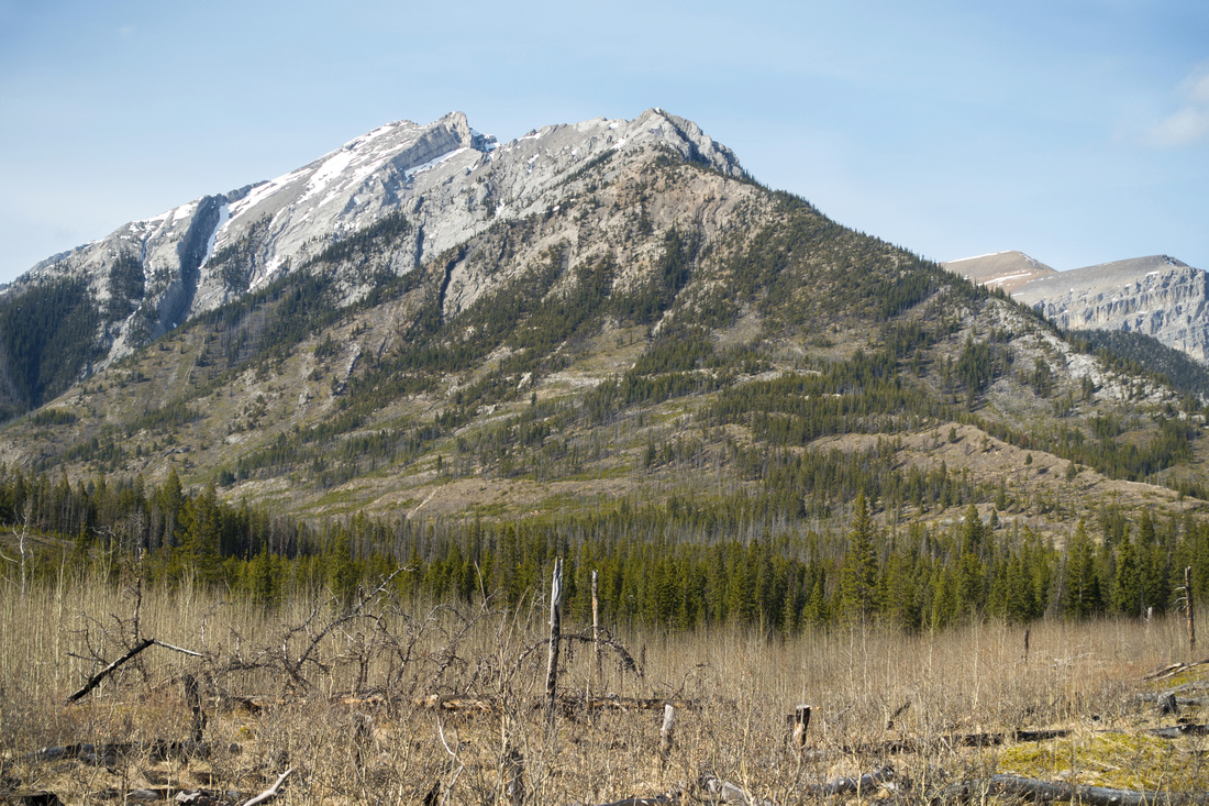
Mount Peechee from Carrot Meadows showing "Peechee Shoulder" ascent ridge; Main summit upper left |
|||
| Trip Summary | |||
May 5, 2021Mount Peechee, together with Mt. Inglismaldie and Mt. Girouard provides scenic backdrop of Aylmer Lookout / Minnewanka Lakeshore trail. White later two have well-documented scramble route, there is little info about Mt. Peechee. Only online info I found is at this local Canmore site; sunny south facing ridge rising west from Carrot Creek drainage provides reasonable way up. It does not connect all the way to the main summit, but views of Bow Valley are fantastic. With added remote/exploration feel it is great early or late season scramble. Trip is not for beginners, as there is fair amount of non-trivial route finding, coupled with Carrot Creek ford and final exposed rock scramble. Carrot Creek crossing is unavoidable so trip is not feasible during spring runoffs. With time (or energy!) constraints, it is well worth exploring at least the lower ridge for pleasant few hrs stroll in Fairholme area.
Parking is at north side of Trans-Canada, ~2km past BNP East gate. Unsigned road leads to parking area and fence; this was Carrot Creek trailhead for crossover to South Ghost Pass / Lake Minnewanka, but trip became very difficult and largely abandoned after spring 2013 spring runoffs. Initial walk across open meadows following old wagon trail could be cycled, but park sign by the gate at time of this writing (spring 2021) disallows that. Close the gate behind you, and walk for ~30min with great views around. Ascent ridge is to the left - see 3rd photo in gallery. Wagon trail eventually fades and transfers into single track descending towards Carrot creek. There is some deadfall here as trail is not maintained. Carrot creek is reached in ~3km from parking; note spot where trail emerges from the forest, to be able to pick it up on return. Small cairn was here on my trip; if you make use of GPS track, it is waypoint "1-Carrot Creek". From here trip is entirely off-trail.
Hop over the creek and ascend lower ridge, then look for suitable spot to transfer to Main ridge on right side. Resist urge to go too early as there is much deadfall in intervening valley lower down, but do not go too high as there are some cliffs peeling off & you might have to backtrack. Waypoints "2-Lower Ridge" and "3-Main Ridge" on GPS track are good choice. Reaching Main ridge turn left and go up; despite lack of trail going is fairly straightforward and, except for one short stretch, not too steep. View back to Princess Margaret and Charles Stewart are fantastic, as well as aerial panorama of long Carrot Creek canyon leading to South Ghost Pass. After about an hour of steady climb reach treeline and start of rock scramble. Buttress directly above is "Peechee Shoulder"; going further is entirely optional as views won't get much better. Going is initially easy but it gets progressively more difficult and reaches stiff 3rd/4th class higher up. Beyond is strictly technical territory and I could not find any info if someone actually climbed Mt. Peechee this way.
Return the same way. On descent you must cross back to lower ridge; resist urge to trash down to Carrot Creek via Main ridge or intervening valley.
|
|
Gallery |
|||
 Carrot Meadows Carrot Meadows Initial ~2.5km approach hike following old wagon trail; Princess Margaret right, Mount Peechee left, Carrot creek in between
 |
|||
 Bow Valley
Easterly view down Bow Valley with Canmore area peaks on Horizon. Bow Valley
Easterly view down Bow Valley with Canmore area peaks on Horizon. |
|||
 |
|||
 Carrot Creek
 crossing; easy when water is low, but might be impassable during spring runoffs Carrot Creek
Carrot Creek crossing; easy when water is low, but might be impassable during spring runoffs |
|||
 Lower Ridge
Small cairn on lower ridge, important to identify on return for easiest trash down to Carrot Creek Lower Ridge
Small cairn on lower ridge, important to identify on return for easiest trash down to Carrot Creek |
|||
 |
|||
 Charles and Margaret
Charles Stewart (L) and Princess Margaret (R) from main ridge Charles and Margaret
Charles Stewart (L) and Princess Margaret (R) from main ridge |
|||
 South Ghost Pass
 and Carrot Peak Telephoto South Ghost Pass
South Ghost Pass and Carrot Peak Telephoto |
|||
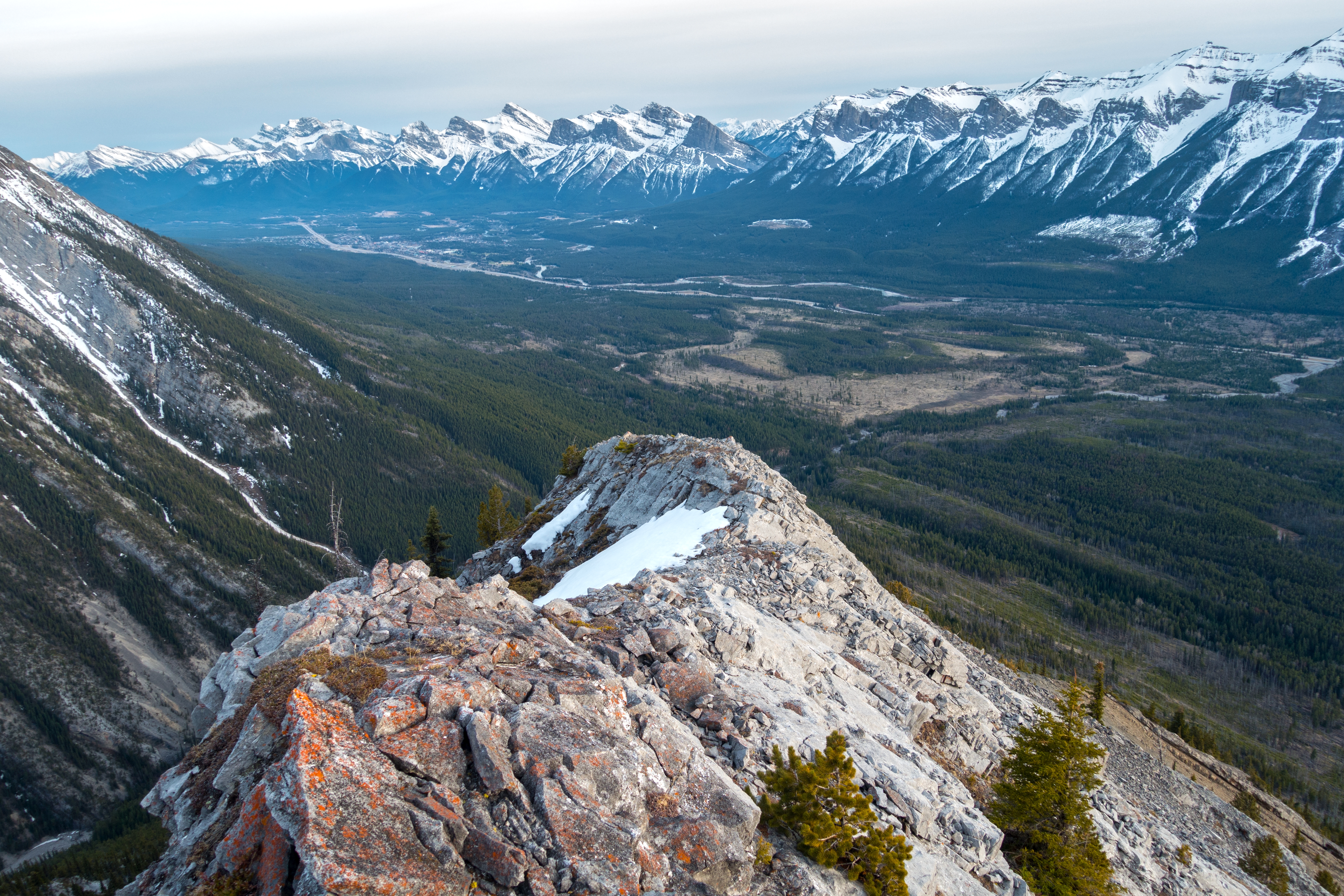
 Peechee Shoulder
Scramble leading to prominent buttress (center); you scramble on moderately exposed ridge crest most of the way, and it gets progressively more difficult (class 3/4) the higher you go; must be dry Peechee Shoulder
Scramble leading to prominent buttress (center); you scramble on moderately exposed ridge crest most of the way, and it gets progressively more difficult (class 3/4) the higher you go; must be dry |
|||
 Peechee Shoulder
Final part; takes no more than 10 min. It is perfectly acceptable to turn back here, as views won't get better Peechee Shoulder
Final part; takes no more than 10 min. It is perfectly acceptable to turn back here, as views won't get better |
|||
 |
|||
 Bow Valley
 panorama; Banff area to the right. Small body of water far center right is Johnson Lake Bow Valley
Bow Valley panorama; Banff area to the right. Small body of water far center right is Johnson Lake |
Abstract
| Overall Difficulty | D5 | Unbridged creek crossings, route-finding with deadfall and exposed rock ridge scrambling | |||
| Snow Factor | S2 | Sunny north side of Bow Valley means dry conditions in early-mid spring. Low avi danger in winter | |||
| Scenery | Great approach hike on open montane meadow. Panoramic view of Bow Valley, Rundle range/Canmore area peaks and deep into Carrot Creek drainage. Fairholme Range, Charless Stewart and Princess Margaret. | ||||
| Trail/Marking | None | Faint trail with some flagging to Carrot Creek only with occasional cairns | |||
| Suggested Time | 5-6 hr | Return time if going all the way to end on main ridge. 3hr if exploring only lower ridge | |||
| Elevation | Start: 1420m Max: 2250m Total: ~900m | Round Trip: ~12km | |||
| Gear | Hiking boots, poles and gaiters. GPS recommended | ||||
| Water | Carrot Creek, none after. Carry ~1.5L | ||||
| Dog Friendly | Yes | Standard back-country trip precautions. Final part of main ridge likely not feasible for dogs | |||
 Peechee Shoulder GAIA Map
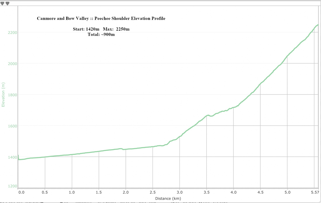 Peechee Shoulder Elevation Profile