Google Map |
Rockies :: Canmore and Bow Valley ::Cloudline |
GPS Track |
 
Brand spanking new Alberta Parks bench at Cloudline Crest |
|||
| Trip Summary | |||
July 20, 2023
Cloudline is mainly MTB Trail. Officially opened in summer of '23, it is eastern continuation of well-known Highline traversing lower slopes of Little Sister between Three Sisters and Stewart Creeks. West access is Hubman Landing at top of Three Sisters Boulevard, while east terminus is Stewart Creek Hiking trail; it naturally leads itself to a loop. Hikers are allowed and I decided to check it out of curiosity. For a cycling trail I thought it was quite challenging as there are some steep parts, tight switchbacks and narrow sections on top of small bluffs. Although net elevation gain is just over 200m, GPS recorded over 500m cummulative due to all small ups/downs. Most of the way is forested allowing just peek-a-boo glimpses of Bow Valley north side.
From Hubman landing I followed marked Highline to Three Sisters Creek crossing, then turned up the creek by signed junction. Only minor difficulty - from hikers perspective - is unbridged creek crossing bit further up by small Dam. (It is worth checking small waterfall 5-10 min up the creek). Cloudline then ascends fairly steeply on the other side, eventually cresting by wonderful wooden bench (lead photo). Flat section is followed by gradual descent to Stewart Creek, crossing Fall creek along the way (water) and joining usual Middle Sister access. Being familiar with area I simply trashed down to Golf Course then took most direct shortcut back to Hubman via (ever growing) residential area, as reflected on GPS track; cyclists will probably follow Stewart Creek Trail down to Three Sisters Parkway then cycle back on the road. If starting from east side I've heard Guy Lefleur Trailhead is also used, but I haven't checked it out.
Cloudline will mostly appeal to mountain cyclists and possibly trail runners. Coming from Calgary on weekend for this trail is probably not best use of time, but for locals it provides good few hours of exercise. It can also be used as Little Sister approach, although it does not totally eliminate all the lower part bushwhack.
|
|
Gallery |
|||
 Hubman Landing
Looking back to Hubman Landing at East End of Highline. Street Parking is usually easy to find Hubman Landing
Looking back to Hubman Landing at East End of Highline. Street Parking is usually easy to find |
|||
 Highline Trail
 reaching Three Sisters Creek ~20min past Hubman Highline Trail
Highline Trail reaching Three Sisters Creek ~20min past Hubman |
|||
 Three Sisters Creek
Bridged Crossing of Three Sisters Creek; picnic table is on the other side, upper right Three Sisters Creek
Bridged Crossing of Three Sisters Creek; picnic table is on the other side, upper right |
|||
|
|
|||
 Three Sisters Creek Ford
Three Sisters creek crossing just downstream of old Dam; Cloudline sign on the other side Three Sisters Creek Ford
Three Sisters creek crossing just downstream of old Dam; Cloudline sign on the other side |
|||
 Three Sisters Creek
 as Cloudline turns left and up the Forest. For hikers it is worth hiking a bit up the creek to small waterfall Three Sisters Creek
Three Sisters Creek as Cloudline turns left and up the Forest. For hikers it is worth hiking a bit up the creek to small waterfall |
|||
 Three Sisters Waterfall
Three Sisters Creek Waterfal, side trip ~5min past Cloudline; rough trail continues above the Falls to Three Sisters Pass Three Sisters Waterfall
Three Sisters Creek Waterfal, side trip ~5min past Cloudline; rough trail continues above the Falls to Three Sisters Pass |
|||
 Grotto Peek-a-boo
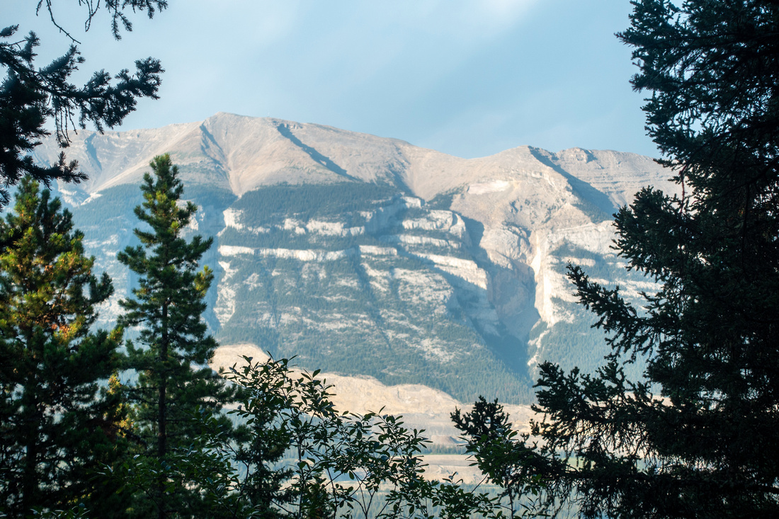
Limited views through trees of Grotto Mountain on Bow Valley North Side Grotto Peek-a-boo
Limited views through trees of Grotto Mountain on Bow Valley North Side |
|||
 Cloudline Trail
Typical Cloudline section on east side Cloudline Trail
Typical Cloudline section on east side |
|||
 Warning Sign
Cyclist Warning signs before descending steep parts Warning Sign
Cyclist Warning signs before descending steep parts |
|||
 Fall Creek
Bridged Fall Creek crossing (note another bench on the other side) Fall Creek
Bridged Fall Creek crossing (note another bench on the other side) |
|||
 Stewart Creek
 Dam crossing and Cloudline east terminus Stewart Creek
Stewart Creek Dam crossing and Cloudline east terminus |

Abstract
| Overall Difficulty | D2 | Moderate angled forest hiking with couple of steeper sections. One non-bridged creek crossing | |||
| Snow Factor | S1 | Forested trail with no avalanche danger, but portions might be icy in winter | |||
| Scenery | Three Sisters and Stewart Creeks; Peek-a-boo views through tree cover | ||||
| Trail/Marking | Excellent | Well defined trail with signed junctions | |||
| Suggested Time | 3 hrs | Hiking time for full loop. Cycling will be faster | |||
| Elevation | Start: 1380m Max: 1600 m Total: ~530 m | Round Trip: ~10 km (Golf Course Shortcut) | |||
| Gear | Light hikers are sufficient | ||||
| Water | Three Sisters and Stewart Creeks; Fall creek. No need to carry more than 0.5L | ||||
| Dog Friendly | Yes | Beware cyclists and keep dog on leash | |||
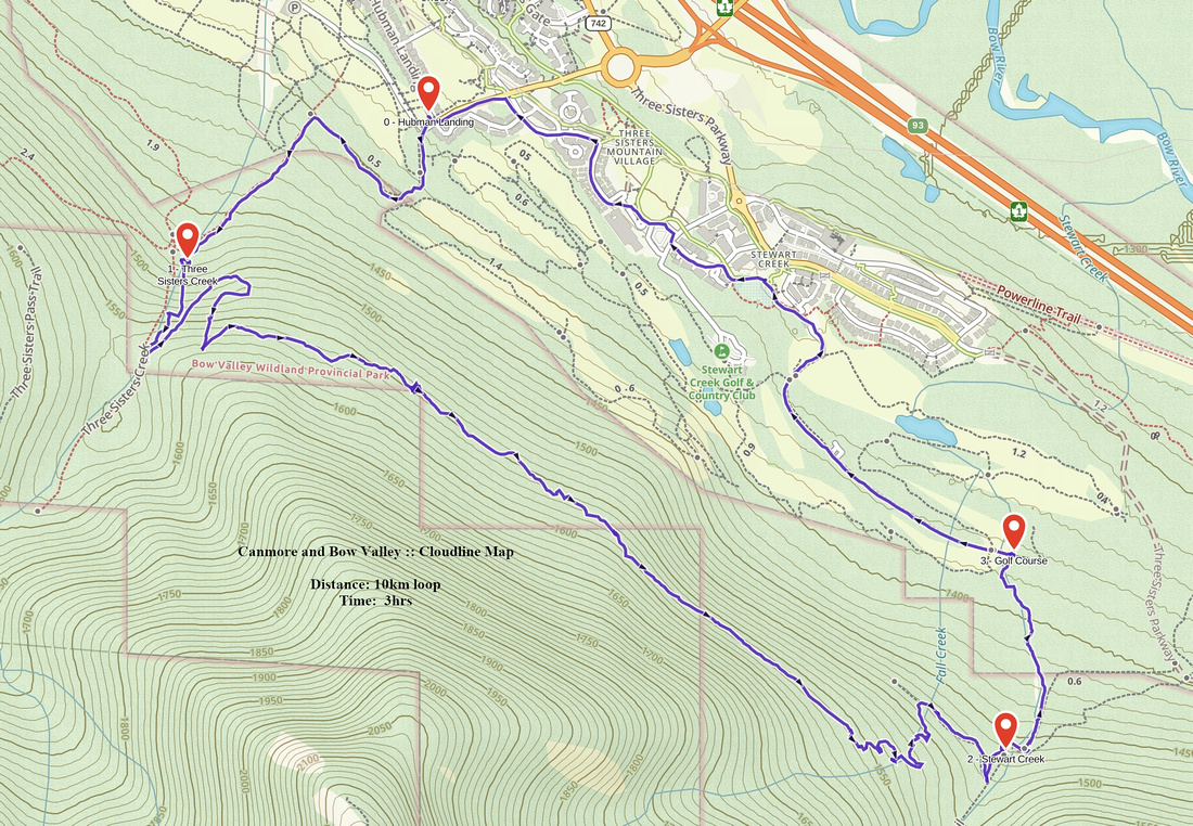 Cloudline GAIA Map
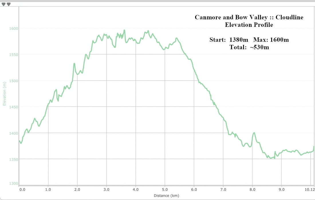 Cloudline Elevation Profile