Google Map |
Rockies :: Banff-Louise :: Tessa Falls |
GPS Track |
 
Rarely visited Tessa Falls from north side of Cascade River |
|||
| Trip Summary | |||
Dec 23, 2024
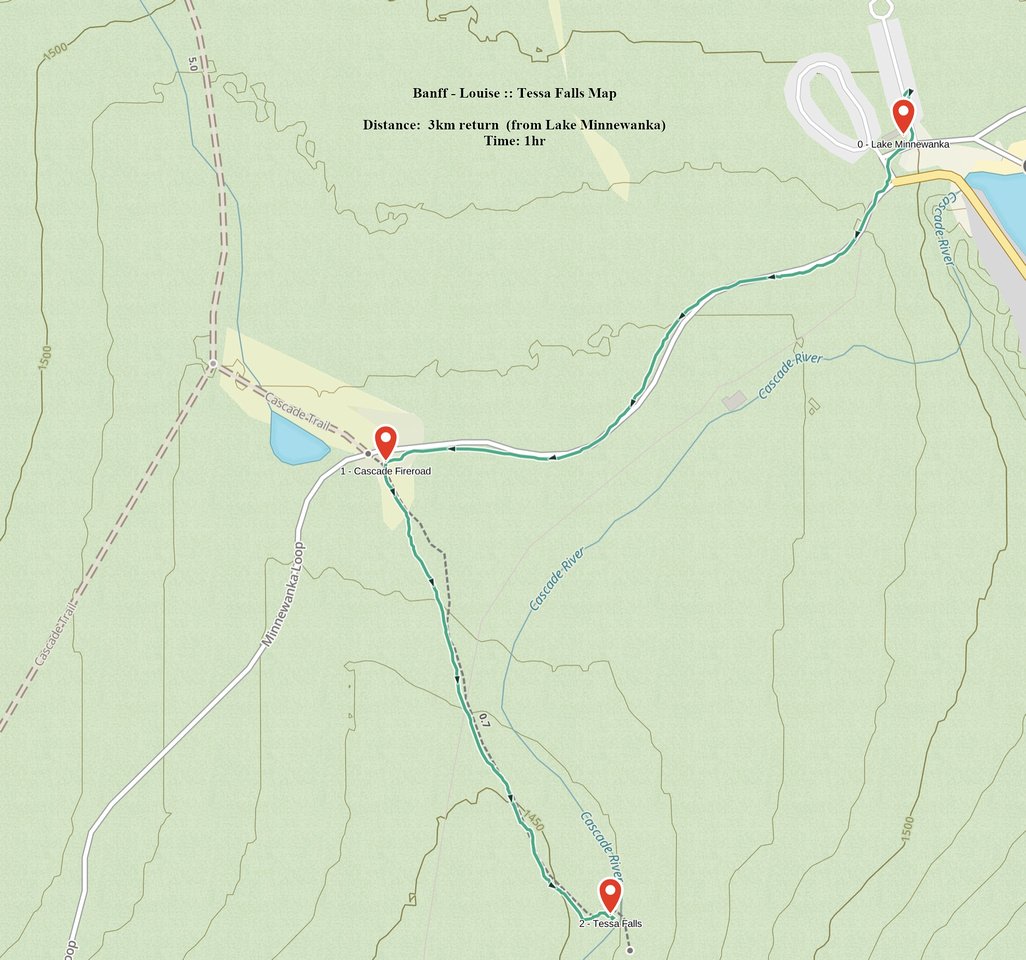
Tessa Falls are totally off-radar Cascade River chutes in Lake Minnewanka proximity. Living in Bow Valley I've been in the area countless times, but learned about Tessa only in Dec '24. Hike is very short, even in winter when gated Minnewanka Scenic road adds ~1km (each way). Trailhead is not marked; it will be at roadside pullout ~15min from Minnewanka Main parking lot (Waypoint '1 - Cascade Fireroad', GPS Download Top of Page). In summer it is currently possible to park here as well.
Unsigned but reasonably well defined trail undulates semi-open forest for 10min or so, ending at top of Cascade River embankment. This is 'crux' - so to speak - as descent, although brief, is very steep and awkward, specially if icy (micro-spikes). Tessa Falls are on the other side (see Gallery). Area is boggy but if you trash a bit downstream there are usually some logs that could be used to cross to the other side - if dry. On my December trip it was quite slippery so I satisfied myself by taking couple of telephotos before returning the same way.
In summer Tessa can be combined with some other Minnewanka Road hike - C Level Cirque for instance - for satisfying half day in Banff Vicinity. |
|
Gallery |
|||
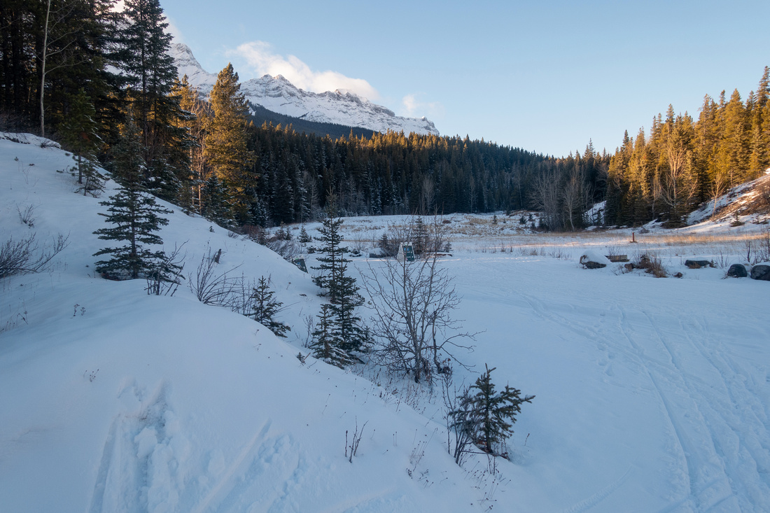
 Minnewanka Road Minnewanka Road Hiking down Minnewanka Road, closed in Winter and track set by XC skiers. Mt. Cascade in the Background
 |
|||
 Tessa Trailhead Tessa Trailhead Tessa Falls trail starts at pullout ~1km below main Minnewanka Parking area. In summer when road is open one could park right here. Cascade Fireroad Meadows in the distance
 |
|||
|
|
|||
 Steep Embankment Steep Embankment Very steep Cascade River embankment at end of approach trail - much steeper from what this photo might suggest. Hiking poles are asset and micro-spikes might be necessary in winter
 |
|||
 Tessa Falls Tessa Falls Tessa Falls - just a trickle in December - from north side of Cascade River
 |
|||
 Tessa Falls Tessa Falls Alternate shot of Tessa. Couple of logs span the river and in summer it is feasible to cross over to the other side for a closer look
 |
Abstract
| Overall Difficulty | D1/2 | Short and easy forested walk ending with steep and awkward descent to Cascade River | |||
| Snow Factor | S1 | No issues until Cascade River embankment which can be tricky if icy | |||
| Scenery | Minnewanka Environs, Cascade Mountain and Tessa Falls / Gorge | ||||
| Trail/Marking | Fair / None | Unmarked but reasonably well defined forest trail | |||
| Suggested Time | 1 hr | If starting from Lake Minnewanka parking in winter; less in summer from Cascade Fireroad Pullout | |||
| Elevation |
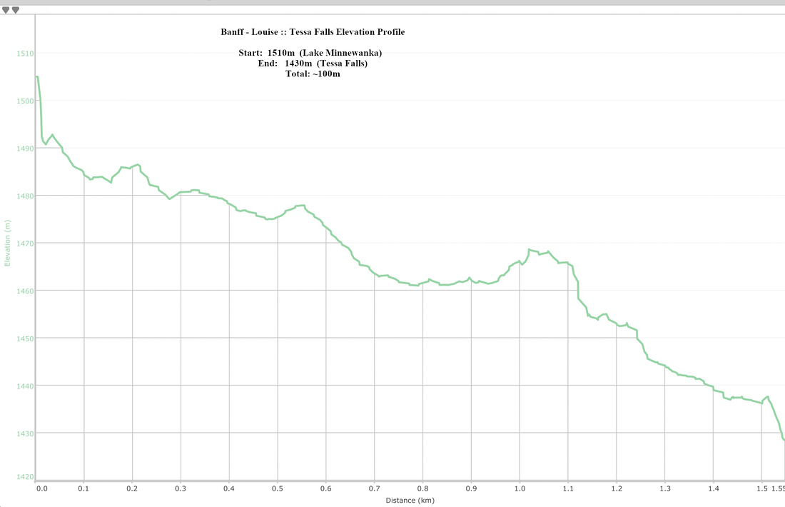
Start: 1510m End: 1430m Total: ~100m (From Lake Minnewanka) |
Round Trip: ~3km (from Lake Minnewanka) |
|||
| Gear | Running shoes or day hikers. Hiking poles, Micro-spikes helpfull for icy Cascade Embankment in Winter | ||||
| Water | Very short trip; water can be had at Cascade River if necessary | ||||
| Dog Friendly | Yes | Standard back-country precautions | |||
 Tessa Falls GAIA Map
 Tessa Falls Elevation Profile
