Google Map |
Rockies :: Alberta Foothills :: Forgetmenot Ridge |
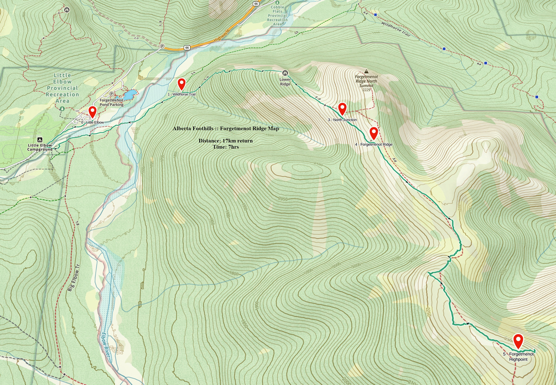
GPS Track |
 
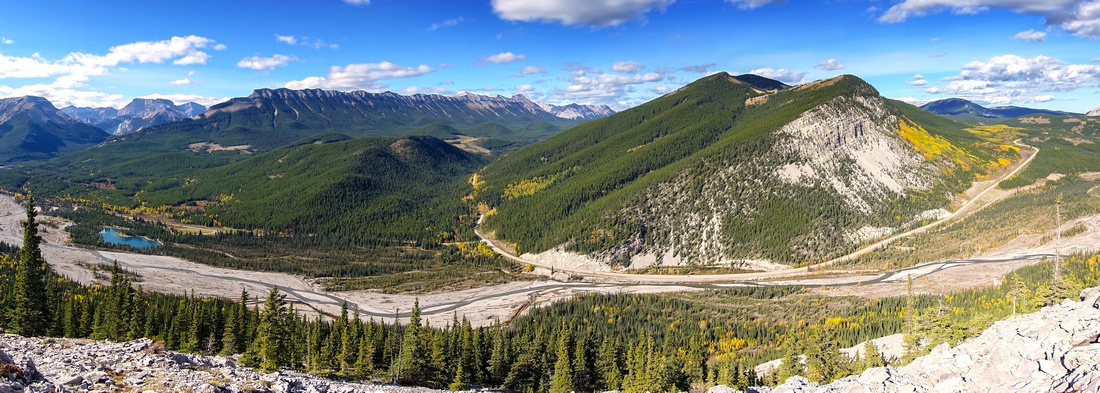
Central part of Forgemenot Ridge from top of Rocky Knoll. North Summit just left of center with Powderface Ridge behind. Nihahi far left |
|||
| Trip Summary | |||
Multiple Dates, last Oct 3, 2024Forgetmenot is one of classic Foothills Ridgewalks. Rounded grassy crest extends for many km offering great views of Front Ranges and Prairies. Price to pay is stiff ascent on steep-ish and eroded trail. Best done in the Fall when water level have subsided and Prairie Grassland Autumn colours are abundant. Most common option is out-and-back hike to Ridge Highpoint (also known as "Old Forgetmenot"), which is how Report and Gallery are presented. Long Day extension is visit to Forgetmenot Mountain including Threepoint Creek / Big Elbow loop return. As always with Little Elbow area Trails be aware that Hwy66 is seasonally closed Dec 1 - May 14 past Elbow Falls gate.
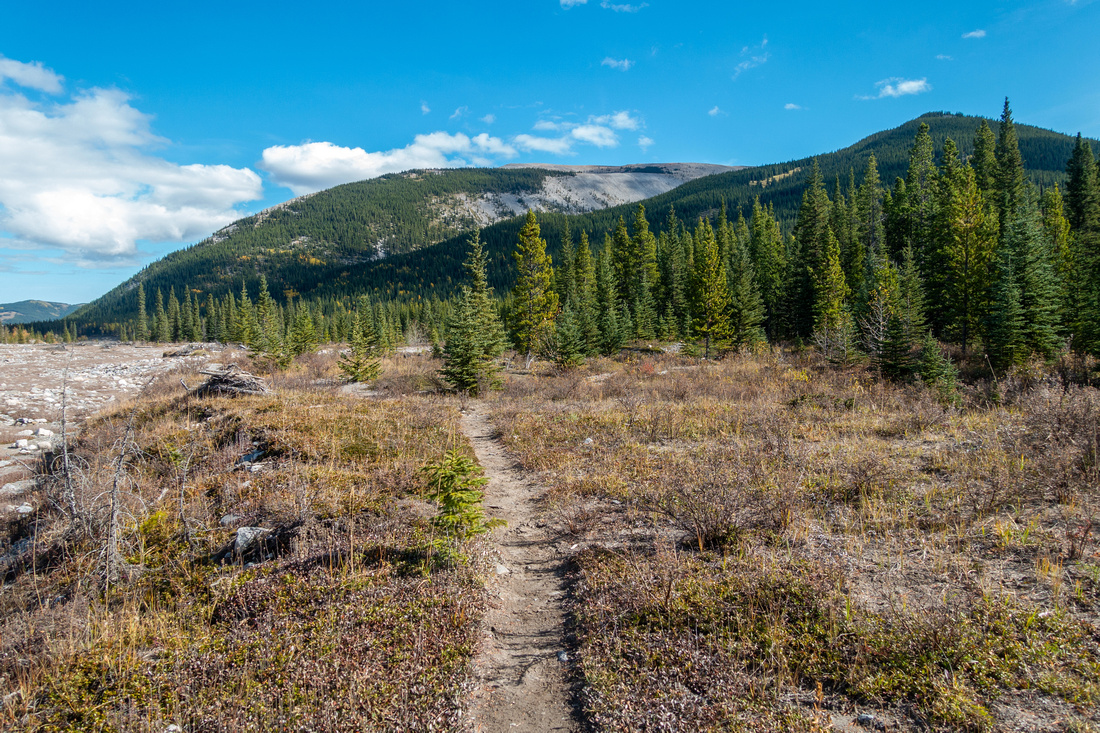
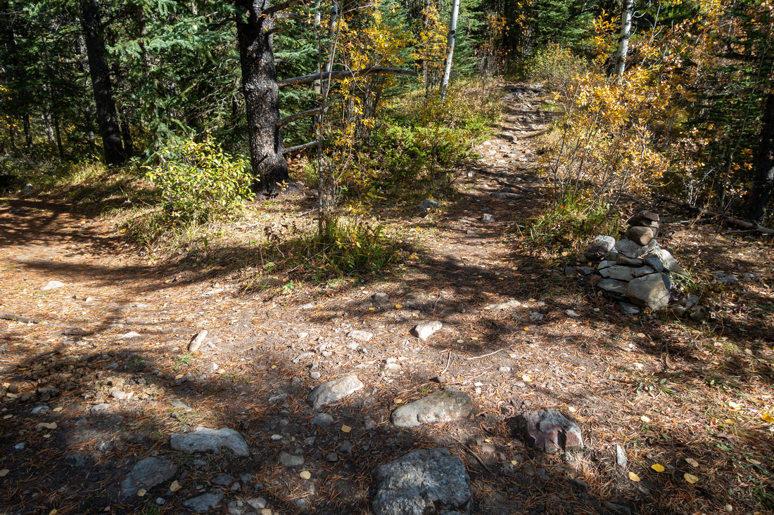
There are no navigation issues, except at very start as you must cross Little Elbow River then follow Wildhorse hiking/equestrian trail across River Flats and Forest to signed Junction. Walking north to Harold Chapman suspension bridge is what most people end up doing, but that does add at least 1km - each way. Alternative is Little Elbow Ford right below the Parking Lot; bring pair of old Sandals if this option is appealing. Regardless of approach tactics, Forgetmenot Trail forks off by Cairn - see Gallery, Waypoint "1 - Wildhorse Trail", GPS Download Top of Page). Ascent is steep and lower part of trail is fairly eroded - hiking poles are great help, specially on descent. Higher above grade moderates and after some wide Talus switchbacks views really open up. Lower Ridge is semi-forested and pure joy to hike. Continue past North Summit junction and hike up scree to grassy ridgeline when trail vanishes by cairn. Note this spot for return; good landmark is short pine tree that also had green flag on my Oct '24 visit - see Gallery.
Hiking grassy ridge towards Old Forgetmenot is super scenic, specially on a clear windless day. Only slight challenge is Rocky Knoll ~30min in; briefly descend on grass then pick-up good trail that develops on left (east) side. Remainder to the Highpoint is most enjoyable part of the day, but you must also cross green lichen rock field; footing is stable, but you can not completely zoom out, specially if wet. From the Highpoint I walked for couple of minutes to east end that also had wind shelter; this is the turnaround point. On return with enough time and energy, hike to North End will be pleasant way to finish the day. Forgetmenot MountainI did this extension long time ago when website authoring and methodical documenting of outdoor pursuits was still not an interest of mine. From memory it will take about an hour from Old Forgetmenot (1-way), involving descent to low saddle and loss of over 100m vertical that needs to be regained on other side. Views will not be better, but will provide different perspective of Threepoint Mountain. It is best to return the same way, but if interested in loop here is what to expect: From Forgetmenot "Mountain" I picked up trail descending south slopes to Threepoint Creek valley, then hiked along the creek eventually ending at confluence and mandatory Big Elbow Ford. This is the crux as you must evaluate water levels beforehand and be sure Ford will be feasible Loop ends with tedious walk on Big Elbow Trail for at least an hour to Harold Chapman bridge and back to Parking. Allow 8-10 hrs for Full Loop, depending on pace.
|
|
Gallery |
|||
 Little Elbow
Forgetmenot Ridge from Little Elbow Trailhead Parking. Unless willing to ford, you must walk to Harold Chapman Suspension bridge (~1km south) Little Elbow
Forgetmenot Ridge from Little Elbow Trailhead Parking. Unless willing to ford, you must walk to Harold Chapman Suspension bridge (~1km south) |
|||
 Harold Chapman Bridge Harold Chapman Bridge
Harold Chapman Suspension Bridge ~10min from the Parking. Turn left after crossing the bridge and walk along the bank to Flats opposite Parking area |
|||
 Elbow Flats
Hiking Riverbank Trail towards Elbow Flats Elbow Flats
Hiking Riverbank Trail towards Elbow Flats |
|||
 Elbow Flats
View back towards Nihahi Ridge after walking over dry Big Elbow Flats Elbow Flats
View back towards Nihahi Ridge after walking over dry Big Elbow Flats |
|||
 Wildhorse Trail
Tree Marker as Wildhorse Trail enters Forest after crossing the Flats Wildhorse Trail
Tree Marker as Wildhorse Trail enters Forest after crossing the Flats |
|||
 Wildhorse Junction
Cairn at Wildhorse / Forgetmenot Junction ~10min after the Flats; turn right. Waypoint "1 - Wildhorse Trail", GPS Download Top of Page Wildhorse Junction
Cairn at Wildhorse / Forgetmenot Junction ~10min after the Flats; turn right. Waypoint "1 - Wildhorse Trail", GPS Download Top of Page |
|||
 Forgetmenot Pond
View back to Forgetmenot Pond as trail steeply ascends forested slopes. L-R: Glasgow, Remus, Nihahi Ridge Forgetmenot Pond
View back to Forgetmenot Pond as trail steeply ascends forested slopes. L-R: Glasgow, Remus, Nihahi Ridge |
|||
 Elbow Trail
Little Elbow Panorama as Forgetmenot Trail reaches lower ridge. Powderface Ridge across, Nihahi to the left Elbow Trail
Little Elbow Panorama as Forgetmenot Trail reaches lower ridge. Powderface Ridge across, Nihahi to the left |
|||
 North Summit
 as Trail traverses mainly level semi-open lower ridge. Hiking is very pleasant here North Summit
North Summit as Trail traverses mainly level semi-open lower ridge. Hiking is very pleasant here |
|||
 North Ridge
Forgetmenot Panorama as lower Ridge trail exits last trees. North Summit junction is ~10min from here North Ridge
Forgetmenot Panorama as lower Ridge trail exits last trees. North Summit junction is ~10min from here |
|||
 North Summit Junction
Cairn at North Summit Junction (Waypoint "3 - North Junction") - shor(er) day option. Main trail continues straight North Summit Junction
Cairn at North Summit Junction (Waypoint "3 - North Junction") - shor(er) day option. Main trail continues straight |
|||
 Talus traverse
Looking back at point where main trail tops at Forgetment Ridge; note cairn to pick it up on return. Talus traverse
Looking back at point where main trail tops at Forgetment Ridge; note cairn to pick it up on return. |
|||
 Pine Flag
Low Pine with tiny green Flag marking point to pick-up descent trail on return. Waypoint "(4 - Forgetmenot Ridge") Pine Flag
Low Pine with tiny green Flag marking point to pick-up descent trail on return. Waypoint "(4 - Forgetmenot Ridge") |
|||
 Forgetmenot Ridge
Prairie Grass at broad Forgetmenot Ridge heading towards Highpoint, just right of center, that still looks far away Forgetmenot Ridge
Prairie Grass at broad Forgetmenot Ridge heading towards Highpoint, just right of center, that still looks far away |
|||
 Salix Arctica
Colorful Salix Arctica - arctic willow - low pubescent shrubs with silvery and silky hairs abundant in early Fall Salix Arctica
Colorful Salix Arctica - arctic willow - low pubescent shrubs with silvery and silky hairs abundant in early Fall |
|||
 Rocky Knoll
Minor elevation loss approaching Rocky Knoll (center right, shade). Good trail will develop at left side after descending to saddle Rocky Knoll
Minor elevation loss approaching Rocky Knoll (center right, shade). Good trail will develop at left side after descending to saddle |
|||
 Forgetmenot Medow
Very scenic Alpine meadow below Rocky Knoll, begs for snooze! Little Elbow Peaks in distance Forgetmenot Medow
Very scenic Alpine meadow below Rocky Knoll, begs for snooze! Little Elbow Peaks in distance |
|||
 Alpine Glade
Very pleasant hiking above the Knoll looking back. North Summit upper center now appears quite distant Alpine Glade
Very pleasant hiking above the Knoll looking back. North Summit upper center now appears quite distant |
|||
 Big Elbow
 meanders on the right side; Threepoint Mountain center Big Elbow
Big Elbow meanders on the right side; Threepoint Mountain center |
|||
 Lichen Rocks
Green Lichen covered Rocks at Old Forgetmenot looking back. Footing is stable, but you can't completely zoom out Lichen Rocks
Green Lichen covered Rocks at Old Forgetmenot looking back. Footing is stable, but you can't completely zoom out |
|||
 Wind Shelter
 ~5 min east from the Highpoint is excellent break spot if not planning on going further. Calgary downtown can be seen extreme right Wind Shelter
Wind Shelter ~5 min east from the Highpoint is excellent break spot if not planning on going further. Calgary downtown can be seen extreme right |
|||
 Forgetmenot Mountain
Forgetmenot "Mountain" just left of distant center is at least an hour away. Over 100m vertical must be lost then regained on other side Forgetmenot Mountain
Forgetmenot "Mountain" just left of distant center is at least an hour away. Over 100m vertical must be lost then regained on other side |
Abstract
| Overall Difficulty | D3 | Steep and eroded trail to lower ridge. Short climb to Rocky Knoll. Lichen rock field around Old Forgetmenot | |||
| Snow Factor | S2 | Ridge windswept year-round. Little avalanche danger on Forested ascent slopes. Seasonal Elbow Trail winter closure | |||
| Scenery | Sweeping scenery of front ranges and foothills. Very good view of Threepoint Mountain and peaks along Big/Little Elbow | ||||
| Trail/Marking | Good / None | Somewhat confusing approach across Big Elbow Flats to Wildhorse / Forgetmenot Junction. Trail well defined to Ridge only. Occasional cairns after | |||
| Suggested Time | 7 hrs | OnB Return Time for Highpoint. Add at least 2hrs for Forgetmenot Mtn; 1hr for North Summit | |||
| Elevation | Start: 1620m Max: 2340m Total: ~900m | Distance:17 km (Highpoint OnB) | |||
| Gear | Full boots preferred. Hiking poles essential. Gaiters recommended. Micro-spikes could be useful in shoulder season. Wind-breaker essential as ridge is wind-blown year round. Pair of old sandals or crocs if planning on Little Elbow Ford below Parking | ||||
| Water | No reliable water source. Carry 1 - 1.5L, depending on season | ||||
| Dog Friendly | Yes | Standard back-country precautions. Black bears frequent lower ridge. Area is popular with hikers on weekends | |||
 Forgetmenot Ridge GAIA Map
 Forgetmenot Ridge Elevation Profile