Nepal :: Annapurna Sanctuary (Annapurna Base Camp)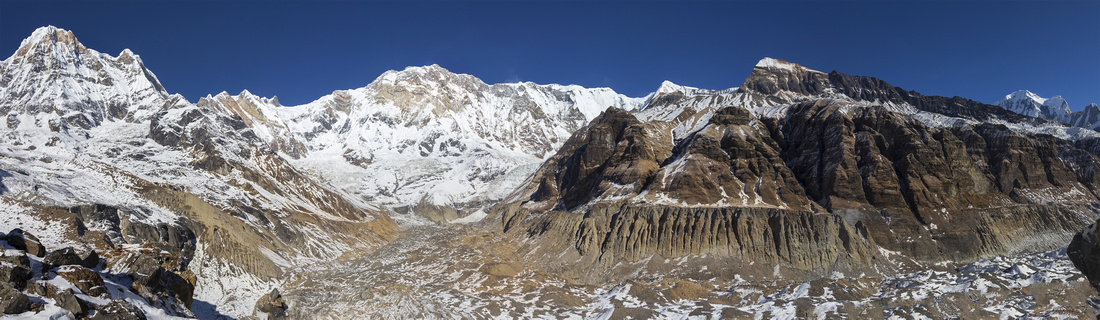 Annapurna South (7219m) upper left; Annapurna I (8091m), world 10th highest peak, center. Tent Peak (5850m) foreground right of center, distant Mt. Ganggapurna (7454m) extreme upper right. South Annapurna Glacier below Annapurna South (7219m) upper left; Annapurna I (8091m), world 10th highest peak, center. Tent Peak (5850m) foreground right of center, distant Mt. Ganggapurna (7454m) extreme upper right. South Annapurna Glacier below
Annapurna Range Panorama from Terminal Moraine above South Annapurna Glacier |
|
Annapurna Base Camp (ABC) is one of most popular treks in the world. Significantly different from celebrated Annapurna Circuit that circles outside perimeter, ABC trek goes straight into the "heart" of Annapurna Range horseshoe. Despite relatively low (for Himalayas) altitude, it is quite demanding. It is sometimes nicknamed "staircase trekking" because of 1000s of stone stairs one must climb and descend while bridging deep gaps between Nepalese villages resulting in cumulative elevation gain significantly higher from net difference between start (Nayapul, 1050m) and end (ABC, 4130m). In addition plenty of time is spent trekking below treeline and rewards in terms of alpine scenery come quite late. But once you reach glacial cirque at Machhapuchre Base Camp and start climbing towards ABC it feels really special; once in a lifetime kind of thing. Lots of Nepal treks are generally about the journey, but ABC to me was more about the destination; feeling of awe and magic finally reaching iconic place surrounded by impossibly high Himalaya peaks that feel like domain of gods. Views of unclimbed Mt. Machhapuchre (Fish Tail), rumored to be residence of Lord Shiva in Hindu religion and thus off limits to people, were particularly special. |
||||||||||||||||||||||||||||||||||||||||||||||||||||
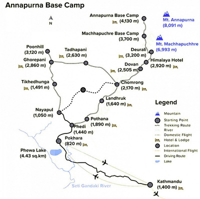 ABC Trekking map, including Poon Hill extension shared with Annapurna Circuit. ABC Trekking map, including Poon Hill extension shared with Annapurna Circuit.
Map of Annapurna Base Camp Trekking Route with Poon Hill extension (shared with last part of Annapurna Circuit). Initial part is either flight or tourist bus from Kathmandu to Pokhara, followed by local bus / taxi to Nayapul where walking starts and ends. In lower part there are several approach alternatives, but after Chomrong village there is only one way that ascends deep gorge of Modi Khala river.
My trek, starting from Pokhara after completion of Annapurna Circuit, took place over 9 days from Dec 16 to Dec 25 '19. Day-to-Day account is summarized below; click on the link for each day full details and photos . Metrics are approximate as I didn't have GPS. Elevation estimate is considerably higher from net difference between start and end points because of up and down nature of trail. |
||||||||||||||||||||||||||||||||||||||||||||||||||||
Thinking about doing ABC trek yourself? See this page for tips on preparation, logistics and variety of other useful links. |
||||||||||||||||||||||||||||||||||||||||||||||||||||