Google Map |
Rockies :: Icefields :: Jimmy Junior |
GPS Track |
 
Jimmy Junior Summit Panorama. Ascent ridge rising above Bow Lake lower center |
|||
| Trip Summary | |||
July 11, 2025Mt. Jimmy Simpson above Bow Lake is widely considered one of best easy scrambles on the Icefields. With good reason - I've done it twice, and scenery is spectacular. East outlier, lower by some 250m, has been dubbed "Jimmy Junior", and is less frequently visited. Approach is completely different, which further adds to appeal if you've been to main summit. Outing is short and sweet, and it offers huge reward/effort ratio; overall scenery might even be better! There are no difficulties and except for 2 easy gullies, one lower down and second directly below the summit entire ascent is just moderately steep hiking. In terms of routefinding main issue is identifying correct turnoff from Bow Lake trail -- if you use GAIA, don't - there are 2 turnoffs and both are wrong. Correct spot, see Map below Abstract and download GPX file from Top of Page, has well defined trail with minimal bushwhack that brings you within 30min to treeline. Lower cliff above can be scaled at different points, but easiest is gully at far climber left. View from start of south ridge is stupid beautiful, and reason by itself to go here even if you don't want to continue all the way. Higher up good trail can be found at climber left. Final summit block looks as if it might pose an issue, but it's just brief classic Rockies talus gully, class 2 at most. Summit had huge cairn and register during my July '25 visit.
Descent is the same way, and you will have in-your-face view of magnificent Bow Lake the entire way before treeline. Word of caution: If curious about faulty GAIA track dropping directly from start of South Ridge, resist the urge to investigate. It is wrong and can lead to serious trouble, as seen on several videos posted by Social Media hikers floating on Internet. |
|
Gallery |
|||
 Num-Ti-Jah lodge
Jimmy Junior ascent route above Num-Ti-Jah lodge near Bow Lake parking Num-Ti-Jah lodge
Jimmy Junior ascent route above Num-Ti-Jah lodge near Bow Lake parking |
|||
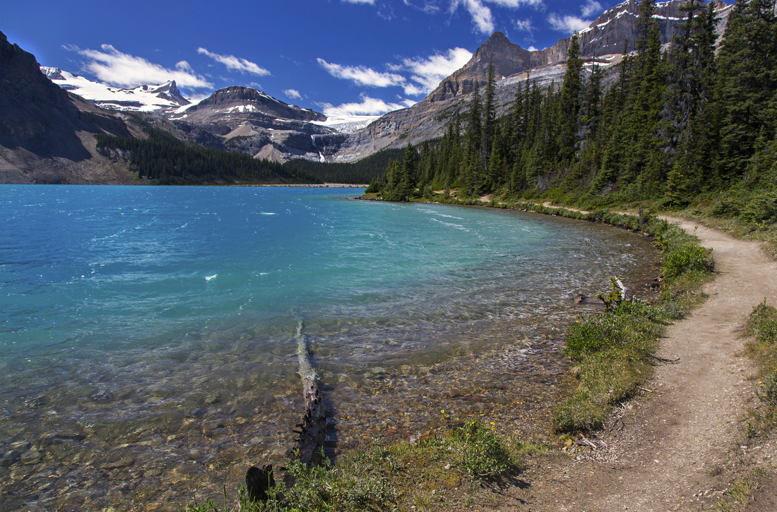 Initial hiking around Bow Lake
 |
|||
 Jimmy Junction
Unmarked junction ~1km along Bow Lake Trail; turn right. Waypoint '1 - Bow Lake', GPS download Top of Page Jimmy Junction
Unmarked junction ~1km along Bow Lake Trail; turn right. Waypoint '1 - Bow Lake', GPS download Top of Page |
|||
 Jimmy Junction
Ignoring faulty GAIA tracks and following well defined Jimmy Jr Approach Trail with minimal bushwhack Jimmy Junction
Ignoring faulty GAIA tracks and following well defined Jimmy Jr Approach Trail with minimal bushwhack |
|||
 Treeline Views
Looking back after reaching treeline 30-35min from Bow Lake (Waypoint '2 - Treeline') Trail becomes less defined - watch for cairns Treeline Views
Looking back after reaching treeline 30-35min from Bow Lake (Waypoint '2 - Treeline') Trail becomes less defined - watch for cairns |
|||
 Lower Gully
Easy, somewhat lose, talus gully breaches lower cliffband to start of South Ridge Lower Gully
Easy, somewhat lose, talus gully breaches lower cliffband to start of South Ridge |
|||
 Bow Lake
Fantastic Bow Lake Viewpoint awaits after topping up lower Talus gully Bow Lake
Fantastic Bow Lake Viewpoint awaits after topping up lower Talus gully |
|||
 Icefields Panorama
 from start of South Ridge. It is worth getting here for this view even if not going all the way. Icefields Panorama
Icefields Panorama from start of South Ridge. It is worth getting here for this view even if not going all the way. |
|||
 Twin Cairns
Two cairns marking start of South Ridge Twin Cairns
Two cairns marking start of South Ridge |
|||
 South Ridge
Straightforward moderately steep south ridge ascent. Trend climber left South Ridge
Straightforward moderately steep south ridge ascent. Trend climber left |
|||
 Landmark Cairn
Very large cairn at edge of dropoff, visible from below, doesn't mark anything but looks nice Landmark Cairn
Very large cairn at edge of dropoff, visible from below, doesn't mark anything but looks nice |
|||
 Twin Tarns
Higher up unnamed tarn comes into view; Iceberg Lake feeding Bow Falls behind Twin Tarns
Higher up unnamed tarn comes into view; Iceberg Lake feeding Bow Falls behind |
|||
 Summit Ridge
Following good trail on climber left. Jimmy Jr. summit upper right Summit Ridge
Following good trail on climber left. Jimmy Jr. summit upper right |
|||
 Summit Ridge
Final traverse to summit block, climbed head on Summit Ridge
Final traverse to summit block, climbed head on |
|||
 Upper Gully
Short scramble up Talus gully breaching summit block Upper Gully
Short scramble up Talus gully breaching summit block |
|||
 Upper Gully
Looking back after scrambling upper gully. This spot is marked by small cairn, lower left Upper Gully
Looking back after scrambling upper gully. This spot is marked by small cairn, lower left |
|||
 Jimmy Jr Summit
Jimmy Jr 2775m summit with large cairn and register Jimmy Jr Summit
Jimmy Jr 2775m summit with large cairn and register |
|||
 West Bow Peak
View north from Jimmy Jr summit; Peyto area peaks behind West Bow Peak
View north from Jimmy Jr summit; Peyto area peaks behind |
|||
 Lower Tarns
Several small tarns in glacial basin below can be seen by descending briefly on the north side Lower Tarns
Several small tarns in glacial basin below can be seen by descending briefly on the north side |
|||
 Observation Peak
 Telephoto, moderate scramble on Icefields east side Observation Peak
Observation Peak Telephoto, moderate scramble on Icefields east side |
|||
 |
Abstract
|
Overall Difficulty |
Mostly moderately steep hiking with 2 short Talus gullies (class 2) |
||||
|
Snow Factor |
Frequent winter ski ascent. South facing slopes need stable snow conditions |
||||
|
Scenery |
Stupid beautiful aerial Bow Lake View. Fab Icefields corridor Panorama incl. distant Siffleur peaks. Wapta Icefield. |
||||
|
Trail/Marking |
Good |
Reasonably well defined trail to treeline with occasional flags. Way becomes obvious on South Ridge |
|||
|
Suggested Time |
5 hr |
Return time with moderate pace |
|||
|
Elevation |
Start: 1950 m Max: 2775m Total: ~850m |
Round Trip: 8km | |||
|
Gear |
Full hiking boots, gaiters and poles. Climbing helmet essential in group (rockfall danger). GPS helpful |
||||
|
Water |
No reliable water source. Carry 2L, depending on Season |
||||
|
Dog Friendly |
Yes |
Standard back-country travel precautions |
|||
 Jimmy Junior GAIA Map
 Jimmy Junior Elevation Profile