Google Map |
Rockies :: Yoho :: Yoho Glacier |
GPS Track |
 
Upper Yoho Valley Panorama at end of cairned route. Yoho Glacier Toe is behind "V" shaped canyon feature roughly center |
|||
| Trip Summary | |||
September 16, 2025Real payout on Yoho Glacier Trail comes if continuing past official trail end. The name is misleading as glacier has retreated due to global warming, and only view might actually be at very beginning! But Yoho valley trail is excellent and travel is very fast, with several scenic distractions along the way. Past signed Twin Falls turnoff ~6.5km from Takkakaw trailhead (Waypoint '2 - Twin Falls Junction', GPS download Top of Page) conditions become bit more rough with several sections with deadfall, but going is still easy. Trail ends at moraine bench above Yoho River and although glacier still can't be seen, there is excellent view of Waves Creek drainage and real Yoho National park wilderness (see Gallery). It appears one might be able to follow Waves drainage on the other side, but crossing Yoho river is not feasible - at least not here.
I strongly recommend continuing to upper valley, ~40min past end of official Yoho Glacier trail. After dropping to river cairns lead the way on climber left side. Waterfalls start popping literally from everywhere. I scrambled by amazing 3-legged waterfall, then ended journey ~10km mark in rocky basin where following very young Yoho River became much more difficult. Cairns also stop here. Lead photo on the page illustrates this simply amazing place, likely seen by very few. It is possible though to continue, by scrambling talus slope on left side, then traversing treed bench trending right to Yoho Glacier overlook. Judging by topo maps it is also feasible to reach col above Guy (Des Poilus) Hut, so this could also be alternate Yoho Peak scramble route. It also might be feasible to traverse east just below snout of Yoho glacier, then utilize bench below south outlier of Mt. Gordon to reach upper Waves creek drainage and visit rarely seen Diableret Falls below Balfour Pass. This would require either backpack or ACC Balfour Hut overnight (normally used on famous winter Wapta ski traverse, but open year round). |
|
Gallery |
|||
 Takkakaw Trailhead
Trailhead Table with posted distances just past Takkakaw campground Takkakaw Trailhead
Trailhead Table with posted distances just past Takkakaw campground |
|||
 Yoho Glacier
Only view of Yoho Glacier (distant center) is actually near the trailhead Yoho Glacier
Only view of Yoho Glacier (distant center) is actually near the trailhead |
|||
 Takkakaw Fall
View back to Takkakaw Falls where tourist gong show never seems to stop Takkakaw Fall
View back to Takkakaw Falls where tourist gong show never seems to stop |
|||
 Angel Staircase
Brief side trip for this view of Angel Staircase route to rarely visited Takkakaw Lake, ultimate source of Takkakaw Falls. Access is by following east side of Yoho River upstream from Takkakaw Falls for about an hour (Ignore faulty vanity GAIA track that leads into serious trouble) Angel Staircase
Brief side trip for this view of Angel Staircase route to rarely visited Takkakaw Lake, ultimate source of Takkakaw Falls. Access is by following east side of Yoho River upstream from Takkakaw Falls for about an hour (Ignore faulty vanity GAIA track that leads into serious trouble) |
|||
 Little Yoho River
Bridged crossing of Little Yoho River by Laughing Falls campground ~1hr from Takkakaw Little Yoho River
Bridged crossing of Little Yoho River by Laughing Falls campground ~1hr from Takkakaw |
|||
 Laughing Falls
 just before Little Yoho junction are brief scenic distraction Laughing Falls
Laughing Falls just before Little Yoho junction are brief scenic distraction |
|||
 Forest Trail
Typical section of forest trail past Twin Falls junction with old boards bridging swampy sections Forest Trail
Typical section of forest trail past Twin Falls junction with old boards bridging swampy sections |
|||
 Trail End
Official Yoho Glacier Trail ends at this overlook ~8.5km from Takkakaw. Cairned route descends to the river, then continues upstream on left side Trail End
Official Yoho Glacier Trail ends at this overlook ~8.5km from Takkakaw. Cairned route descends to the river, then continues upstream on left side |
|||
 Waves Drainage
Confluence of Yoho River and Waves Creek draining Diableret Falls below Balfour Pass. South Outlier of Mt. Gordon rising above Waves Drainage
Confluence of Yoho River and Waves Creek draining Diableret Falls below Balfour Pass. South Outlier of Mt. Gordon rising above |
|||
 River Route
Following young Yoho river upstream. Route now becomes a scramble River Route
Following young Yoho river upstream. Route now becomes a scramble |
|||
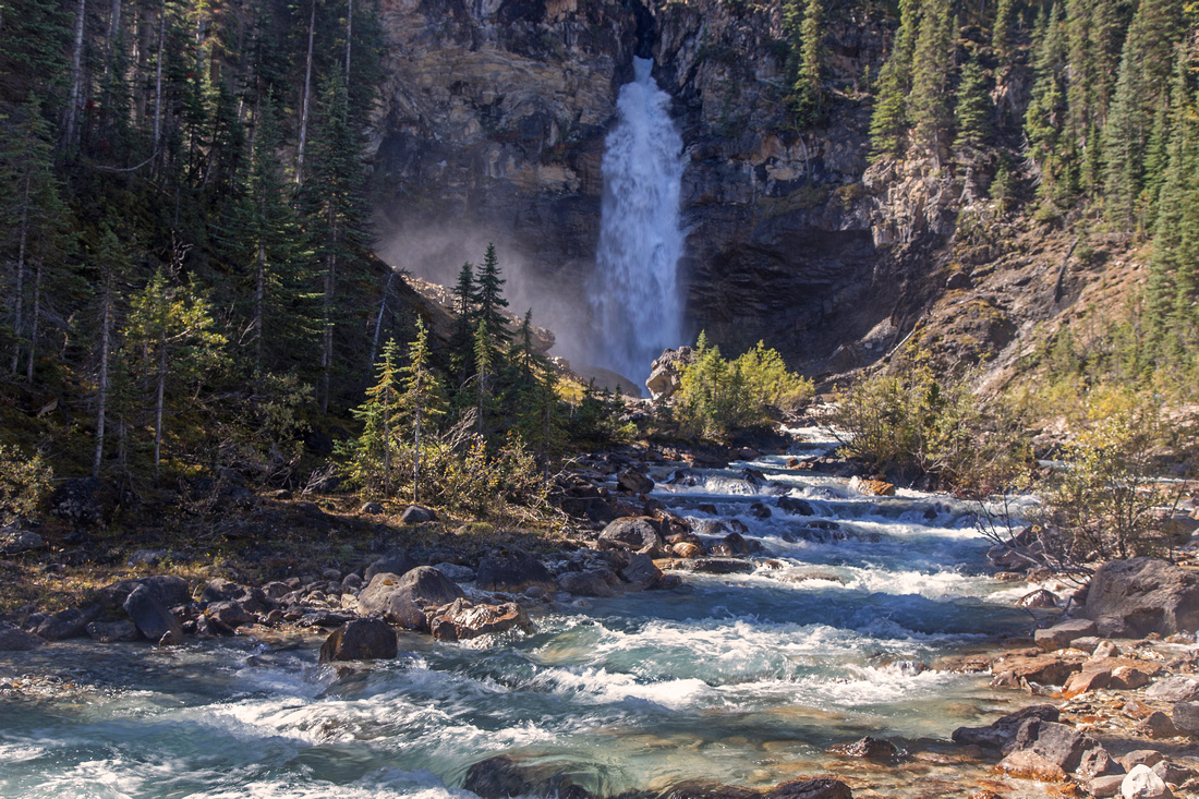
 3-Legged Waterfall
3-legged waterfall higher up is major scenic highlight 3-Legged Waterfall
3-legged waterfall higher up is major scenic highlight |
|||
 Upper Cascades
Waterfalls popping from everywhere as route approaches upper Yoho valley. Cairns stop around here. I turned back shortly after (lead photo), but I am fairly certain that by scrambling talus slope left then angling right one could reach toe of Yoho Glacier. Judging by various maps this is likely alternate route to col above Guy (Des Poilus) ACC Hut - Yoho Peak scramble route Upper Cascades
Waterfalls popping from everywhere as route approaches upper Yoho valley. Cairns stop around here. I turned back shortly after (lead photo), but I am fairly certain that by scrambling talus slope left then angling right one could reach toe of Yoho Glacier. Judging by various maps this is likely alternate route to col above Guy (Des Poilus) ACC Hut - Yoho Peak scramble route |
|||
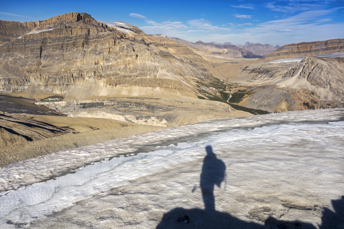 My own photo from Yoho Peak summit looking east to upper Waves Creek drainage. Yoho Glacier toe extreme left. Talus bench roughly center might offer scramble route to very rarely seen Diableret Falls and Balfour Pass
 |
|||
 Waterfalls Valley
Looking back from my turnaround point; pointy Trolltinder Peak center, Takkakaw Peak to its right Waterfalls Valley
Looking back from my turnaround point; pointy Trolltinder Peak center, Takkakaw Peak to its right |
|||
Abstract
| Overall Difficulty | D3 | Trail hiking with some rocky/rooty sections past Twin Falls turnoff. Occasionally lose talus route with couple of easy scrambling steps past end of official trail | |||
| Snow Factor | S2 | Unlikely candidate for ski winter trip. Snowshoe trip definitely not feasible as Takkakaw road is not plowed. Could be considered as alternate ending to classic Wapta Traverse, but highly unlikely | |||
| Scenery | Waterfalls. Upper valley past end of official Parks trail literally out-of-this-world | ||||
| Trail/Marking | Excellent / none | Official maintained Parks trail with signed junctions to bench above Yoho river; cairned route afterwards | |||
| Suggested Time | 6 hrs | Return time from Takakkaw Falls to upper valley as presented in this report. Much potential for further exploration | |||
| Elevation | Start: 1500m Max: 1885m Total: ~500m | Round Trip: ~20km | |||
| Gear | Day hikers; poles helpful if continuing past end of official trail | ||||
| Water | Many creeks and glacial melts. Silty water might need to be treated | ||||
| Dog Friendly | Yes | Standard back-country travel precautions | |||
 Yoho Glacier GAIA Map
 Yoho Glacier Elevation Profile