Google Map |
USA :: San Diego :: Fry Koegel Loop |
GPS Track |
|
San Diego County Inland Panorama from Fry Koegel Viewpoint near Mt. Woodson trail junction. Lake Poway extreme center left |

| Trip Summary | |||
Jan 31, 2024
Pleasant alternative to usual Mt. Woodson Trail from starting from Lake Poway - Blue Sky Preserve. Most people reaching Mt. Woodson summit from the East walk paved service Road, but far better alternative is nearby Fry-Koegel County Trail. Besides avoiding Social Media Urban Hiker gong show bound for Potato Chip Rock selfies, it also offers real hiking feel. Main disadvantage is lack of Parking as one has to leave car at Ramona Road (Hwy67) shoulder. Besides not being safe, there are also many break-ins; witnessed by shattered glass littering the roadside. Parking on Archie Moore road where Fry Koegel officially starts is not allowed unless you are Golf Club Member. On my Trip in late Jan '24 after reaching Fry Koegel / Lake Poway junction I walked up to Mt. Woodson, then closed the loop by descending the service road and this is how this Trip Report (Gallery / GPS) is organized. Alternative is simply returning the same way after checking the Fry Koegel Viewpoint as you are likely to be by yourself the whole day.
|
|
Gallery |
|||
 Fry Koegel Trailhead Fry Koegel Trailhead Fry Koegel Trailhead at Archie Moore Road by Woodson Golf Club
 |
|||
 Residential Hill
Initial approach climbing Hillside by Residential Area. Mt. Woodson summit above Residential Hill
Initial approach climbing Hillside by Residential Area. Mt. Woodson summit above |
|||
 Leaf Epidermis
Colorful Maple Leaf along Residential Fence Leaf Epidermis
Colorful Maple Leaf along Residential Fence |
|||
 Shady Trail
Very pleasant shady Trail hiking on Mt. Woodson North side Shady Trail
Very pleasant shady Trail hiking on Mt. Woodson North side |
|||
 Mt. Woodson
Open views of Mt. Woodson as Fry Koegel approaches Lake Poway Trail Junction Mt. Woodson
Open views of Mt. Woodson as Fry Koegel approaches Lake Poway Trail Junction |
|||
 Old Fry Koegel Junction
Woodson Ridge shortcut ~45min from Hwy67; even if planning on loop return it is better to continue straight to Fry Koegel Viewpoint Old Fry Koegel Junction
Woodson Ridge shortcut ~45min from Hwy67; even if planning on loop return it is better to continue straight to Fry Koegel Viewpoint |
|||
 Lake Poway Trail Junction
Lake Poway Trail junction, about an hour from Hwy67, and end of Fry Koegel Trail Lake Poway Trail Junction
Lake Poway Trail junction, about an hour from Hwy67, and end of Fry Koegel Trail |
|||
 Lake Poway
 Telephoto from Fry Koegel Viewpoint. Ridge Trail coming from the West below Lake Poway
Lake Poway Telephoto from Fry Koegel Viewpoint. Ridge Trail coming from the West below |
|||
 Lake Ramona
 Telephoto from Fry Koegel Viewpoint Lake Ramona
Lake Ramona Telephoto from Fry Koegel Viewpoint |
|||
 Mt. Woodson
Great view of Mt. Woodson, 35-40min away, from Fry Koegel Viewpoint. Iron Mountain center right background Mt. Woodson
Great view of Mt. Woodson, 35-40min away, from Fry Koegel Viewpoint. Iron Mountain center right background |
|||
 San Diego County
 Inland Panorama already on standard Mt. Woodson Trail from Lake Poway. Fry Koegel Viewpoint Rock Outcrop center right San Diego County
San Diego County Inland Panorama already on standard Mt. Woodson Trail from Lake Poway. Fry Koegel Viewpoint Rock Outcrop center right |
|||
 Boulder Rock
Very picturesque boulder while ascending Mt. Woodson Ridge that always brings smile to my Face Boulder Rock
Very picturesque boulder while ascending Mt. Woodson Ridge that always brings smile to my Face |
|||
 Potato Chip Rock
Infamous Potato Chip Rock Panorama near Mt. Woodson Summit. You have to be really lucky to catch this spot without human monkeys posing for Social Media selfies Potato Chip Rock
Infamous Potato Chip Rock Panorama near Mt. Woodson Summit. You have to be really lucky to catch this spot without human monkeys posing for Social Media selfies |
|||
 Woodson Backside Road
Looking back to Mt. Woodson Telecom Towers on backside road descent back to Hwy66 Woodson Backside Road
Looking back to Mt. Woodson Telecom Towers on backside road descent back to Hwy66 |
|||
 Boulder Passage
Backside Road passing through some giant Boulders Boulder Passage
Backside Road passing through some giant Boulders |
|||
 Dry Skyline
Dried out Tree with distant views of Cuyamaca Rancho State Park. Mt. Cuyamaca, highest in San Diego County, center right Dry Skyline
Dried out Tree with distant views of Cuyamaca Rancho State Park. Mt. Cuyamaca, highest in San Diego County, center right |
|||
 Potato Chip Trailhead
Potato Chip Rock sign as Backside Road descends back to Hwy67, few 100's of meters from Fry Koegel Trailhead (first Gallery Photo) Potato Chip Trailhead
Potato Chip Rock sign as Backside Road descends back to Hwy67, few 100's of meters from Fry Koegel Trailhead (first Gallery Photo) |
Abstract
| Overall Difficulty | D3 | Moderately steep sections with rocky steps. Cumulative distance and elevation exceed average Poway area hikes | |||
| Scenery | Sweeping Panorama of San Diego County Inland and Cuyamaca/Laguna to the East. Instagram crazy Potato Chip Rock | ||||
| Trail/Marking | Excellent | Well defined trail maintained by City of Poway with marked junctions | |||
| Suggested Time | 4hrs | Full loop start/end at Lake Ramona Road (Hwy67) | |||
| Elevation | Start: 505m Max: 880m Total: ~470m | Round Trip: ~10km | |||
| Gear | Day Hikers or Full Hiking Boots. Hiking poles helpful | ||||
| Water | Dry hike. Carry min 2L, more in summer heat (1 gallon recommended by Lake Poway Park) | ||||
| Dog Friendly | Yes | Dogs should be leashed past Fry Koegel/Lake Poway trail junction. Beware of rattlesnakes in season | |||
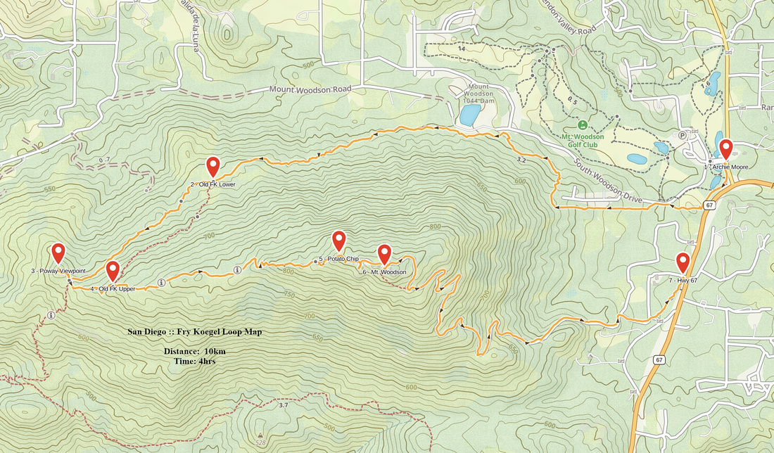 Fry Koegel Loop GAIA Map
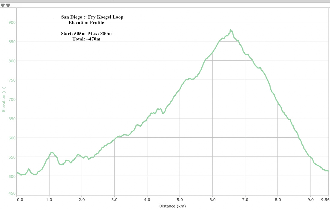 Fry Koegel Loop Elevation Profile