Google Map |
Rockies :: Kananaskis :: The Turret |
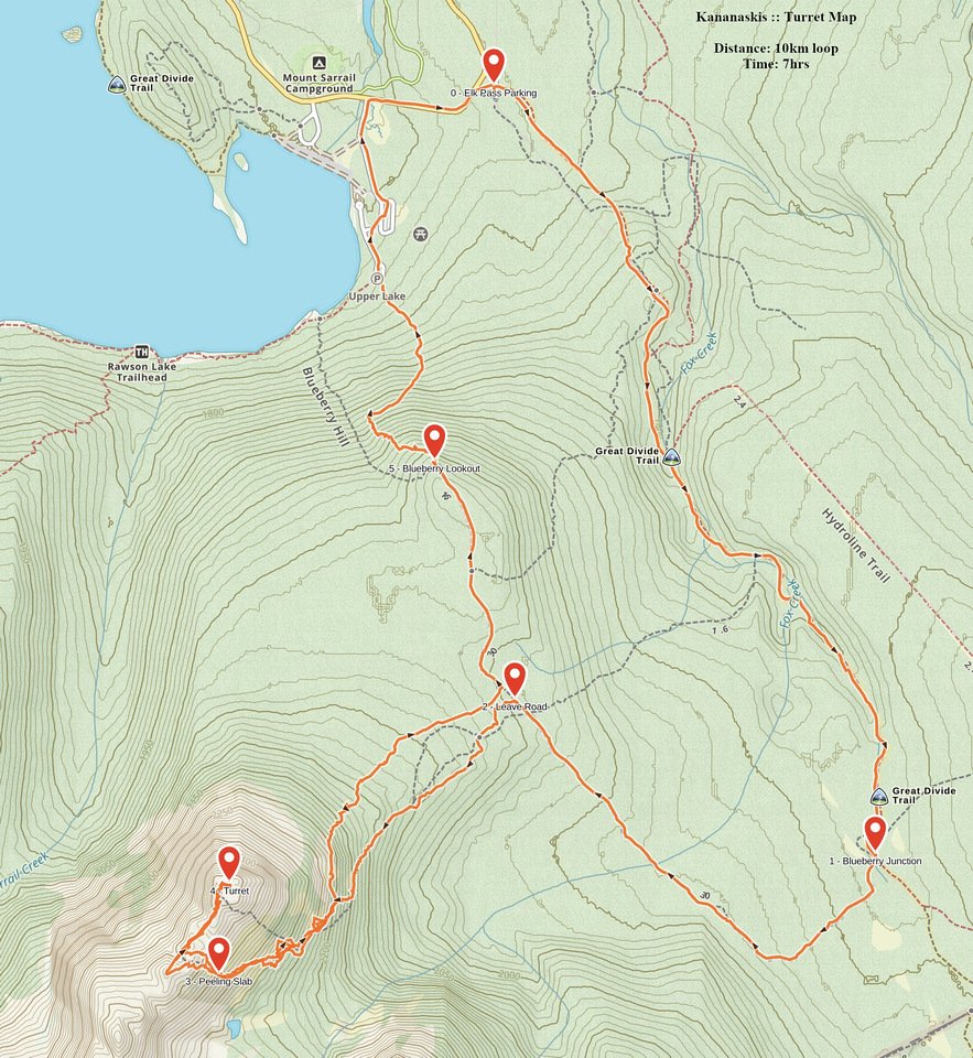
GPS Track |
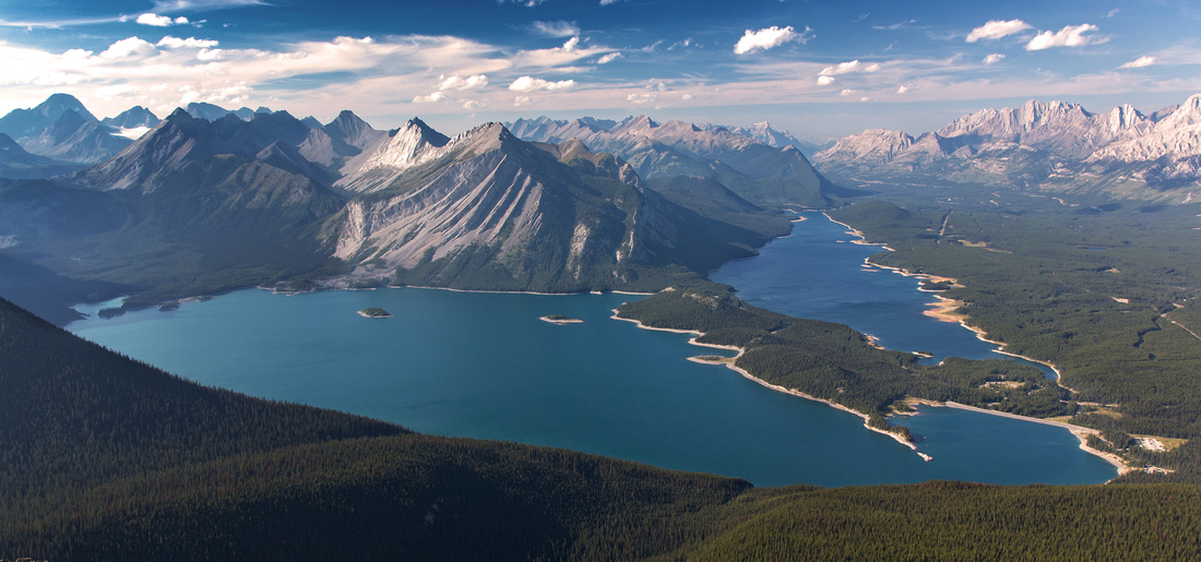 
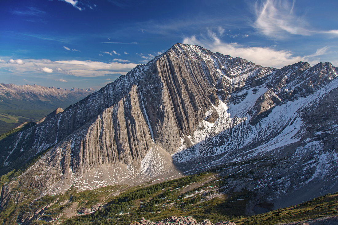
Panoramic view of Kananaskis Lakes from summit of the Turret |
|||
| Trip Summary | |||
August 23, 2015The Turret is distinctive peak just off BC/Alberta border spanning long ridge that joins Mt. Fox and Mt. Foch. East slopes viewed from upper K-lake parking lot it appear impregnable. As is often the case, back side is much tamer and accessible to hikers that can handle some light scrambling on steep slopes. However this trip is not for anyone that is not comfortable bushwhacking and finding their own way, as there are no trails past Blueberry Lookout X-country ski road. Summit views are phenomenal and include jaw dropping panorama of Kananaskis lakes, Mt. Fox and long Pocaterra ridge across the valley. Approach is fairly roundabout and mountain bike is recommended. Another option is loop return by trashing down from the lookout directly to upper K-lake parking lot. Park at Elk pass parking lot past Boulton bridge and about a kilometer before upper K-lake turnoff. Follow wide forest road (Elk pass trail) for about 45 minutes or so. This road is easily cycle-able; however note that cycling is not allowed continuing to Elk Pass once past BC/Alberta provincial border. If you bring the bike, you might need to push on initial hill to top of powerline (both ways). Going further this road has been washed out during 2013 floods, but bridges have now been restored and travel is easy again. Leave Elk Pass trail once you reach meadows and large bench; turn right here and head up on Blueberry ski road. Note that this area is prime grizzly hot-spot, and regular sightings occur -- be alert and make lots of noise. This road heads towards the valley sandwiched between Mt. Fox and the Turret, then turns right towards upper K-lake and the lookout. It is obvious how roundabout this approach is, but resist the urge to trash towards the Turret too soon as this will lead to very tedious -and unnecessary- bushwhack. Instead continue on the road till you about in-line with the Turret -- about 20-30 minutes past Elk Pass junction. Here leave the road, and take direct line towards the Turret. You might stumble upon odd animal trail angling left, but do not follow them. Instead keep going straight; this has least amount of bushwhacking. About 30 minutes past Blueberry ski road is steeper rise that leads to larch island on top and cliffs near treeline. Turn left here and contour on faint trail that initially descends a bit, then disappears. Easiest way is to stay as high as possible aiming to low col between the Turret and outlier of Mt. Fox. Do not go all the way to the col; instead, once cliffs have eroded look for suitable place to break uppermost band of vegetation; odds are you will choose slick peeling slab in wide gully that can be scrambled without difficulty. Above this slab summit ridge is directly above you. You can angle right more directly towards the summit, but this leads to some very lose and unstable scree in upper part. Instead, it is easiest to angle left as this way most of the steep hike up is on grass. Once you intersect the ridge, fantastic panorama unfolds and will have you reaching for your camera! Final ridgewalk leading to the summit is the only real scrambling part of the ascent. Like most ridges it is easiest to stay directly on the crest. It is hard not to notice drop on the left (north) side, but it is nothing too alarming as the ridge is wide enough. Drop on the right side to bypass bit of gendarme approaching final summit block, then scramble on lose talus and bits of trail to summit cairn. In 2015 register was empty. Return the same way, probably using GPS to orient in the forest. If you brought the bike ride back will be rememberable. If not, alternate option is to continue to Blueberry lookout (bench with semi-obscured views of upper K-lake at end of ski road). From there trash down initially heading left (direct line is too steep). You might encounter trail here. Once the slope to your right becomes more mellow, simply make bee line through the bush line. Loud noises of tourists on picnic benches might serve as beacon, and for once be welcome and not loathed. |
|
Gallery |
|||
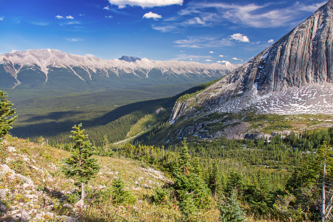 Traversing south slopes with views of Pocaterra ridge
 |
|||
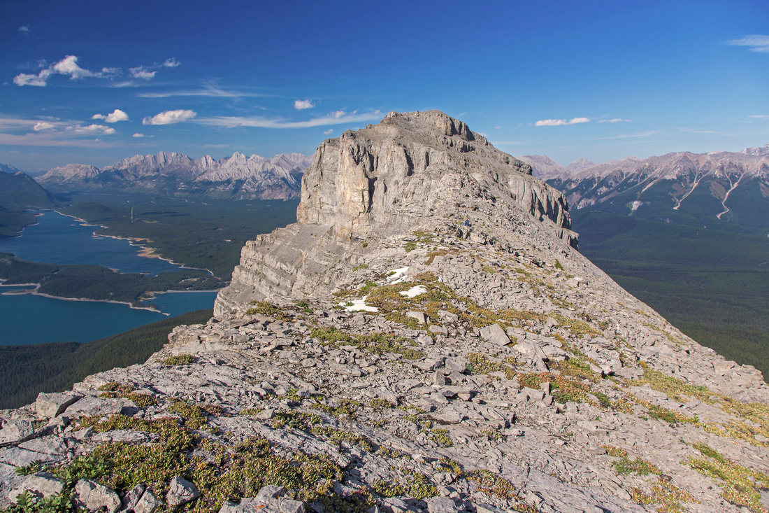 Turret summit ridge; ~ 15 minutes of easy scrambling
 |
|||
View back to Turret ridge from the summit. Mt. Foch behind |
|||
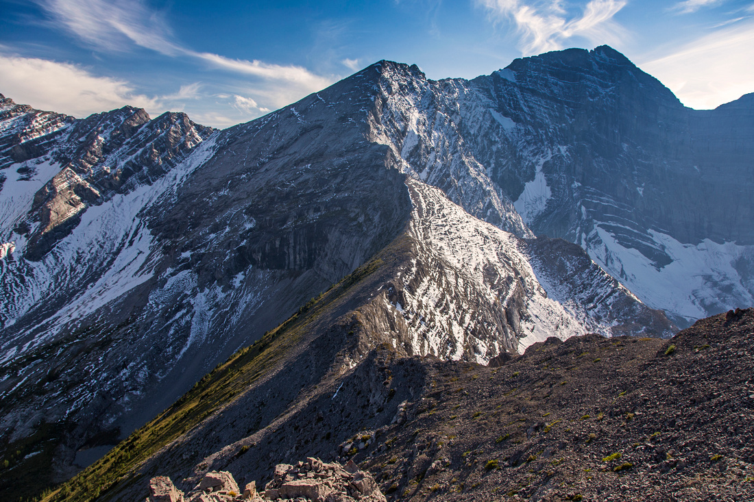
 Mt. Fox (difficult Kane scramble) from the Turret
 |
Abstract
| Overall Difficulty | D5 | Bushwhack with no trails, with possibility of some tedious undergrowth. Steep side-hilling and grass/talus slopes. Easy ridge scrambling with moderate exposure. | |||
| Snow Factor | S4 | Very steep south slopes make this ascent unlikely winter trip candidate (avalanche danger) | |||
| Scenery | Jaw dropping postcard Kananaskis Lakes panorama. Spectacular north aspect of Mt. Fox. Far reaching views to Pocaterra ridge | ||||
| Trail/Marking | None | Initial approach on wide forest road. No trail or marking past Blueberry ski road. | |||
| Suggested Time | 7 hr | Bringing the bike will shave about an hour. Alternate return via bushwhack to upper K-lake saves about 1/2 hour | |||
| Elevation | Start: 1660m Max: 2560m Total: ~1000m | Round Trip: 10km (loop descent, more if returning the same way | |||
| Gear | Full hiking boots recommended. Hiking Poles for stability on steep south slopes. Gaiters are helpful. GPS is essential | ||||
| Water | Fox creek on Elk Pass trail, but none afterwards. Carry ~2L | ||||
| Dog Friendly | Yes | Prime grizzly habitat - keep control of your dog at all times | |||
 Turret GAIA Map
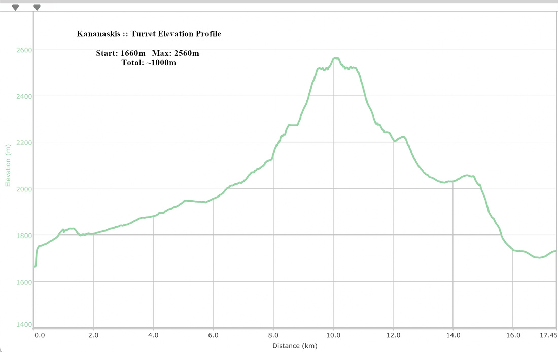 Turret Elevation Profile