Google Map |
Rockies :: Banff-Louise :: Consolation Lakes |
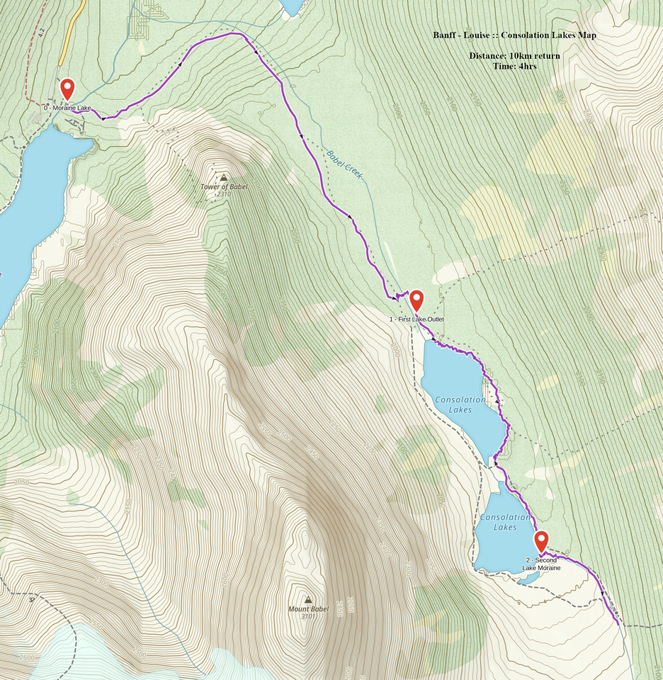
GPS Track |
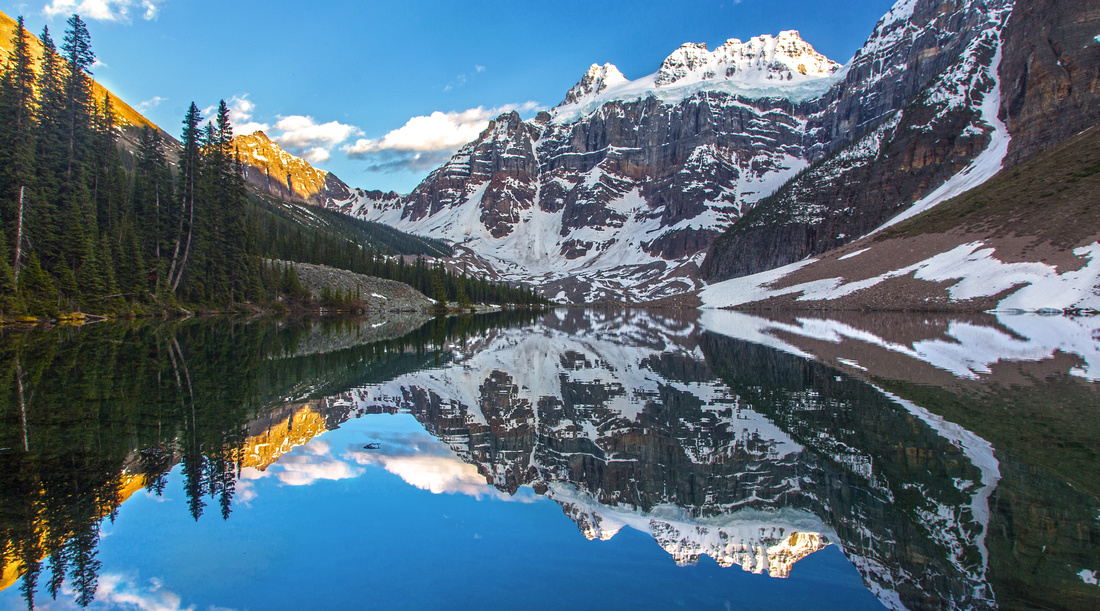 
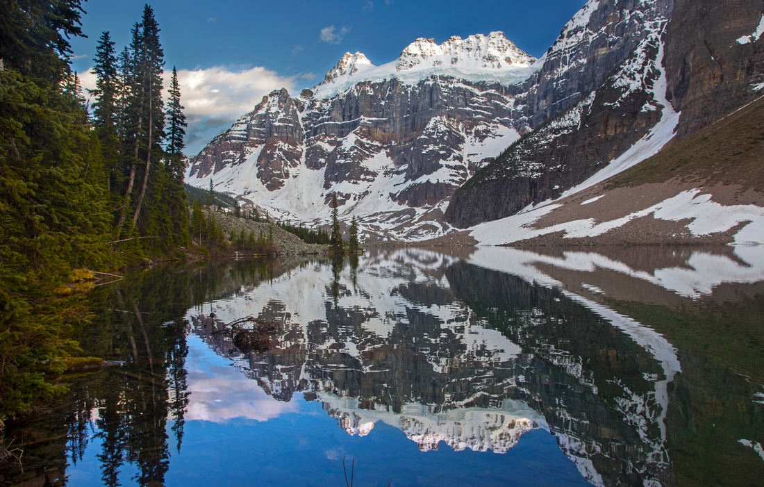
Fabulous early evening reflections of Mt. Quadra in lower Consolation Lake |
|||
| Trip Summary | |||
May 24, 2016
Half-day trip starting from Moraine Lake and leading into beautiful valley tucked between Mt. Bident, Quadra and Panorama Ridge hosting duo of sparkling alpine lakes. Wide park trail ends at north end of the first lake and this is as far as most casual visitors go. Hikers seeking solitude can extend the trip by fording lake outlet, then follow rough trail on east side to second lake. There are several options for further exploration, including scramble of Panorama Ridge (class 2 at most) or terrific hike to Consolation Pass and possible crossover to Boom Lake.
Park (if you can find the spot!) at Moraine Lake, some 16km from junction at Lake Louise. The road is not plowed in winter and closed for traffic. Usual opening is after the May long weekend. Moraine Lake is trademark Rockies, but onslaught of summer visitors make it less appealing for seasonal hiker. However most are satisfied by clambering on rock-pile above the lake for picture of the lake that used to be Canadian $20 dollar bill. Consolation Lakes trail continues across talus slope coming down from Tower of Babel. This pinnacle is also a scramble, but fairly dangerous as narrow gully leading to the summit is very loose and has plenty of rockfall. Consolation trail turns right and climbs gently towards the valley. Rushing Babel creek is constant companion and there are several very nice spots for photographers (did you bring the tripod?) About 15-20 minutes before the lake is marked Taylor junction -- it leads on east side of Panorama ridge towards Taylor lake. This trail is not maintained anymore and entirely under tree cover. Continue on main trail and reach first lake outlet in under an hour from Moraine trailhead. This is very beautiful place and camera will get busy, although you are not likely to have it to yourself.
To continue to the second lake look for suitable spot to ford the outlet to the other side. Best spot is maybe 100 meters before lake east end where channel is wide and shallow with several rock boulders you can --almost-- hop across on. Pair of old sandals is an asset; if you brought them, simply stash them on the other side for return trip. It is also possible to circumvent first lake on right (west) side. This is very awkward as large boulders must be negotiated on huge avalanche slope below Mt. Bident. It will take longer, but you won't have to get your feet wet as strip between the lakes is entirely dry -- suit yourself. Trail on the east side is flagged but frequently disappears in the bog. There is plenty of deadfall. Halfway across boulder slope must be negotiated; watch for flags at both ends. Finally you reach the second lake and there is an awesome spot right on the shore for a break. Trail continues around second lake and at far end exits on lateral moraine that curves gently towards Consolation Pass. Extension to Consolation Pass is more serious, full day trip. Early in season it will be snowbound and not feasible. The going is fairly easy and there is decent trail most of the way. Mt. Quadra with hanging glacier coming down its north aspect looks amazing and is well worth the effort. Return the same way.
Note: As of summer '23, driving to Moraine Lake is not allowed anymore. Parks Shuttle, Tour Buses or Cycling are alternatives. Parks Canada enforces the "group of 4" hiking rule. These rules constantly changes and create plenty of confusion. Consult Parks website, or stop as Parks office at Lake Louise for detail information.
|
|
Gallery |
|||
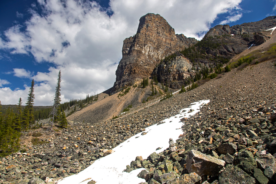 Consolation trail circles Tower of Babel on the left side
 |
|||
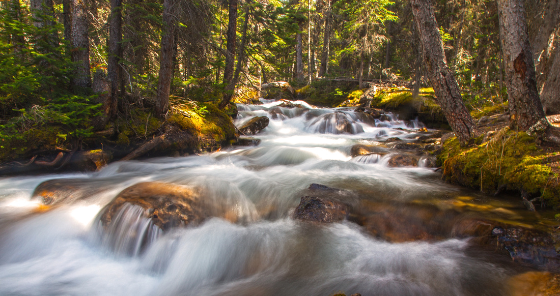 Babel Creek cascades hiking up Consolation Valley
 |
|||
|
|
|||
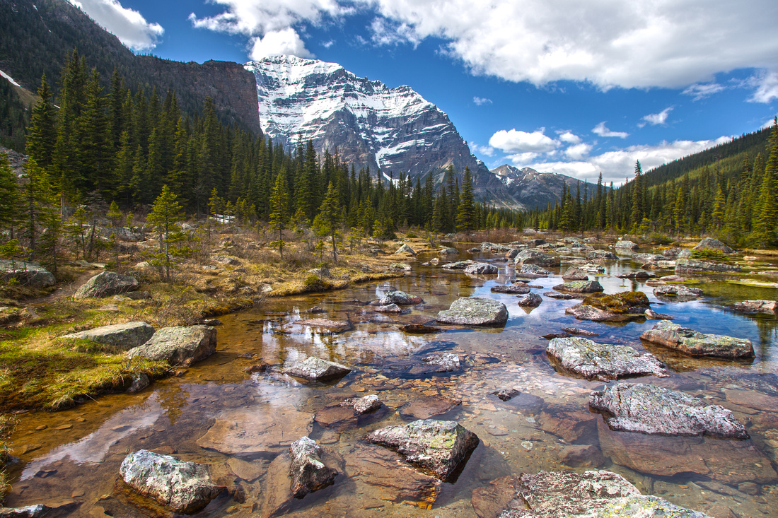 Views back towards Mt. Temple from first lake
 |
|||
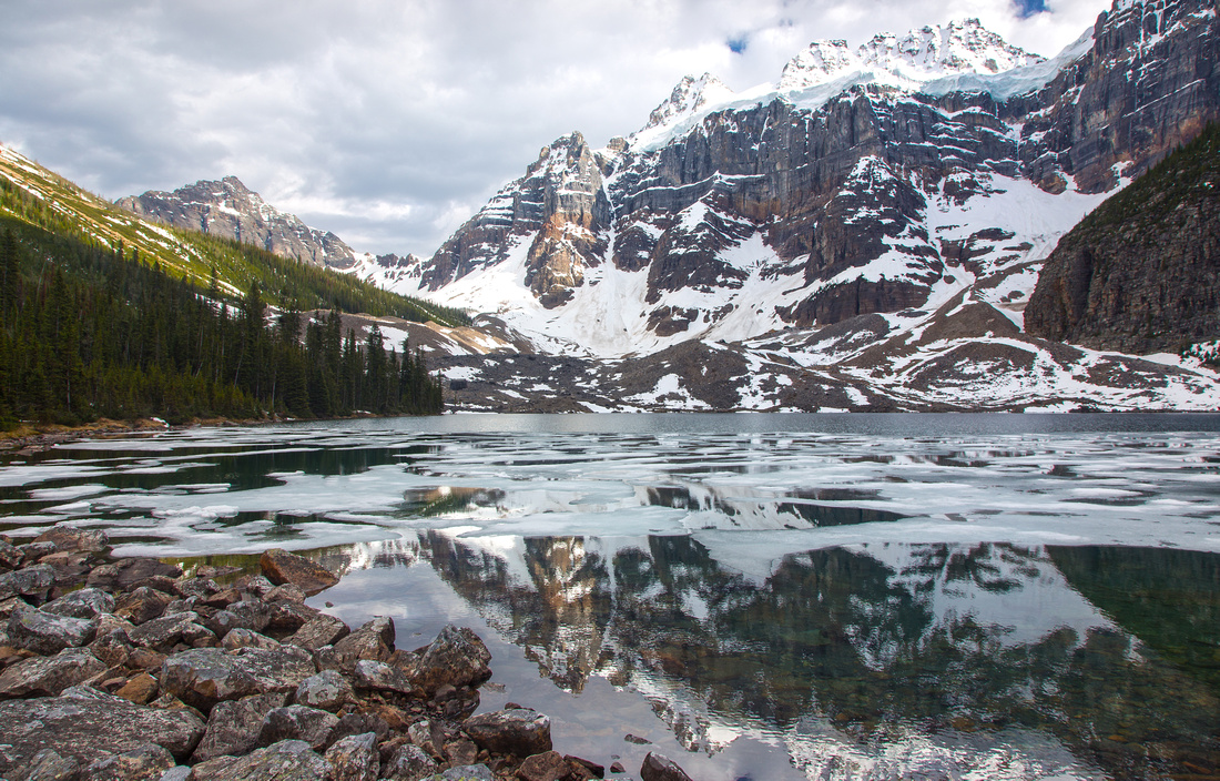
 Circling the first lake with great reflections in still water
 |
|||
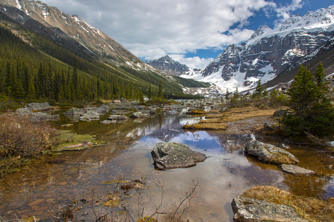
 Second Consolation Lake. Rough trail continues on left side
 |
Abstract
| Overall Difficulty | D2/3 | Rough trail with deadfall and boulder fields beyond first lake. Non-bridged crossing of lake outlet (ankle deep). | |||
| Snow Factor | S2 | Moraine Lake road is not plowed in winter; otherwise it would be straightforward snowshoe. Avalanche danger in Consolation Valley in early spring from both sides. | |||
| Scenery | Picture perfect glacial tarns. Pretty cascades of Babel Creek in spring. Glaciated Mt. Quadra. South face of Mt. Temple | ||||
| Trail/Marking | Excellent / Poor | Wide maintained park trail to first lake. Flagged route around the lakes frequently disappears in bog and thickets of bush. Cairns on moraine leading to Consolation Pass beyond second lake. | |||
| Suggested Time | 4 hr | Return time for second lake. If going just to first lake, 1 1/2 - 2 hours only. Add several hours if continuing to Consolation Pass | |||
| Elevation | Start: 1870m Max: 1950 m Total: ~150 m (Second Consolation Lake) | Round Trip: ~10 km (second Consolation Lake) | |||
| Gear | Hiking poles helpful for stability on boulder fields past first lake. Old sandals recommended for ford of lake outlet | ||||
| Water | Babel Creek, then seasonal creeks draining into lakes. Carry 0.5 - 1L | ||||
| Dog Friendly | Yes | Prime grizzly habitat | |||
 Consolation Lakes GAIA Map
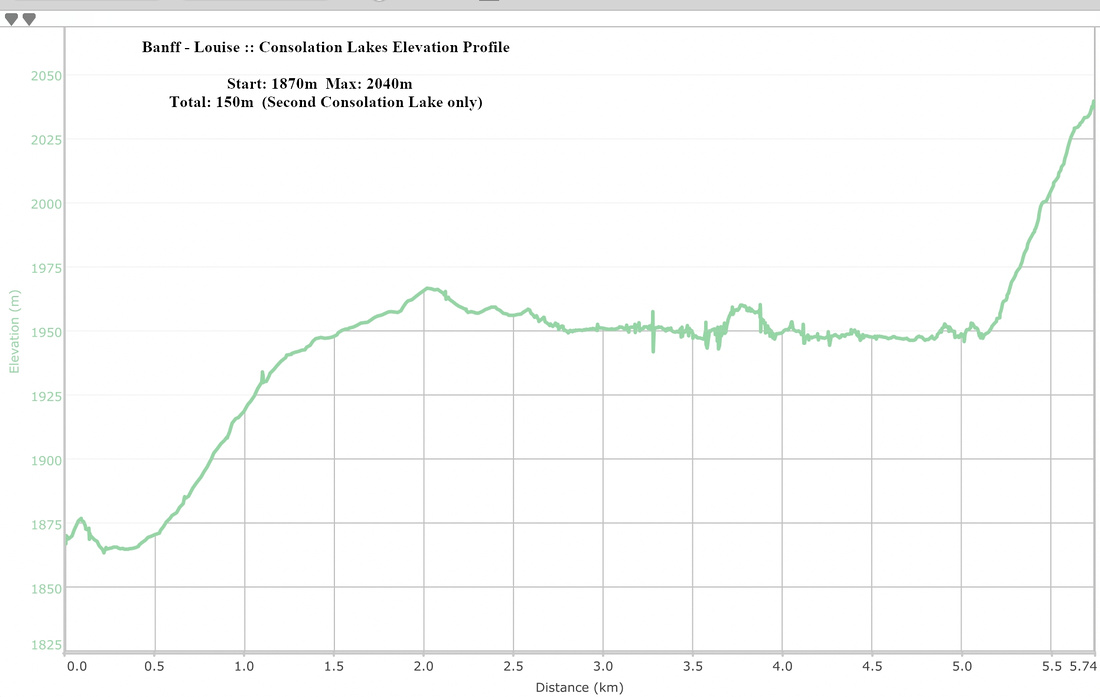 Consolation Lakes Elevation Profile