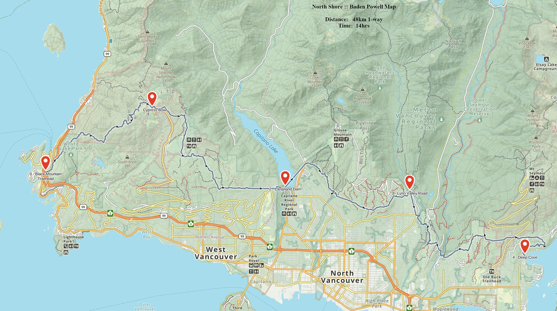
Google Map |
BC Coast :: North Shore :: Baden Powell |
GPS Track |
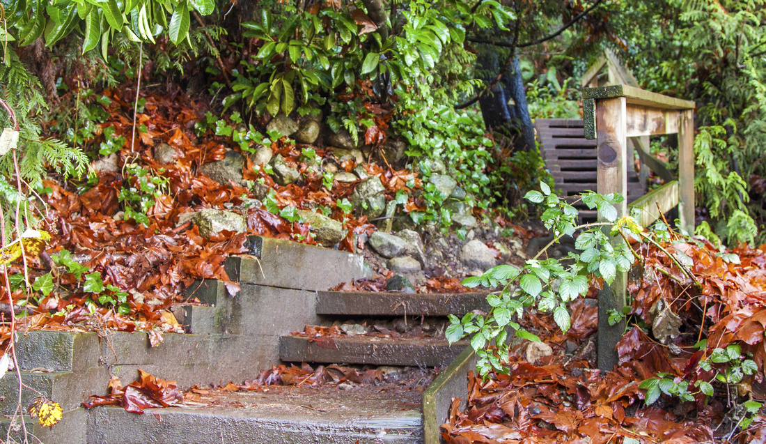 
Baden Powell East Trailhead in Deep Cove |
|||
|
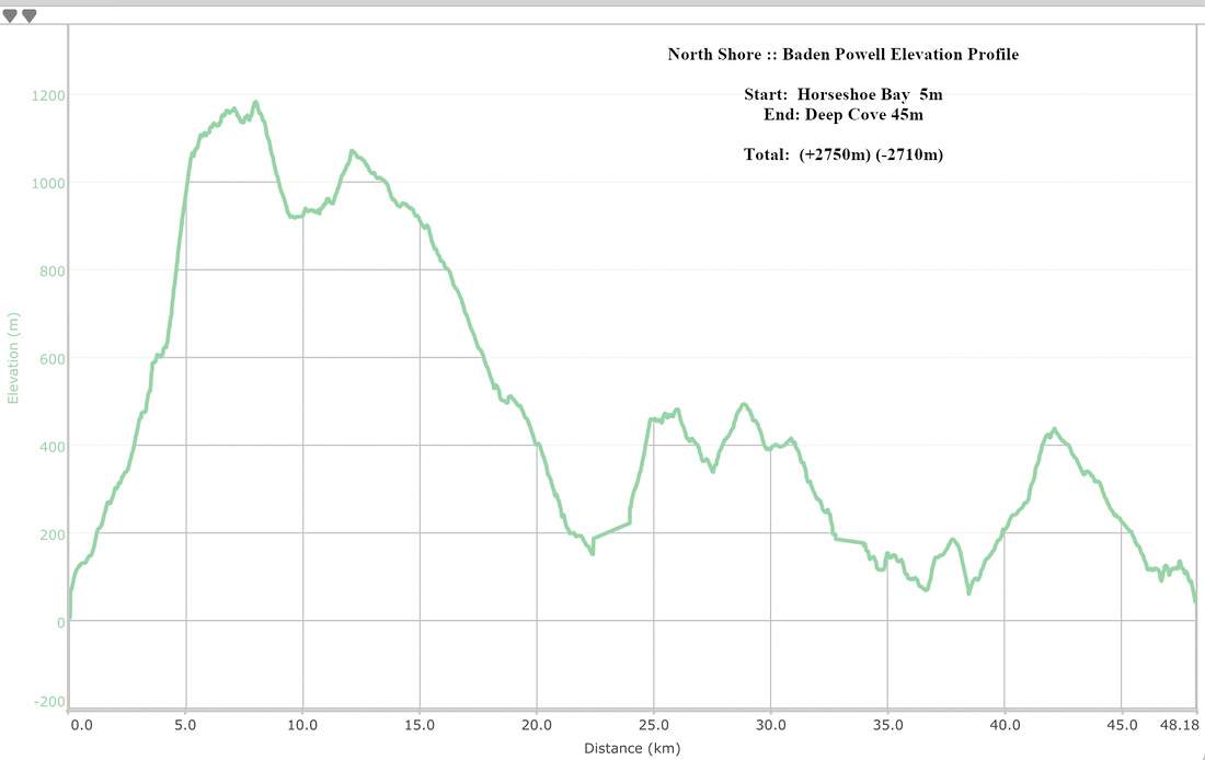
Baden Powell is one of best known trails both in Canada and globally. Built in 1971 to mark British Columbia Centennial it travels for some 48 km slopes of North Shore Mountains between Indian Arm and Howe Sound. East end is at Deep Cove under Mt. Seymour, while west terminus is at Black Mountain trailhead just above Horseshoe Bay. Much of the trail is below treeline, but besides spectacular old-growth rainforest there are many open viewpoints, including Eagle Bluffs -- hands down one of most awe-inspiring vistas I've ever seen. Trail itself is a hodge-podge with many ups and downs, bringing cumulative elevation gain (and loss) to above 2700m. Combined with distance and some rough parts, it makes an unlikely candidate for day-hike -- although it is sometimes done as part of "Iron Man" challenges and charity awareness events. At several low points trail travels briefly through residential areas which make usual start/end points for shorter day trips. Logical partitions in west-east direction are:
|
| Horseshoe Bay to Cypress Bowl | GPS Track | ||
|
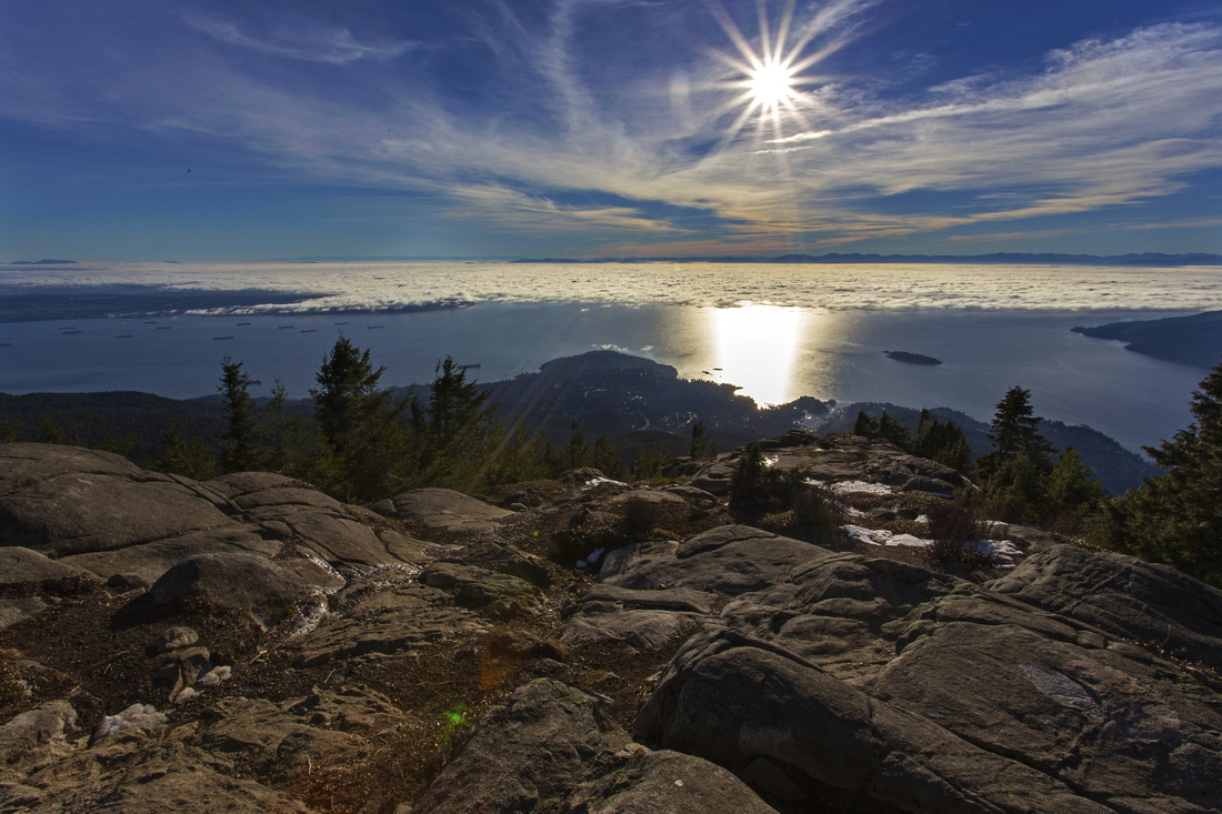
This section is arguably the most scenic of the 4. It is also the most demanding as it reaches the highest elevation on entire trail and has several steep and rough parts. Eagle Bluffs are the major attraction and frequently hiked from Cypress Bowl as half-day return trip. On this stretch you also have the only summit on entire Baden Powell -- Black Mountain. Snowshoes will be required in winter for Cypress Bowl part, while all other sections of BP are snow free throughout the year.
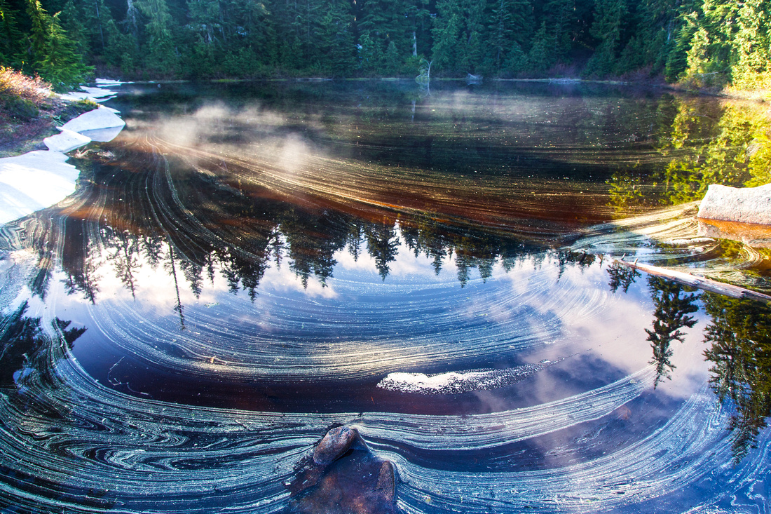
Start from Black Mountain trailhead above Horseshoe Bay. Driving west on Trans-Canada take exit 2 (not 3 which will take you to Ferry Terminal!), go around the traffic circle then watch for parking lot shortly after on the right side. There is room for 10-12 cars and surprisingly room can be found most of the time. Trail heads steeply up, crosses under the highway, then continues on the other side up the old logging road. Whyte Lake junction is about 30 minutes from the trailhead. Another hour of steady but moderate hiking brings you to end of logging road and start of real trail. It heads steeply up, crosses Nelson creek then climbs to large boulder field. This is the most challenging part of entire BP trail. When snow covered or wet it can be very tricky, specially on descent. Carefully climb up the boulders, then towards the top angle right in order to pick up the trail again. Several rough parts ensue and you have to use your hands to pull yourself up several short bluffs. Eventually forest starts thinning and you climb to Eagle Bluffs for well deserved break! Past the bluffs trail dips into old growth forest and heads north towards Black Mountain. Several tarns can be found and are fantastically photogenic in right conditions. BP does not connect with the summit directly so you have a choice of going over the peak at signed junction or following the BP in its entirety on the east side. Both routes join again near Cabin Lake (very beautiful and well-known swim hole in late summer). Final descent to Cypress Bowl is steep and often icy in spring.
Return options:
|
|||
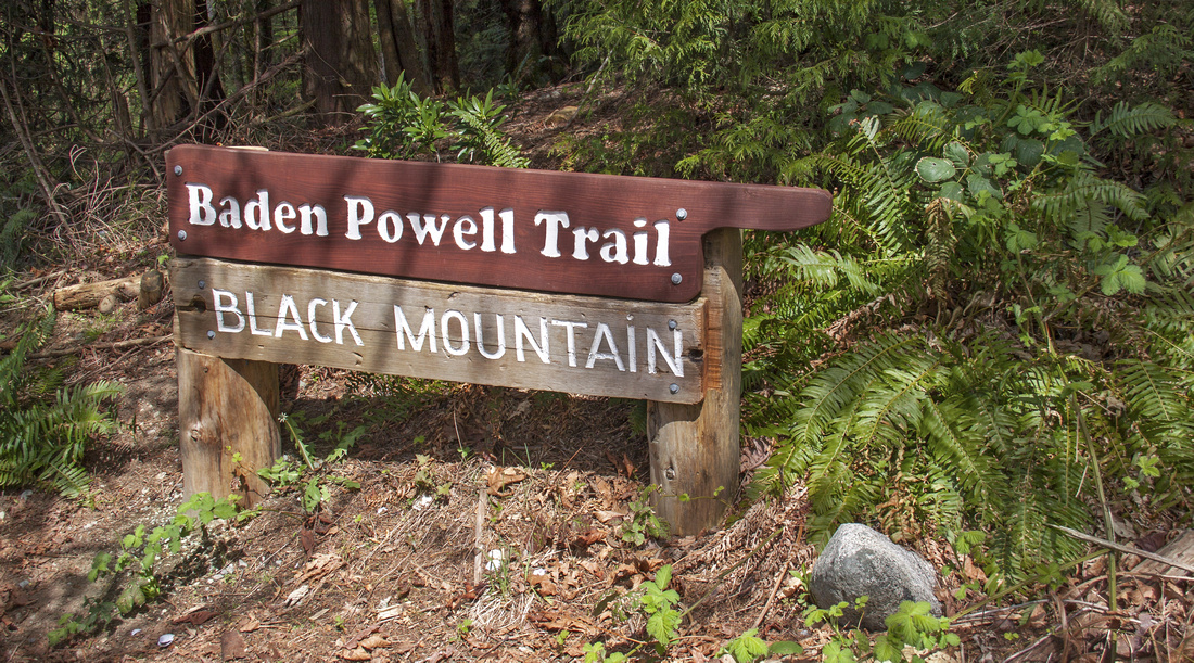 Black Mountain Trailhead and West Terminus of Baden Powell
 |
|||
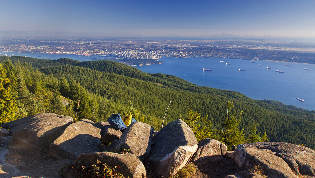 Burrard Strait and metro Vancouver from Eagle Bluffs
 |
|||
|
|
|||
 Black Mountain semi-forested summit above Cypress Bowl
 |
Abstract
| Overall Difficulty | D4/5 | Steep sections with several short bluffs in upper part. Tricky boulder field, specially when wet. | |||
| Snow Factor | S3 | Due to elevation upper part will be snowy in winter. Boulder field / exit to Eagle bluffs might prove challenging. Possibility of deep snow requiring snowshoes in Black Mountain area / descent to Cypress Bowl | |||
| Scenery | Spectacular views of Howe Sound, Burrard Strait and metro-Van from Eagle bluffs - one of best in lower Mainland! Pretty tarns and semi-open forest around Black Mountain. Good views of Howe Sound Crest and Mt. Strachan on descent to Cypress Bowl. | ||||
| Trail/Marking | Very Good | Generally well defined with BP signposts. Trail temporarily fades away in the boulder field and care is required to pick it up. | |||
| Suggested Time | 5-6 hrs | One-way from Horseshoe Bay to Cypress Bowl. If you don't have arranged transportation waiting at Cypress, add several hours for return back to Black Mountain trailhead (see options in main text) | |||
| Elevation | Start: 5m End: ~920m Total: (+1265m) (-350m) | Distance: 10 km | |||
| Gear | Day hikers or full boots. Gaiters suggested. Hiking poles very helpful for steep parts. Icers and or snowshoes in winter conditions | ||||
| Water | Seasonal streams can be found below boulder field and at Black Mountain plateau, but dry in between. Carry 1.5 - 2L | ||||
| Dog Friendly | Yes | Keep dog under control in Cypress Bowl as it is generally very busy area | |||
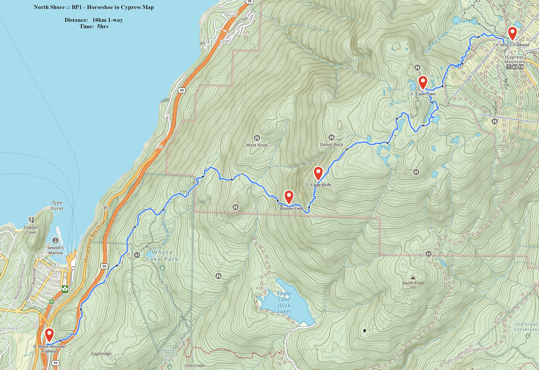 BP1 - Horseshoe to Cypress GAIA Map
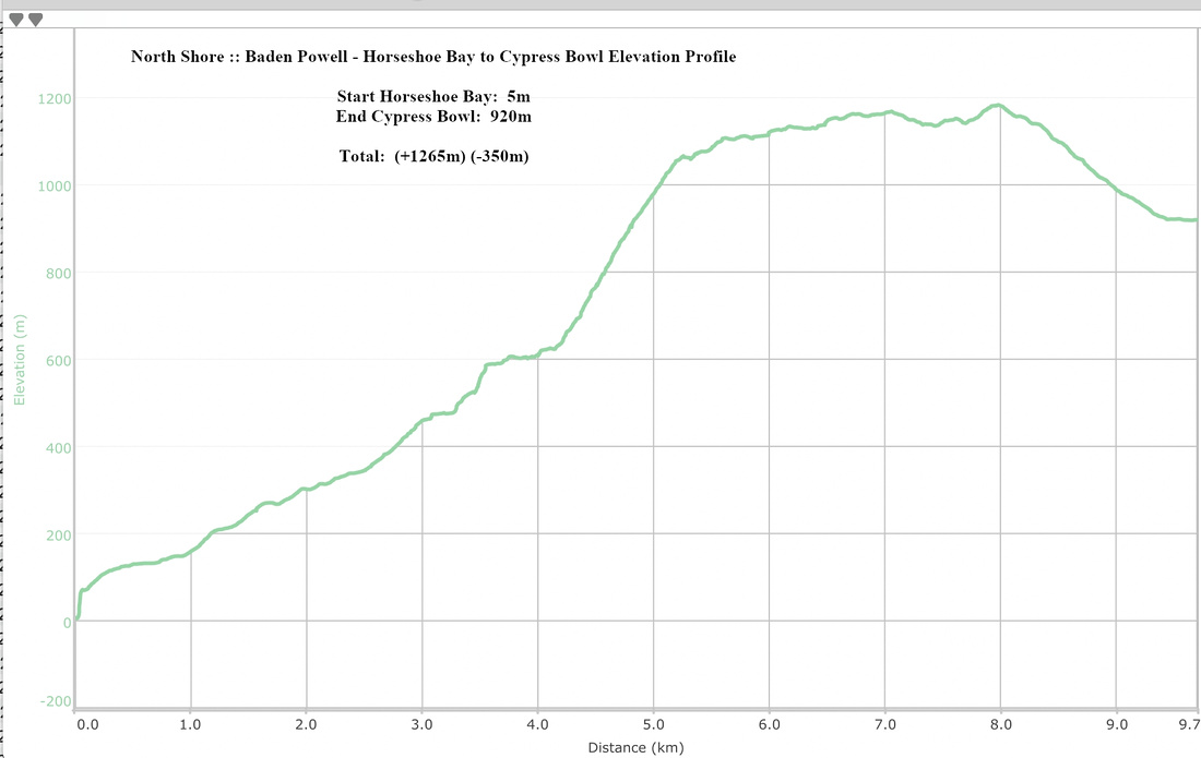 Baden Powell Horseshoe Bay to Cypress Bowl Elevation Profile
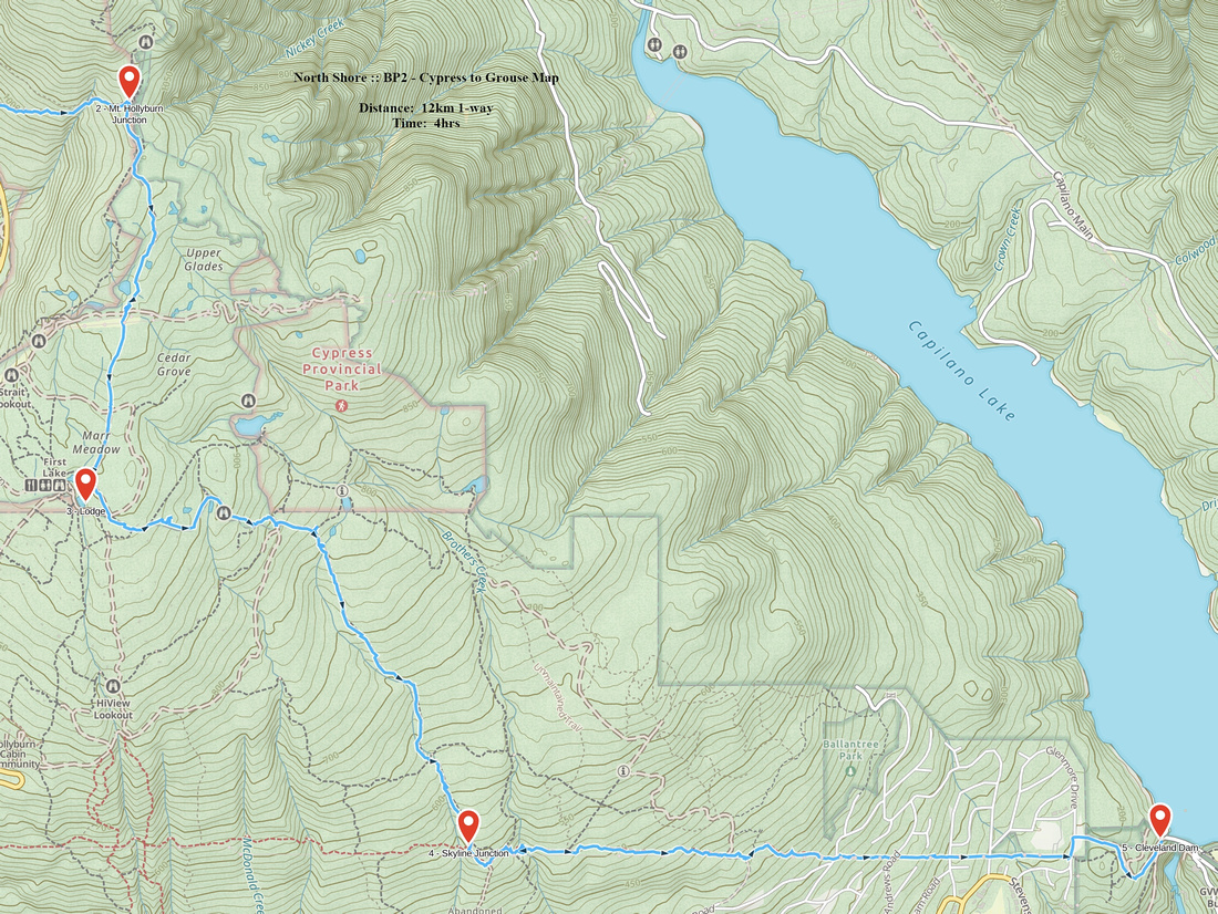
| Cypress Bowl to Grouse Mountain | GPS Track | ||
|
Note: Some will probably hike this section in opposite direction from the way it is presented here, but some might also descend as continuation of part 1. Thus we preserve original W -> E direction.
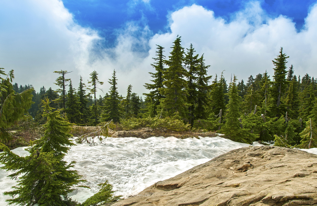
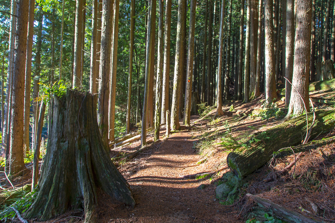
Although not as scenic as part 1, there are some fine viewpoints in part 2 as well -- including open views on south slopes of Hollyburn mountain, impressive old growth on descent down Brothers Creek (including pretty little waterfall -- see gallery photo), several typical North Shore tarns and finally postcard view of Capilano lake at the end. There are many possibilities for exploration along the maze of trails in Brothers Creek vicinity as well. Technically trail is nowhere as demanding as part 1 - it is all simple trail hiking.
Tiny bit of confusion waits at the start as it is not obvious where BP starts/continues in Cypress Bowl. From parking at end of the road head up east at right side of Strachan ski run. About 5-10 minutes in watch for familiar BP sign and trail that heads into the forest. Trail traverses west slopes of Hollyburn mountain; there are some rough stretches here and couple of creek crossings. About 30-40 minutes from parking you intersect Mt. Hollyburn trail; turn right (going left will bring you to Hollyburn summit in about 30 minutes, so if you have plenty of time it is good extension!). BP shares next section with Mt. Hollyburn summer trail, marked with orange squares. Do not follow all the way to parking lot; instead just before Hollyburn lodge go left down the powerline past couple of pretty nice tarns towards ski shelter. There are some nice open views of Grouse mountain to the east here. Several side trails come in here, but BP is always the widest and marked with familiar BP signs. There are also some interesting cabins here; one is named "Doghouse"! Trail now crosses boggy section on planks, goes past Blue Gentian lake junction and starts descent down Brothers creek. Stay straight on BP past Crossover trail junction and descend to junction with TCT (Trans-Canada Trail); turn left. Final stretch is shared with TCT and descends gradually in east direction. Many side trails (Lawson Heritage, Incline Railway, etc) come and go, but TCT/BP are always marked. Past Brothers Creek canyon (great photo-op) trail emerges to British Properties. Descend stairs to Millstream road and follow through residential for 20 minutes or so to Capilano lake and parking lot. Note: Next section (Grouse to Lynn) continues 2km up the road.
Return options:
|
|||
 One of many tarns on south slopes of Hollyburn mountain
 |
|||
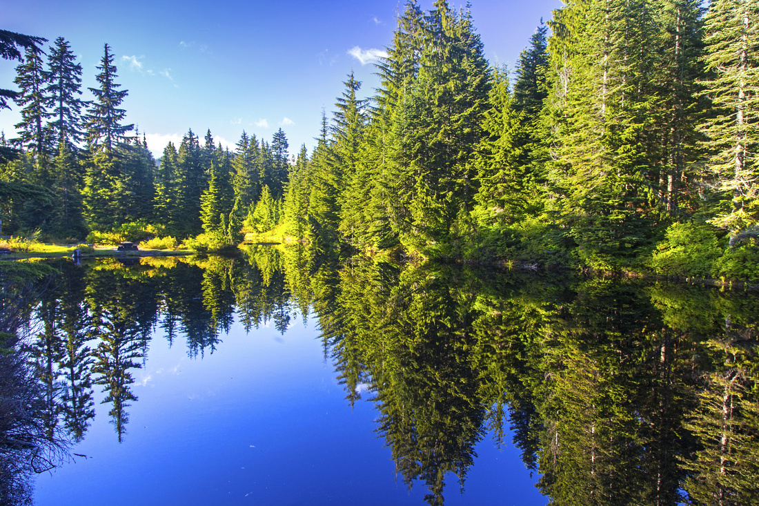 Picture perfect lake near Hollyburn Lodge
 |
|||
|
|
|||
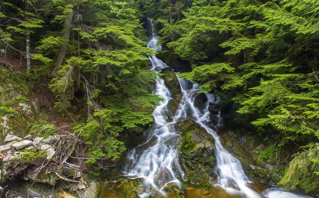 Typical North Shore Waterfall on Brothers Creek
 |
Abstract
| Overall Difficulty | D3/4 | Tricky, but bridged crossing of Brothers Creek near British Properties. Steep sections on slopes of Mt. Hollyburn. | |||
| Snow Factor | S3 | Due to higher elevation around Cypress Bowl, upper parts will be snowy and require snowshoes in winter conditions | |||
| Scenery | Capilano lake with views of Grouse Mountain and the Lions. Spectacular gorge and waterfall of Brothers Creek. Old growth forest. Open slopes of Mt. Hollyburn. | ||||
| Trail/Marking | Very Good | Trail well defined with standard BP signposts throughout. Section near Capilano Lake travels through residential area in British Properties | |||
| Suggested Time | 3-4 hrs | One way descent from Cypress Bowl to Capilano Lake. Add 1 hour if ascending | |||
| Elevation | Start: 970m Max: ~1070m Total: 1010m (descent), 240m (ascent) | Distance: 12.5 km | |||
| Gear | Full hiking boots preferable to day-hikers. Poles are helpful. Lower parts might be icy Jan - Mar, and upper require snowshoes. | ||||
| Water | Brothers Creek and several drainages draining on Mt. Hollyburn slopes. Carry 1 - 1.5 L | ||||
| Dog Friendly | Yes | Keep dog on leash while traveling through residential area and near Cypress Bowl | |||
 BP2 - Cypress to Grouse GAIA Map
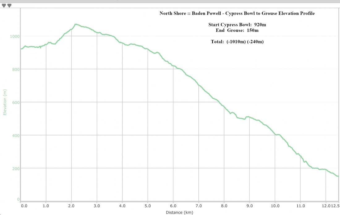 Baden Powell Cypress Bowl to Grouse Mountain Elevation Profile
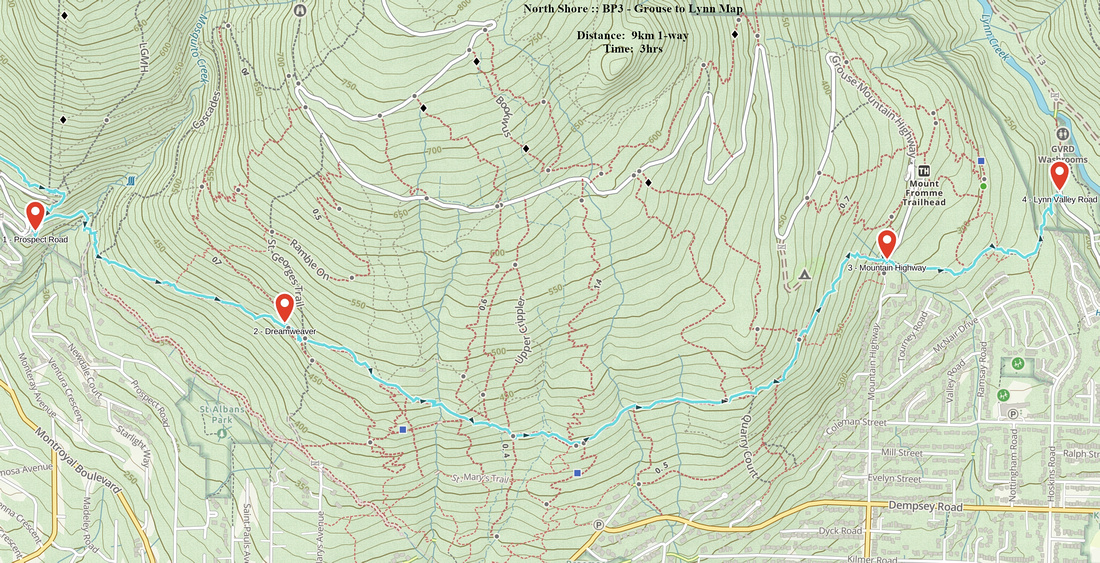
| Grouse Mountain to Lynn Valley | GPS Track | ||
|
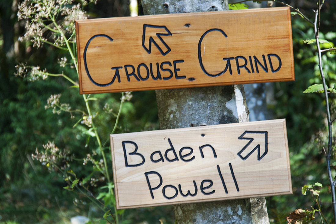
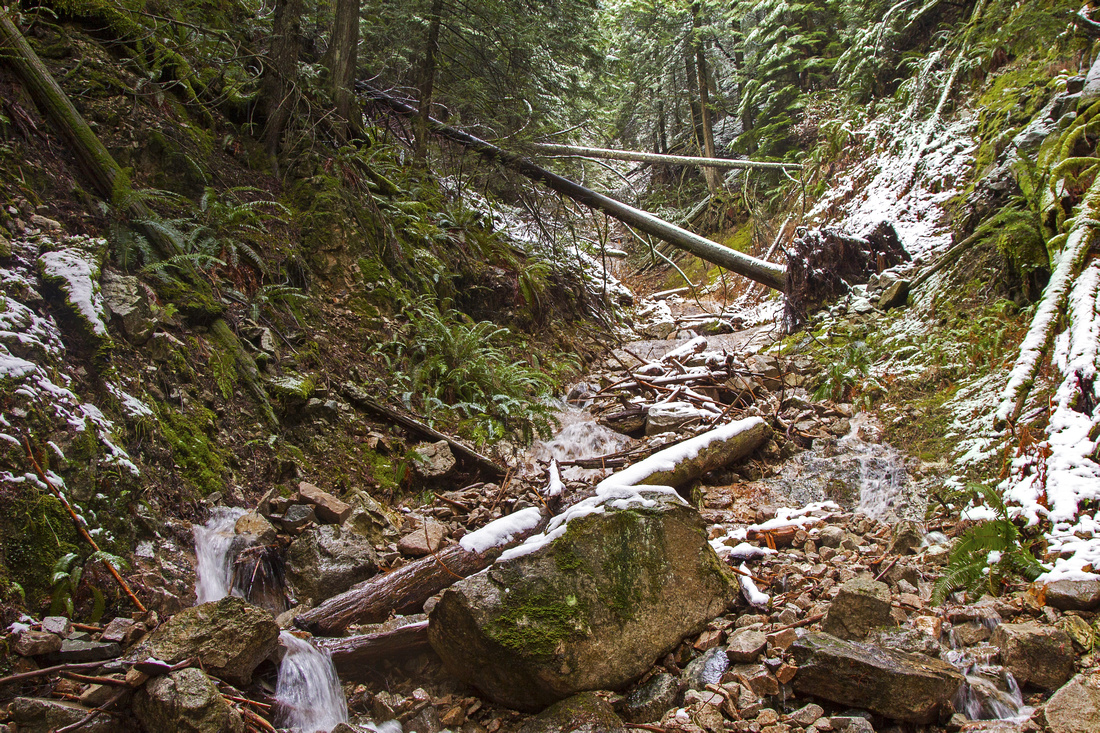
This is the shortest and least scenic section. BP stays low on south slopes of Grouse and Fromme mountains; most of the time is spent under tree cover. There are still couple of nice openings with views of metro-Van and Burrard strait as well as stretches of old growth forest. In second part BP traverses "Bike Grind" -- maze of mountain biking trails, well known across Canada (and beyond!). Section ends at Lynn valley road, about 1km from the gate where part 4 to Deep Cove resumes.
Park at top of Grouse Mountain road. Several parking lots fill fast and are also not free; an option is to leave the car lower down in residential area, then walk up to Skyride. Note that approximate distance from Capilano lake parking where part 2 finished is about 2km. Alternatively you can take public transport as Grouse Mountain is well served by Translink. Trailhead is shared with infamous "Grouse Grind" and is usually closed during winter months. If so, walk east on upper parking lot and simply head up into the forest at far end -- good bypass trail has developed and intersects GG/BP shortly; turn right. Soon the junction comes; GG goes left and uphill, while BP continues straight. Following section is fairly rough as you gain elevation and must traverse gullies draining lower Grouse mountain. Past junction with Larsen trail BP levels off, then starts gradual descent towards Mosquito creek. This is also Mt. Fromme trailhead at top of Prospect road. Cross Mosquito creek on good bridge then continue past water tank on BP. "Bike grind" comes in and there are too many junctions to describe; also be on alert for mountain bikers as they tend to come quite fast. Final bit descends across Mountain Highway and ends at Lynn Valley road.
Return options:
|
|||
 Baden Powell continues 2km north from Capilano Lake
 |
|||
 Trailhead at Grouse Skyride is shared with Grouse Grind
 |
|||
|
|
|||
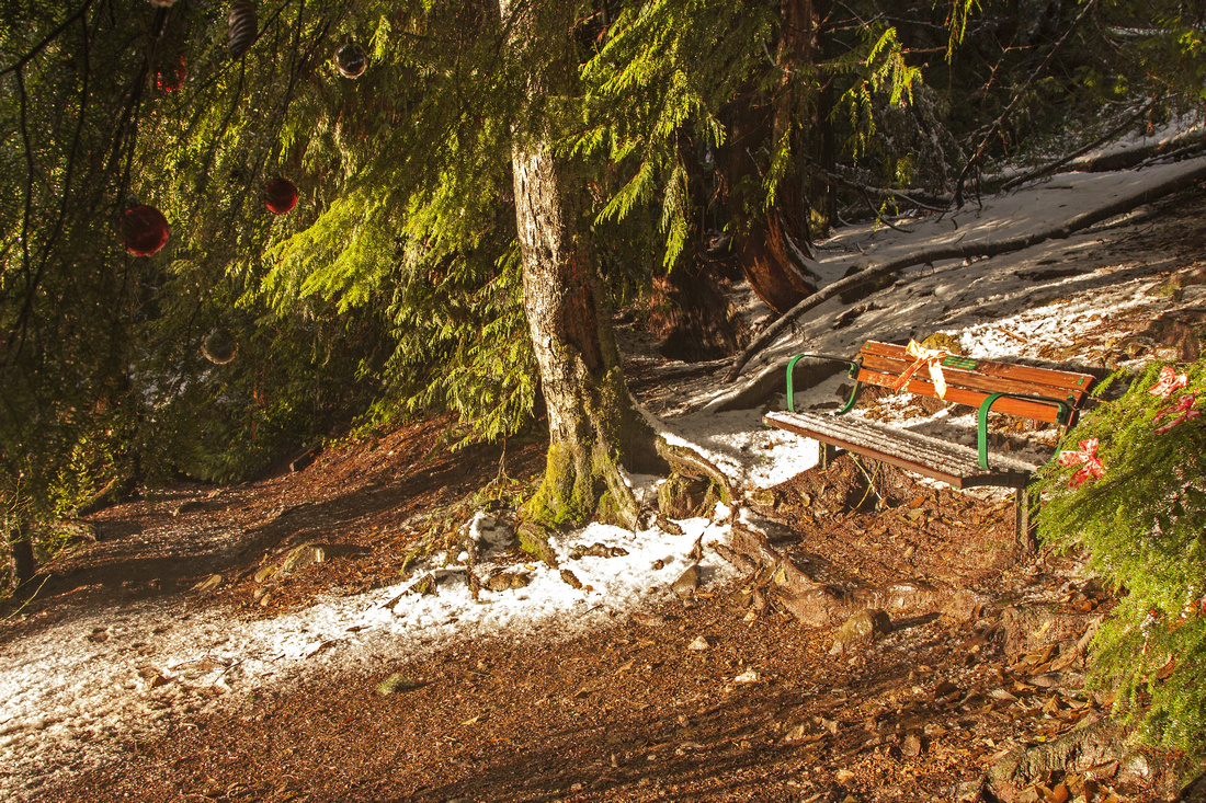 Sunlit bench on descent to Lynn Valley
 |
Abstract
| Overall Difficulty | D2/3 | Steep and rough sections below Grouse Mountain. Possible wet and boggy sections descending to Lynn Valley | |||
| Snow Factor | S2 | Entire section is generally below snowline year round. Possible icy sections Jan - March | |||
| Scenery | Some open views towards metro-Van. Sections of old growth | ||||
| Trail/Marking | Very Good | Trail well defined with standard BP signposts throughout. Some caution required to stay on trail in maze of biking trails below Fromme mountain | |||
| Suggested Time | 3-4 hrs | One way Grouse to Lynn. Multiply by 2 if walking back the same way | |||
| Elevation | Start: 250m Max: 500m Total: 470m (ascent), 530m (descent) | Distance: 9 km | |||
| Gear | Day hikers are sufficient. | ||||
| Water | Seasonal streams coming down Grouse and Fromme. Carry no more than 1L | ||||
| Dog Friendly | Yes | Keep dog on leash/under control specially around biking trails below Fromme mountain | |||
 BP3 - Grouse to Lynn GAIA Map
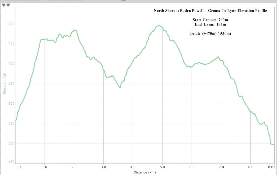 Baden Powell Grouse Mountain to Lynn Valley Elevation Profile
| Lynn Valley to Deep Cove | GPS Track | ||
|
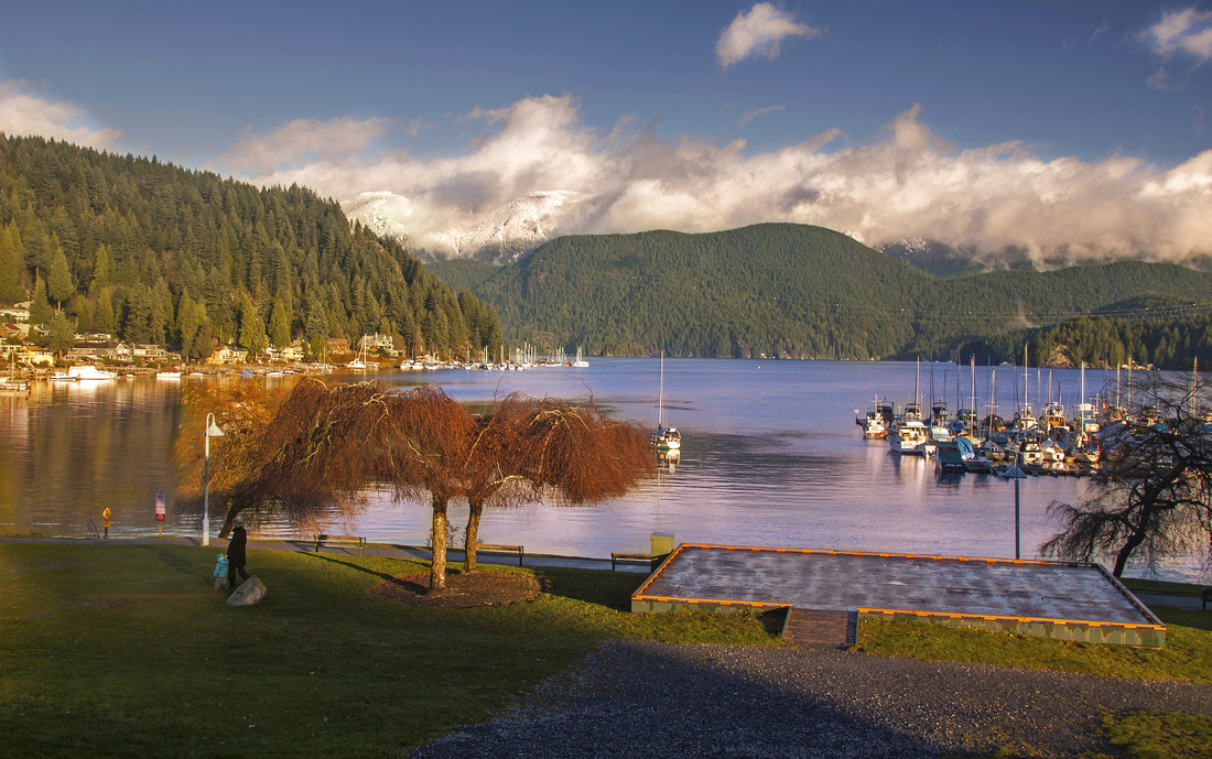
Like its west counterpart, east part of Baden Powell is also very scenic and travels through some interesting area. Although not as high as Cypress Bowl it does rise to mid-Seymour slopes so some snow is possible in winter months. Both ends can be very busy, but in the middle you can usually get some solitude and enjoy travel through typical old-growth forest. Major attractions are Lynn River suspension bridge and Deep Cove lookout (Indian Arm viewpoint). Trip ends in picturesque Deep Cove that has several nice bakeries for post-hike refreshments!
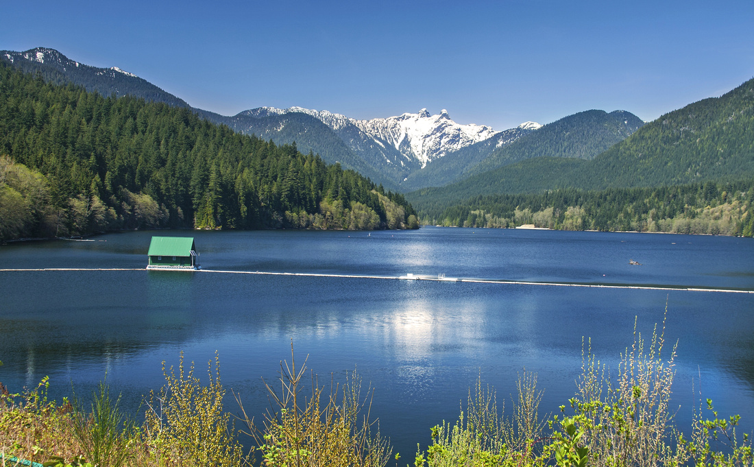
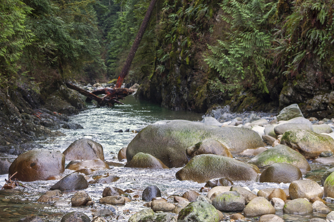
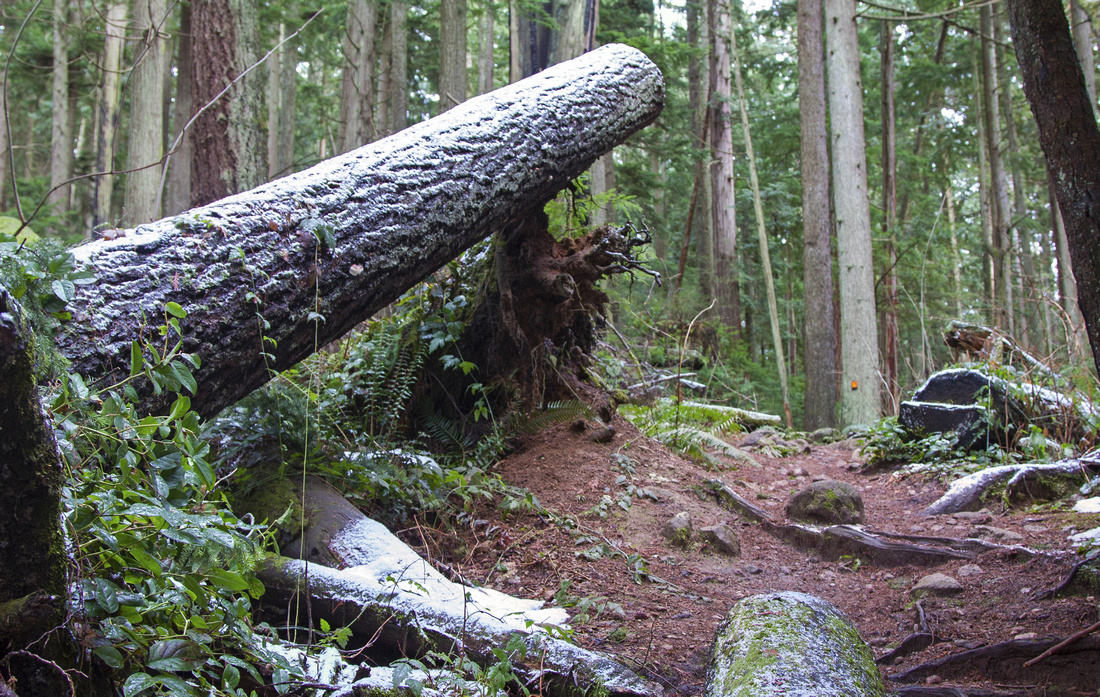
Park at one of side streets in front of Lynn Gate on top of Lynn Valley Road. There is small parking just in front of the gate, but often full. Baden Powell resumes on the right (east) side near the gate and descends to Lynn Canyon. This part is very attractive - Twin Falls, Lynn Suspension bridge and Ecology center are some of reasons why in summer you might have to fight for elbow space on the trail. All the tourist congestion behind, BP climbs out of Lynn Canyon and crosses over to LSCR (Lower Seymour Conservation Reserve). Cross the access road and follow markers down to bridge over Seymour River - be careful as this part is often very slippery! At far side of Seymour bridge turn left and follow Fisherman Trail for few minutes, then head right on signed junction. BP now rises through stretches of forest alternating with residential areas, to finally start climb to mid-Seymour past Hyannis drive. Sign informs you that Deep Cove is 8.3km away. Most of elevation gain on this part happens here, but it is over within 45 minutes or so and you enjoy nice walk through old growth forest before starting gradual descent towards Deep Cove. Like part 3, several bike trails intersect BP here so be on alert for fast riders coming down! Past Old Buck junction you cross Seymour road and reach Deep Cove lookout -- couple of open bluffs with great view across Indian Arm. On the other side is Eagle Ridge / Buntzen Lake area, accessed via Port Moody, and offers some very nice hiking opportunities as well. Last bit is actually quite rooty and rough - just to remind you this is North Shore after all. Finally you reach east terminus at base of wooden stairs -- see leading photo on this page. Congratulations - you have just hiked Baden Powell, one of premier trails on the Coast and Canada!
For return best option is to take public transport back to Lynn Gate: 212 to Phibbs Exchange, then 210 to Lynn Gate. For more details see Translink Website |
|||
 Descending the canyon near Lynn River suspension bridge
 |
|||
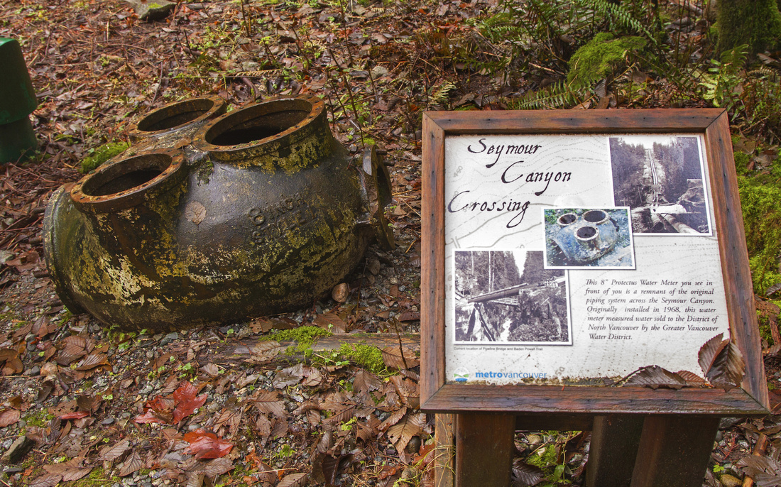 Interesting artifacts near crossing of Seymour River
 |
|||
|
|
|||
 Views across Indian Arm from trail end in Deep Cove
 |
Abstract
| Overall Difficulty | D3 | Some steep and rough sections. Trail is very rooty on descent from Deep Cove lookout | |||
| Snow Factor | S2 | Generally snow free year-round, except for brief section in mid-Seymour. Possibility of icy sections Jan - Mar | |||
| Scenery | Lynn Canyon and suspension bridge. Old growth on slopes of Mt. Seymour. Deep Cove lookout with views of Indian Arm | ||||
| Trail/Marking | Very Good | Trail well defined with standard BP markers throughout. Caution required to stay on trail around LSCR / crossing of Seymour river | |||
| Suggested Time | 5-6 hrs | One way Lynn to Deep Cove. Multiply by 2 if walking back the same way | |||
| Elevation | Start: 170m Max: 440m Total: 470m (ascent), 530m (descent) | Distance: 14 km | |||
| Gear | Day hikers are sufficient. | ||||
| Water | Seymour portion past LSCR will be dry. Carry 1 - 1.5L | ||||
| Dog Friendly | Yes | Please keep dogs on leash / under control around Lynn Canyon and past Deep Cove lookout as those are busiest areas | |||
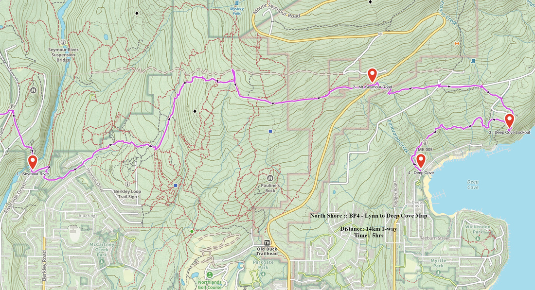 BP4 - Lynn to Deep Cove GAIA Map
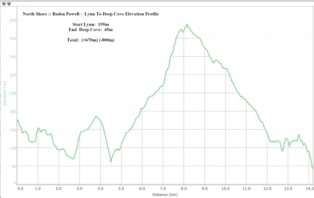 Baden Powell Lynn Valley to Deep Cove Elevation Profile